


Get to know Pingtang County
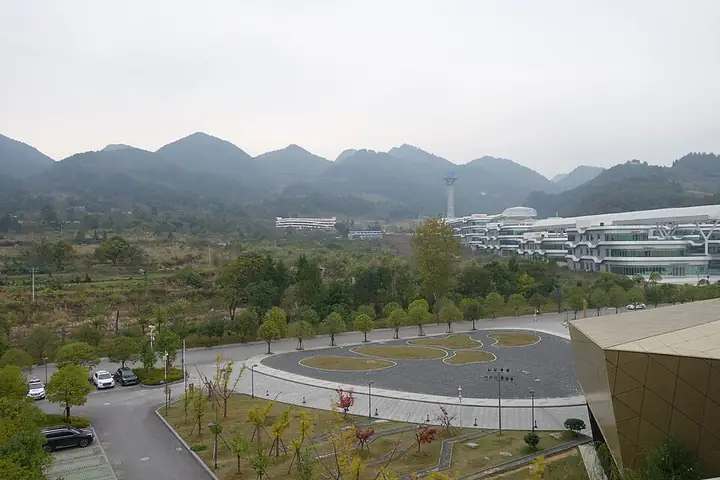
Photo adjustments
Full-frame source proportionally resized and converted to WebP for display. No subject alteration. Source-supplied marks and edits remain; cards may crop the view.
- Administrative area
- County · 县
- Part of
- Qiannan Buyei and Miao Autonomous Prefecture
- Chinese name
- 平塘县
- Local areas
- County guide
Area & population
- Area in the source
- 2,799.08 km²
- Population · 2010
- 228,377
- Administrative seat
- Jinpen
Source: cited geographic source, as of the dates shown.
What to see
FAST came into use on 25 September 2016; the county presents it as the world's largest single-dish radio telescope. The "China Sky Eye" scenic area around it (中国天眼景区) covers 3.47 square kilometres in two parts, the Pingtang Astronomy Town (平塘天文小镇) and the viewing zone. It includes a Sky Eye viewing deck, an astronomy experience hall and a memorial hall to Nan Rendong (南仁东).
The Zhangbu scenic area (掌布景区), 65 kilometres from the county town, was the first national 4A scenic area in Qiannan. It follows a six-kilometre karst gorge on the Langma stretch of the upper Caodu River (槽渡河), with cliffs and many karst caves. Zhangbu is famous for the "character stone" (藏字石), a boulder of about a hundred tonnes that split in two when it fell; the split face shows five raised characters reading "Communist Party of China". In December 2003 an expert panel invited by the county explained the shapes as fossils and bioclastic debris in Middle Permian Qixia Formation rock, brought out by dissolution and uneven weathering. About 3 kilometres into the gorge, more than 300 stone "eggs" 30 to 40 centimetres across are set into a riverside rock wall.
The Jiacha waterfall (甲茶瀑布) at Jiacha village is 40 metres wide and 37 metres high.
Setting and landscape
The county town lies in the east of the county on the Pingzhou River (平舟河), which wraps around it on the south, west and north, while Longnao Hill (龙脑坡), 789 metres high, rises to the east. The town has long been called "jade water, golden basin" (玉水金盆). Yanghe Mountain (养鹤山), 1,063 metres high and 8 kilometres west of the town, is a spot for watching the sunrise. The climate is humid mid-subtropical monsoon.
History
Under the Tang the area first had two jimi prefectures, loosely governed frontier units named Nanping (南平州) and Dong (动州). Pingtang County dates from 1 July 1941, when the Republican government merged Pingzhou (平舟) and Datang (大塘) counties; the seat moved to the old Pingzhou county town that August. The county was abolished in 1958, split along the Caodu River between Luodian (罗甸) and Dushan (独山), and restored in 1961.
Two traditions from the county are on the national intangible heritage list: the firing of Yazhou pottery (牙舟陶), a craft with more than 600 years of history, and the monkey-drum dance (打猴鼓舞) of the Maonan people (毛南族). The county's Kapu (卡蒲) is a Maonan ethnic township.
Highlights
- China Sky Eye scenic area 中国天眼景区: 3.47 sq km area at Kedu around the FAST radio telescope, with a viewing deck and a Nan Rendong memorial hall.
- Zhangbu scenic area 掌布景区: Qiannan's first national 4A scenic area, a six-kilometre karst gorge on the upper Caodu River.
- Character stone 藏字石: Split boulder in the Zhangbu gorge whose face shows five raised characters, explained by a 2003 expert panel as weathered fossil debris.
- Jiacha waterfall 甲茶瀑布: 40 metres wide and 37 metres high.
- Yazhou pottery 牙舟陶: Pottery tradition of more than 600 years, on the national intangible heritage list.
Sources for this guide
平塘县人民政府-平塘简介 · Pingtang County People's Government
平塘县人民政府-历史沿革 · Pingtang County People's Government
“中国天眼”景区简介 · Pingtang County People's Government (Guizhou Pingtang Wentian Tourism Development Co.)
掌布“藏字石”景区 · Pingtang County Bureau of Culture, Radio, Television and Tourism
平塘自然景观景点 · Pingtang County Bureau of Culture, Radio, Television and Tourism
Original English written from the listed sources and checked sentence by sentence against quoted extracts by a separate reviewer. Updated 2026-09-24.
Explore Pingtang County
Core places to explore, with English and Chinese names.
Places to explore around Pingtang County
 China Sky Eye Science Centre · 中国天眼科普基地
China Sky Eye Science Centre中国天眼科普基地
The China Sky Eye science-popularisation complex (中国天眼科普基地) is the public side of the scenic area at Kedu town in Pingtang County, southern Guizhou, built around the Five-hundred-metre Aperture Spherical radio Telescope known as FAST. The scenic area covers 3.47 square kilometres and falls into two zones, the Pingtang astronomy town and the Sky Eye sightseeing area.
Read the place guide → AI illustration · AI 示意图(仅供参考,非该地点实拍)
Zhangbu Scenic Area掌布
Zhangbu (掌布) is a karst gorge scenic area in Zhangbu town, Pingtang County, in the Qiannan prefecture of southern Guizhou, about 65 kilometres from the county seat. It covers some 10 square kilometres along the Langma river reach of the upper Caodu river and is rated a national AAAA scenic area.
Read the place guide →Plan your visit
Getting there
Pingtang County is about 50 km in a straight line from central Qiannan Buyei and Miao Autonomous Prefecture. Search for 平塘县 in a map app to find stations and your accommodation.
Where to stay →Build your route
China Sky Eye Science Centre and Zhangbu Scenic Area are both listed here. The linked place guides have entrance and visit details.
Continue with Qiannan Buyei and Miao Autonomous Prefecture →More in Qiannan Buyei and Miao Autonomous Prefecture
Sources & geographic information
Administrative names and parent areas: Official geographic directory · Reference date 2026-09-06.
Photo: China Sky Eye Science Centre · Source photographer · License not provided. EXIF orientation normalized; resized without changing aspect ratio; converted to WebP. No subject edits.
Map data © OpenStreetMap contributors. Pins mark approximate centres, not entrances or boundaries.