

Explore the region
Tap any red Chinese text to hear it in Mandarin.
Wuling Mountain is in Xinglong County, within Chengde, rather than in Chengde’s urban resort valley. The Ministry of Ecology and Environment records the reserve as established in 1983 to protect a relatively complete warm-temperate forest ecosystem. The highest peak is 2,118.6 metres, and the vegetation changes with elevation from pine and oak through broadleaf forest and higher conifers to subalpine meadow and scrub. That vertical sequence is the mountain’s clearest natural story.
The reserve is also a working conservation landscape, not simply a mountain-top lookout. A 2025 forestry report describes fire prevention, wildlife monitoring and carefully managed ecological tourism, while a recent English-language Xinhua report places visitors and autumn scenery in Wuling Mountain National Nature Reserve in Xinglong County. Keep to an approved visitor section and treat the forest, water and changing altitude as the subject of the visit.
What to look for
Start by noticing how the forest changes as the road or trail gains height. Lower woodland, denser broadleaf stands, conifers and the exposed upper landscape do not feel like one uniform forest; weather can also change quickly between the approach road and high viewpoints. The Ministry’s vegetation sequence is a useful field guide rather than a promise that every belt is open to visitors.
For a more enclosed walk, choose a currently open stream or waterfall section. The Beijing Miyun government’s description of the Longtan section names linked pools, cliffs and the 56-metre Longtan Waterfall, with smaller falls nearby. This is the Miyun-side visitor section, so do not assume that its route or entrance is interchangeable with the Hebei-side gate.
Older tourism material groups the visitor landscape into Xianren Tower, Wulongtou, Longtan and Qingliangjie sections. These names describe scenic sections within a protected mountain landscape, not four separate cities or proof that one ticket covers every road. The reserve boundary and a permitted visitor route are different things.
Gates and practical access
The Hebei approach
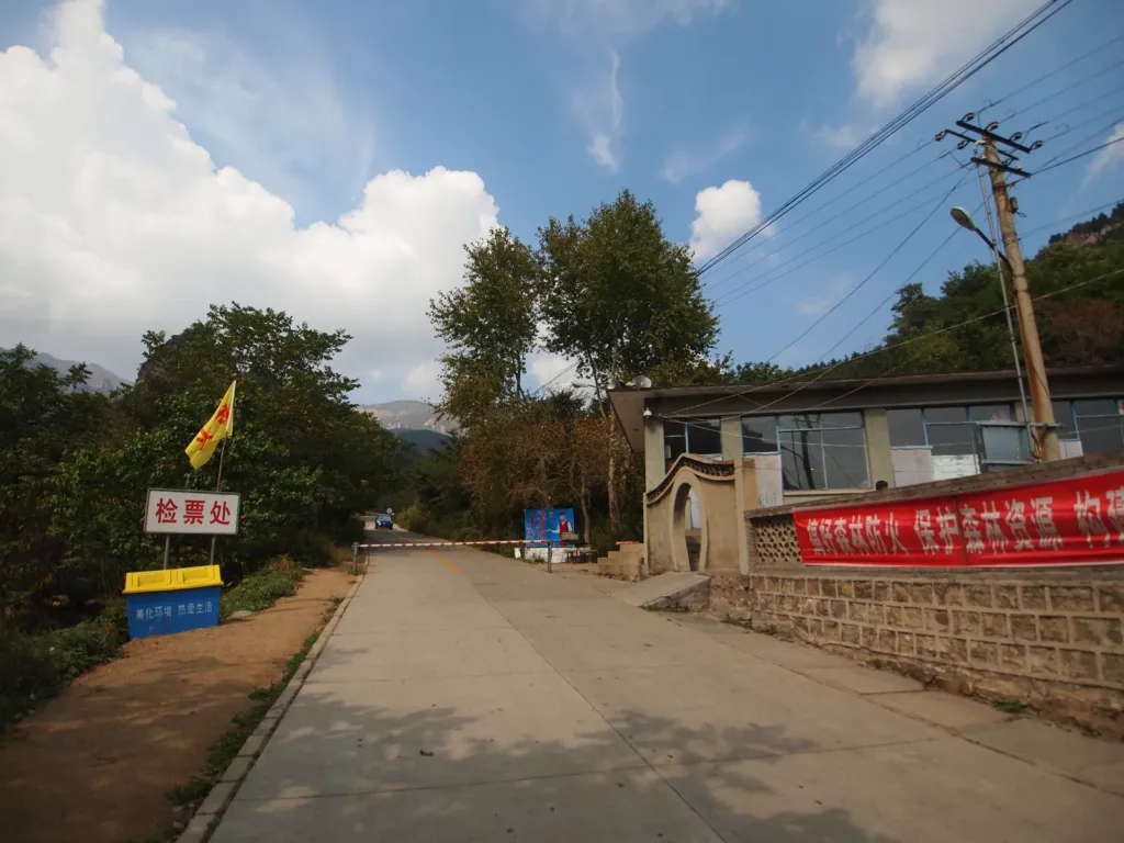
For the Chengde side, search the Chinese destination 雾灵山景区正门(南门) or 雾灵山风景区 Wùlíng Shān Fēngjǐngqū, rather than relying on the English name alone. A current Trip.com destination listing gives the main address as roughly one kilometre north of Yanshi Village in Wuling Mountain Township, Xinglong County: 承德市兴隆县雾灵山乡眼石村北约1公里,雾灵山景区正门(南门). Treat this as a destination label to confirm on the day, not as proof of current opening or ticket conditions.
The useful rail gateway is 兴隆县西站 (Xinglongxian West Railway Station) on the Beijing–Harbin high-speed railway’s Beijing–Shenyang section. The Chengde municipal government’s opening report lists Beijing Chaoyang, Miyun, Xinglong County West, Anjiang and Chengde South among the stations between Beijing and Chengde. From the station, I found no verified regular tourist bus or reserve-operated shuttle to the Hebei south gate. Arrange a licensed taxi or private transfer to the exact Chinese gate before travelling, and arrange the return to the station before entering the mountain.
承德南站 (Chengde South Railway Station) is another real station on the same high-speed corridor, but it is not the visitor entrance. A ticket to Chengde does not remove the separate road transfer to Xinglong County and the mountain gate. Check the named station on the ticket and keep the Chinese destination ready for the driver.
The Beijing-side approach
The north and west gates are a separate approach through 北京市密云区新城子镇曹家路村南 Běijīng Shì Mìyún Qū Xīnchéngzi Zhèn Cáojiālù Cūn Nán. The local government identifies 雾灵山风景区—龙潭景区 Wùlíng Shān Fēngjǐngqū — Lóngtán Jǐngqū as the destination and states that the west and north gates are there. Its public-transport description is 东直门 → 980快 → 密云西大桥 → 密38 → 曹家路村, followed by about 7 km on foot. This is useful evidence for the Miyun-side Longtan route, not a shortcut to the Hebei south gate.
If you use the Miyun route, confirm the last bus and your return connection before starting the walk; the local notice does not give a current timetable or a reserve shuttle. Do not plan to enter through one gate and leave through another unless the operator confirms that the relevant sections and transport are open that day.
Check before setting out
Public tourism listings are not consistent: one gives May–October as the best season, while another lists year-round visits and a 09:00–17:00 opening; both treat prices as reference information rather than a current operator notice. The forestry report also says that the key forest-fire-prevention period begins on 15 October. Confirm the exact gate, permitted section, current opening, ticketing, weather or fire restrictions and any internal vehicle arrangement with the reserve or scenic-area operator before travelling. I found no current official public notice explaining foreign-passport booking or check-in, so do not assume that a domestic online ticket procedure applies.
Find Wuling Mountain
雾灵山 · 兴隆县
The pin marks the area, not the entrance.
Sources & visit information
Sources checked on 25 October 2026. Hours, tickets, reservations and transport can change; confirm with the operator before you go.
Image credits & notes (1)
- South Entrance (南门) of Wuling Mountain on the Hebei/Xinglong side, photographed on 23 September 2012; the image documents the gate scene, not current operations. Photo: rheinsPhoto: CC BY 3.0