


Get to know Xinglong County
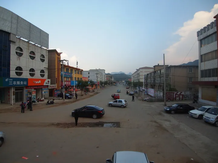
Photo adjustments
Full frame retained; proportionally resized and converted to WebP. No retouching or changes to the photographed subject. Card displays may crop the view.
- Administrative area
- County · 县
- Part of
- Chengde
- Chinese name
- 兴隆县
- Local areas
- County guide
Area & population
- Area in the source
- 3,116.00 km²
- Population · 2020 census
- 271,628
- Administrative seat
- Xinglong Town (兴隆镇)
Source: cited geographic source, as of the dates shown.
History
Neolithic finds at Dongmiaohe (洞庙河), Banbishan (半壁山) and other sites show early settlement, and in the Shang the area belonged to the state of Guzhu (孤竹). After the Qing began building imperial tombs at Malanyu (马兰峪) in Zunhua in 1661, most of Xinglong was sealed off as the "rear dragon" fengshui zone behind the Eastern Qing Tombs and placed under the Malan garrison. The ban lasted 254 years until the zone was opened in 1915, and Xinglong became a county in August 1930.
Setting and landscape
Wuling Mountain (雾灵山), in the north of the county, is the main peak of the Yanshan (燕山) range at 2,118 metres and forms the watershed between the Luan (滦河) and Hai (海河) river systems. It became a provincial nature reserve in 1982 and a national one in 1988. The county's profile describes a layered mountain climate, with peach trees in blossom below while snow falls on the heights. The Chengde government puts forest cover at 71.2 percent and the summer mean temperature at 21 °C.
What to see
The Wuling Mountain ecological tourism area reopened in 2024 after renovation. The Xinglong Observation Station of the National Astronomical Observatories, Chinese Academy of Sciences (国家天文台兴隆观测基地), stands at 960 metres on the southern slopes of the Yanshan main peak; its telescopes include a 2.16-metre telescope and the 4-metre LAMOST spectroscopic survey telescope, and the Chengde government calls it the largest optical astronomy base in Asia. Other scenic areas named in county and city profiles include Liuliping (六里坪) provincial forest park, the Jiulongtan (九龙潭) gorges, the Xinglong karst caves (兴隆溶洞), Tianzishan (天子山) and Qishigu (奇石谷, "strange-stone valley"); Xinglong Mountain (兴隆山) is used for hiking.
Food and local products
Chestnuts have been grown here since the Warring States period, and in 2001 the State Forestry Administration named Xinglong China's "home of chestnuts". Hawthorn cultivation goes back more than 400 years: in the Jiaqing reign (1796–1820) merchants carried hawthorns from around the fengshui zone to Shuntian, Baoding and other prefectures as food and medicine. Xinglong leads all Chinese counties in hawthorn area and output and holds the title "home of hawthorn".
Getting oriented
The county town is 165 km from Beijing, 170 km from Tianjin and 150 km from Tangshan. The Beijing–Chengde railway stops at Xinglong County station, and the high-speed line from Beijing stops at Xinglong County West; national highways 112 and 233 also cross the county.
Highlights
- Wuling Mountain 雾灵山: Main peak of the Yanshan range at 2,118 m; national nature reserve since 1988.
- Xinglong Observation Station 国家天文台兴隆观测基地: Observatory at 960 m with the 4-metre LAMOST telescope.
- Xinglong hawthorn 兴隆山楂: Grown for over 400 years; the county leads China in hawthorn area and output.
- Xinglong chestnuts 兴隆板栗: Grown since the Warring States; named China's home of chestnuts in 2001.
Sources for this guide
承德市人民政府 网上新闻发布厅 承德市政府新闻办承德“十四五”高质量发展承德答卷系列新闻发布会——“山水藏韵 文旅焕新”构建文旅产业发展新格局新闻发布会文字实录 · Chengde Municipal People's Government
【河北县情概览】承德市兴隆县 · The Paper (government channel, Hebei county profile series)
雾灵山 - 维基百科,自由的百科全书 · Wikipedia · CC BY-SA 4.0
国家天文台兴隆观测基地 - 维基百科,自由的百科全书 · Wikipedia · CC BY-SA 4.0
兴隆县 - 维基百科,自由的百科全书 · Wikipedia · CC BY-SA 4.0
Original English written from the listed sources and checked sentence by sentence against quoted extracts by a separate reviewer. Updated 2026-09-24.
Explore Xinglong County
Core places to explore, with English and Chinese names.
Places to explore around Xinglong County
 Rocky summit view from Wuling Mountain in Xinglong County, Hebei · 河北省兴隆县雾灵山山顶景色 Source-recorded photograph date: Taken on 19 October 2008.
Wuling Mountain雾灵山
Wuling Mountain is a forested Yanshan mountain landscape centred on Xinglong County near the Beijing boundary.
Read the place guide → AI illustration · AI 示意图(仅供参考,非该地点实拍)
Xinglong Mountain Scenic Area兴隆山
Xinglongshan (兴隆山) is a rugged Yanshan mountain scenic area near Mizidi Village in Xinglong County, forming one of the four scenic sections of Hebei Xinglong National Geopark.
Read the place guide →Plan your visit
Getting there
Xinglong County is about 70 km in a straight line from central Chengde. Search for 兴隆县 in a map app to find stations and your accommodation.
Where to stay →Build your route
Wuling Mountain and Xinglong Mountain Scenic Area are both listed here. The linked place guides have entrance and visit details.
Continue with Chengde →More in Chengde
Sources & geographic information
Administrative names and parent areas: Official geographic directory · Reference date 2026-09-06.
Some facts checked against 雾灵山 — Wikipedia contributors, CC BY-SA 4.0.
Some facts checked against 国家天文台兴隆观测基地 — Wikipedia contributors, CC BY-SA 4.0.
Some facts checked against 兴隆县 — Wikipedia contributors, CC BY-SA 4.0.
Photo: Wuling Mountain · Tiger@西北 · CC BY-SA 3.0. Full frame retained; proportionally resized and converted to WebP. No retouching or changes to the photographed subject. Card displays may crop the view.

Map data © OpenStreetMap contributors. Pins mark approximate centres, not entrances or boundaries.