


Get to know Wu'an
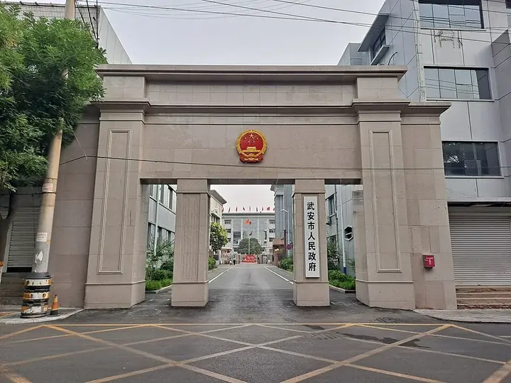
Photo adjustments
Full frame retained; resized proportionally to a maximum dimension of 960 pixels and converted to WebP quality 88. No crop, retouch, generated elements, or subject alteration. Final website rendition: full frame retained, proportionally resized to at most 720 pixels and converted to WebP. No additional retouching or subject alteration. Card displays may crop the view.
- Administrative area
- County-level city · 县级市
- Part of
- Handan
- Chinese name
- 武安市
- Local areas
- County-level city guide
Area & population
- Area in the source
- 1,806.00 km²
- Population · 2020
- 811,631
Source: cited geographic source, as of the dates shown.
History
In the Warring States period the place was Wu'an town (武安邑) of the state of Zhao (赵国), and a Wu'an County already existed under the Han dynasty. In the Republican period it belonged to Henan province; in 1949 it came under the Handan prefecture of Hebei, and the county became a city in 1988. The Cishan site (磁山遗址) is a major historical and cultural site protected at the national level.
The ground holds large reserves of iron, coal and limestone, and its iron ore is counted among China's four richest deposits. The Xinxing Ductile Iron Pipes company (新兴铸管), set up by the army's General Logistics Department, counts Wu'an among its production bases. People's Daily describes a shift from resource-based industry towards tourism since November 2016, when the city became a candidate national all-for-one tourism demonstration area.
What to see
Dongtaihang (东太行) takes its name from its position on the eastern flank of the Taihang range. People's Daily gives it a planned area of 26 square kilometres and a highest point of 1,428 metres, with cliff-face plank walkways built above 1,000 metres; the 129th Division was once stationed in these mountains. Hebei Daily adds a via ferrata more than 700 metres long and a U-shaped glass walkway.
Jingniang Lake (京娘湖) is the Koushang Reservoir (口上水库), north of Koushang village in the northwestern hills about 30 kilometres from the city, with two arms each about three kilometres long. The nearby Songzutai rest stop (宋祖台驿站) is themed on the tale of the Song founder escorting Jingniang a thousand li.
Qibugou (七步沟) covers 20 square kilometres inside the Wu'an national forest park and geopark. Before the Ming dynasty it was called Qipugou (漆铺沟) after its lacquer trees and lacquer workshops; Buddhist monks later renamed it after the "seven steps, lotus flowers" story. It was rated a national 4A scenic area in 2013. Gu Wudang Mountain (古武当山) rises to 1,437.7 metres, with a temple to the Taoist god Zhenwu (真武大帝) on the main peak, and Chaoyanggou (朝阳沟) in Guantao township (管陶乡) is a valley of twelve side gullies, more than 90 per cent forested.
Getting oriented
The Handan–Changzhi railway (邯长铁路) stops at Wu'an Station, and the Qingdao–Lanzhou Expressway (青兰高速) crosses the city. In the Taihang uplands the 116-kilometre East Taihang scenic corridor (东太行百里画廊) is a road network with three main and six smaller rest stops and nine viewing platforms.
Highlights
- Dongtaihang 东太行: Mountain scenic area on the eastern Taihang flank with cliff walkways above 1,000 metres.
- Jingniang Lake 京娘湖: The Koushang Reservoir in the northwestern hills, with two arms about three kilometres long.
- Qibugou 七步沟: Forest-park valley once named for its lacquer trees; national 4A scenic area since 2013.
- Gu Wudang Mountain 古武当山: Peak of 1,437.7 metres with a Zhenwu temple on the summit.
- Cishan site 磁山遗址: Major historical and cultural site protected at the national level.
Sources for this guide
武安市 - 维基百科,自由的百科全书 · Wikipedia (Chinese) · CC BY-SA 4.0
中华人民共和国文化和旅游部 · Ministry of Culture and Tourism of the PRC (reprinting China Culture Daily)
徜徉百里画廊 邂逅山水人文 _ 河北省文化和旅游厅 · Hebei Department of Culture and Tourism (reprinting Hebei Daily)
太行明珠 魅力武安--河北頻道--人民網_網上的人民日報 · People's Daily Online, Hebei channel
Original English written from the listed sources and checked sentence by sentence against quoted extracts by a separate reviewer. Updated 2026-09-25.
Explore Wu'an
Core places to explore, with English and Chinese names.
Places to explore around Wu'an
 A tall isolated rock pillar with a cliffside walkway at East Taihang Scenic Area, Wu'an · 武安市东太行景区悬崖栈道与石柱 Source-recorded photograph date: 2025-06-02 11:42:02.
East Taihang Scenic Area东太行
East Taihang Scenic Area (东太行) is a mountain scenic area in Wu'an distinguished by red quartz-sandstone peaks and paths fixed high on the cliffs.
Read the place guide → A waterfall and boardwalk along the lake at Qibugou Valley scenic area, Wu'an · 武安市七步沟景区湖畔栈道与瀑布 Source-recorded photograph date: 2015-07-04 12:52:25.
Qibugou Valley七步沟
Qibugou Valley (七步沟) is a mountain-valley scenic area in Wu'an's Huoshui area, combining waterfalls, forest and named rock formations.
Read the place guide → Tour boats moored on Jingniang Lake lake between forested hills, Wu'an · 武安京娘湖,游船停靠,两岸青山环绕 Source-recorded photograph date: 2025-06-02 07:24:53.
Jingniang Lake京娘湖
Jingniang Lake (京娘湖) is a branching reservoir amid steep red cliffs in northwestern Wu'an, named for the legend of Zhao Kuangyin escorting Jingniang home.
Read the place guide →Plan your visit
Getting there
Wu'an is about 25 km in a straight line from central Handan. Search for 武安市 in a map app to find stations and your accommodation.
Where to stay →Build your route
East Taihang Scenic Area and Qibugou Valley are both listed here. The linked place guides have entrance and visit details.
Continue with Handan →More in Handan
Sources & geographic information
Administrative names and parent areas: Official geographic directory · Reference date 2026-09-06.
Some facts checked against 武安市 — Wikipedia contributors, CC BY-SA 4.0.
Photo: East Taihang Scenic Area · H2v5o68z · CC0. Full frame retained; proportionally resized and converted to WebP. No retouching or changes to the photographed subject. Card displays may crop the view.

Photo: Qibugou Valley · 我乃野云鹤 · CC BY-SA 4.0. Full frame retained; proportionally resized and converted to WebP. No retouching or changes to the photographed subject. Card displays may crop the view.

Photo: Jingniang Lake · H2v5o68z · CC0. Full frame retained; proportionally resized and converted to WebP. No retouching or changes to the photographed subject. Card displays may crop the view.

Map data © OpenStreetMap contributors. Pins mark approximate centres, not entrances or boundaries.