


Get to know Alxa Right Banner
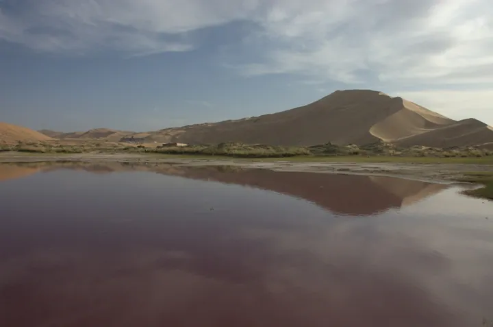
Photo adjustments
Full frame retained; proportionally resized and converted to WebP. No retouching or changes to the photographed subject. Card displays may crop the view.
- Administrative area
- Banner · 旗
- Part of
- Alxa League
- Chinese name
- 阿拉善右旗
- Local areas
- Banner guide
Area & population
- Area in the source
- 71,515.26 km²
- Population · 2020
- 22,647
- Administrative seat
- Badain Jaran
Source: cited geographic source, as of the dates shown.
Setting and landscape
The Badain Jaran is a desert of high sand mountains with 144 lakes of different sizes scattered between them. In July 2024 its 'sand mountains and lakes' were inscribed on the UNESCO World Heritage List, the first natural World Heritage site in Inner Mongolia and China's first desert site on the list. Chinese Wikipedia places the desert in Ejin Banner and Alxa Right Banner and names Bilutu Peak (必鲁图峰) as the tallest fixed dune in the world. The banner government sits in Badanjilin town (巴丹吉林镇).
History and rock art
Inner Mongolia Daily describes the banner as one of the richest areas of grassland rock art in northern China. On Mandela Mountain (曼德拉山), in the transition zone between the Badain Jaran and Tengger (腾格里) deserts, archaeologists have registered 4,234 images across about 18 square kilometres of black basalt. They are dated to five periods from the Neolithic to the Yuan, Ming and Qing, made by early tribes and by the Xiongnu, Turks, Tanguts and Mongols; the group became a national key cultural relic in 2013. Hand prints sprayed in ochre in caves of the banner's Yabrai Mountains (雅布赖山) are dated by an article in Guangming Online to the Palaeolithic, some 13,000 to 30,000 years ago.
Surveys in 2007, 2008 and 2011 found 56 ancient sites inside the desert, spanning the late Neolithic to the Song and Yuan. The banner itself was created in April 1961, when the old Alxa Banner was split into Left and Right.
Camels and local products
Herders still move their camels to winter pastures each year, and Mongolian camel-raising customs and camel racing are on the national intangible-heritage list. The banner government says its free-ranging Alxa Bactrian camels feed on saxaul, sand onion and sea buckthorn, and that their milk is relatively low in lactose, with little gamey taste; in 2026 Alxa Right Banner camel milk was named to Inner Mongolia's list of one hundred local specialty brands.
Highlights
- Badain Jaran Desert 巴丹吉林沙漠: Sand mountains with 144 lakes between them; UNESCO World Heritage site since July 2024.
- Mandela Mountain rock art 曼德拉山岩画: 4,234 registered images on basalt over about 18 sq km; national key cultural relic since 2013.
- Yabrai Mountains hand prints 雅布赖山手印岩画: Ochre hand prints sprayed on cave walls, dated to the Palaeolithic.
- Alxa Right Banner camel milk 阿拉善右旗驼奶: Named in 2026 to Inner Mongolia's list of one hundred local specialty brands.
Sources for this guide
大漠驼乡承古韵 · Inner Mongolia Daily (内蒙古日报)
大漠出珍品!阿拉善右旗驼奶成功入选内蒙古 “土特产” 百大品牌名录 · Alxa Right Banner People's Government
阿拉善岩画:写在岩壁上的叙事长诗 · Guangming Online (光明网)
巴丹吉林沙漠 · Wikipedia (Chinese) · CC BY-SA 4.0
阿拉善右旗 · Wikipedia (Chinese) · CC BY-SA 4.0
Original English written from the listed sources and checked sentence by sentence against quoted extracts by a separate reviewer. Updated 2026-09-26.
Explore Alxa Right Banner
Core places to explore, with English and Chinese names.
Places to explore around Alxa Right Banner
 AI illustration · AI
 Plan your visit
Getting there
Alxa Right Banner is about 350 km in a straight line from central Alxa League. Search for 阿拉善右旗 in a map app to find stations and your accommodation.
Where to stay →Build your route
Start with Badain Jaran Desert Scenic Area. The linked place guides have entrance and visit details.
Continue with Alxa League →More in Alxa League
Sources & geographic information
Administrative names and parent areas: Official geographic directory · Reference date 2026-09-06.
Some facts checked against 巴丹吉林沙漠 — Wikipedia contributors, CC BY-SA 4.0.
Some facts checked against 阿拉善右旗 — Wikipedia contributors, CC BY-SA 4.0.
Map data © OpenStreetMap contributors. Pins mark approximate centres, not entrances or boundaries.