


Get to know Jingjiang
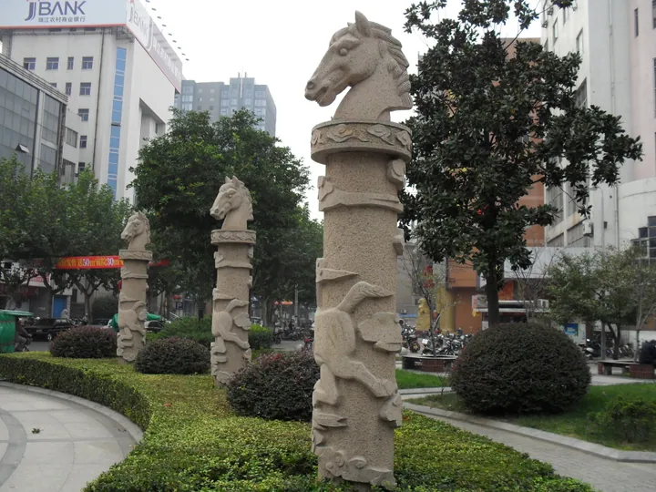
Photo adjustments
Full frame retained; proportionally resized and converted to WebP. No retouching or changes to the photographed subject. Card displays may crop the view.
- Administrative area
- County-level city · 县级市
- Part of
- Taizhou
- Chinese name
- 靖江市
- Local areas
- County-level city guide
Area & population
- Area in the source
- 665.00 km²
- Population · 2020 census
- 663,408
Source: cited geographic source, as of the dates shown.
Setting and landscape
The land was once a sandbank in the Yangtze. The city government says the river's old course ran here until it shifted south in the Eastern Han, and that silt had built dry land by the end of the Three Kingdoms, when Sun Quan (孙权), emperor of Wu, grazed horses on it. Old names for the area include Mazhou (马洲) and Jijiang (骥江). The terrain is a low, flat alluvial plain with 52.3 kilometres of Yangtze shoreline.
History
Jingjiang County was split from Jiangyin County in 1471, under the Ming. Its first magistrate, Zhang Ruhua (张汝华), built the town walls and in 1472 completed a Confucian school-temple beside the county office. Jingjiang dialect, spoken across most of the city, is a form of Wu Chinese, which makes Jingjiang one of the few places north of the Yangtze where Wu is spoken.
What to see
The old town keeps a small cluster of monuments. The Bell Tower (钟楼), built in 1569 in front of Chongsheng Temple (崇圣寺), and the Four-Eyed Well (四眼井), dug in 1637 with four eye-shaped openings, were listed together as a provincial protected site in 1995. Nearby, People's Park (人民公园) grew from the temple's garden; its Plum Blossom Pavilion (梅花阁) dates from 1838, and the Wanshou Archway (万寿坊) was rebuilt in 2003 in front of the park's south gate. The three-storey Kuixing Pavilion (魁星阁), rebuilt in 1891, is the largest surviving building among the city's provincial protected sites.
On Gushan (孤山), Gushan Temple (孤山寺) was founded in the early Tang as Zhengjian Temple (正见寺); the city government calls it Jingjiang's oldest and most influential temple. The Nieyun Archway (蹑云坊) at the southern foot of the hill served as the temple gate, and a cliff inscription beside it records a prayer for rain in 1526. Gushan also hosts a three-day temple fair around the third day of the third lunar month. In Shengci town (生祠镇), the Yue Temple (岳庙) honours Yue Fei (岳飞); the town takes its name from it.
Food and local crafts
The city's heritage lists include the making of Jingjiang crab-roe soup dumplings (靖江蟹黄汤包), Jingjiang meat jerky (靖江肉脯) and the Gushan clay dogs (孤山泥狗子). Jingjiang baojuan (靖江宝卷), a form of recited narrative text that grew out of Tang and Song storytelling, entered the national intangible-heritage list in 2008.
Highlights
- Bell Tower and Four-Eyed Well 钟楼与四眼井: Tower of 1569 and well of 1637, jointly a provincial protected site since 1995.
- Kuixing Pavilion 魁星阁: Three-storey pavilion rebuilt in 1891.
- Gushan Temple 孤山寺: Founded in the early Tang as Zhengjian Temple on Gushan.
- Jingjiang crab-roe soup dumplings 靖江蟹黄汤包: Their making is on Jingjiang's intangible-heritage lists.
- Jingjiang baojuan 靖江宝卷: National intangible heritage since 2008.
Sources for this guide
靖江现存历代文物简述 · Jingjiang Municipal People's Government
文化传统 · Jingjiang Municipal People's Government
宝卷(靖江宝卷) - 中国非物质文化遗产网 · China Intangible Cultural Heritage Network (China Intangible Cultural Heritage Protection Centre)
靖江市 - 维基百科 · Wikipedia (Chinese) · CC BY-SA 4.0
Original English written from the listed sources and checked sentence by sentence against quoted extracts by a separate reviewer. Updated 2026-09-25.
Explore Jingjiang
Core places to explore, with English and Chinese names.
Places to explore around Jingjiang
 AI illustration · AI
 Plan your visit
Getting there
Jingjiang is about 60 km in a straight line from central Taizhou. Search for 靖江市 in a map app to find stations and your accommodation.
Where to stay →Build your route
Start with Mount Gushan. The linked place guides have entrance and visit details.
Continue with Taizhou →More in Taizhou
Sources & geographic information
Administrative names and parent areas: Official geographic directory · Reference date 2026-09-06.
Some facts checked against 靖江市 — Wikipedia contributors, CC BY-SA 4.0.
Map data © OpenStreetMap contributors. Pins mark approximate centres, not entrances or boundaries.