

Photo adjustments
EXIF orientation normalized; resized without changing aspect ratio; converted to WebP. No subject edits.
Explore the region
About Mount Dajue
The cave shrine is the clearest cultural feature, while the canyon below supports the scenic area’s rafting activities. These offer quite different visits: one centres on the sheltered religious space, the other on an organised water activity. Check the available routes and conditions before combining them, especially when a canyon activity is your main reason for coming.
According to local tradition, a temple was first built in the cave as early as the Eastern Jin dynasty, when the mountain was known as Lianhua (Lotus) Mountain and the temple as Lion Rock Temple; it was later renamed after Master Dajue, abbot of Hangzhou's Lingyin Temple, said to have meditated there during the Tang dynasty. The temple has been built and destroyed multiple times, most recently rebuilt in 1985.
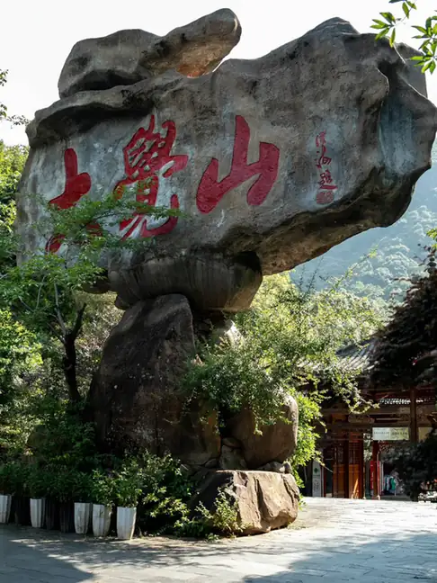
Mount Dajue's main peak reaches 1,396 metres, at the western foot of the Wuyi Mountains in Zixi County, Fuzhou. When it was rated a national 5A tourist attraction (国家5A级旅游景区) in 2017, it became the first privately run scenic area to receive that designation.
What to look for
- Dajue Temple’s rock-cave setting.
- The forested canyon landscape used for the scenic area’s rafting route.
Background & history
Mount Dajue, also known as Dajue Mountain or Dajueshan, is a mountainous area and tourist attraction in Zixi County, Fuzhou, Jiangxi, China. It is one of the AAAAA Tourist Attractions of China. Dajue Mountain tourist area's highest elevation is 1,647m, and covers an area of 204 kilometers squared. The area contains ancient forest and cultural attractions, as well as canyon activities. Dajue Peak is located in the area and has a cableway reaching 1,200m altitude, and reaches a maximum height of 1,360 meters. There is also Dajue Temple, which is a large granite cave with a total depth of 69m; the temple has a history dating back at least 1,600 years, and is located in Lotus Mountain. A leisure resort has been built within the park. The mountain has a subtropical humid monsoon climate, with an average of 1,596.7 hours of sunshine per year, an average temperature of 16.9 degrees Celsius and a rainfall of 1,929.9 mm annually. The scenic area is home to 123 rare and endangered species.
Excerpt from Wikipedia: Mount Dajue · Wikipedia contributors · CC BY-SA 4.0. Selected introductory sentences; formatting simplified. Background information, not current visitor-service advice.
Location & getting there
Getting to Mount Dajue
Use the Dajueshan scenic-area entrance at 14 Jianshe East Road in Zixi County. Confirm the internal transfer and ascent for the cave temple separately from arrangements for rafting.
Combine your visit
A suggested sequence linking the specific features of this visit.
-
Dajue cave temple
Begin with the religious space enclosed by the mountain rock.
-
Canyon visitor area
See the lower forest-and-water landscape, joining an organised activity only if suitable and operating.
This order is editorial. Confirm access and any transfers between stops; it does not establish a walking route, same-day connection or common admission ticket.
Find Mount Dajue
大觉山 · 抚州市
The pin marks the area, not the entrance.
More places nearby
Approximate straight-line distances between map pins, not travel distances.
Shangqing, Jiangxi 上清古镇
40 km awayShangqing’s old-town visit centres on the Celestial Master’s Mansion, the traditional residence and ritual complex of the Zhang lineage of Daoist masters. Its sequence places ceremonial halls towards the front and residential…
View guide →Longhu Mountain 龙虎山
46 km awayLonghu Mountain combines red sandstone cliffs with a river landscape and the religious centres of Zhengyi Daoism. Around Xianshuiyan, cavities in the cliff faces are associated with ancient suspended burials; in Shangqing, the…
View guide →Guifeng 龟峰
73 km awayGuifeng near Yiyang is named for rock formations that resemble turtles. Its Danxia landscape includes clusters of peaks, isolated pillars, natural bridges and caves.
View guide →Sources & visit information
The sources below support the place-specific description and arrival information. Suggested combinations are editorial planning ideas; confirm current opening, entry arrangements and transport services for your date.
- Mount Dajue ↗
- www.amap.com ↗
- www.jxfz.gov.cn ↗
- Chinese Wikipedia: 大觉山 (revision 79200269, 2023-10-03) ↗
- English Wikipedia: Mount Dajue (revision 1353315149, 2026-05-09) ↗
Visitor information adapted and edited from Wikipedia contributors, “Mount Dajue” · CC BY-SA 4.0. Source revision 1353315149.
Background paragraphs translated and condensed from Wikipedia contributors, "大觉山", Chinese Wikipedia · CC BY-SA 4.0. Source revision 79200269.
Background paragraphs condensed from Wikipedia contributors, "Mount Dajue", English Wikipedia · CC BY-SA 4.0. Source revision 1353315149.