


Get to know Yitong Manchu Autonomous County
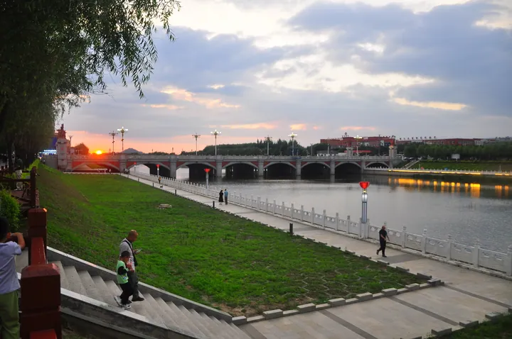
Photo adjustments
Full frame retained; proportionally resized and converted to WebP. No retouching or changes to the photographed subject. Card displays may crop the view.
- Administrative area
- Autonomous county · 自治县
- Part of
- Siping
- Chinese name
- 伊通满族自治县
- Local areas
- Autonomous county guide
Area & population
- Area in the source
- 2,523.00 km²
- Population · 2020 census
- 331,873
- Administrative seat
- Yongning Subdistrict
Source: cited geographic source, as of the dates shown.
Setting and landscape
The county lies in the hill country where the Changbai Mountains (长白山脉) give way to the Songliao Plain (松辽平原). Low hills of the Jilin Hada Range (吉林哈达岭) in the southeast and the Dahei Mountains (大黑山) in the northwest cover about 60 percent of the land, while the centre and west are river plains that tilt from south to north. The highest point, Qingding Mountain (青顶山) at 611 metres, is where the Yitong River rises.
Sixteen volcanoes stand in two rows along the southern end of the Yilan–Yitong fault. They formed in the Miocene, have no clear craters and are built mostly of columnar alkaline olivine basalt. Seven of them are laid out like the Big Dipper, giving the county the nicknames "Seven Star Mountains" (七星山) and "land where the seven stars fell". Jilin made the group a provincial nature reserve in December 1984, and the State Council raised it to a national nature reserve on 27 October 1992.
What to see
Dagushan (大孤山), 413 metres and the first of the seven, has four peaks: one of upright basalt columns called the "pagoda forest", one shaped like a turtle, one like an elephant, and a broad summit that once carried a Taoist temple, the Qingyun Temple (青云观). Xijianshan (西尖山), 4 kilometres northwest of the county town, rises straight from the plain in five- and six-sided columns 30 to 50 centimetres across; the county government compares it with Devils Tower in Wyoming.
The Yitong Manchu Museum (伊通满族博物馆) began in 1987 as a folk-custom hall and moved in 2001 to a five-storey building in late-Qing style. It holds 6,638 Manchu heirlooms and folk objects, shown in six halls on Manchu origins, politics, economy, culture and customs, and on Yitong past and present. It is a national 4A tourist site and a grade-three national museum. Yimao Street (一毛街) in the county town is locally known for barbecue.
History
The name comes from the river and renders a Manchu word for a vast, surging river. At the end of the Ming dynasty most of the area belonged to the Yehe (叶赫部) branch of the Haixi Jurchens (海西女真). The Qing placed a sub-inspector on the Yitong River in 1814 and raised the post to Yitong Department (伊通州) in 1882; it became a county in 1913. Under Manchukuo it was merged with Shuangyang (双阳) in 1941 as Tongyang County (通阳县), and the two were separated again in March 1946.
Highlights
- Yitong volcano group 伊通火山群: Sixteen Miocene basalt volcanoes; national nature reserve since 27 October 1992.
- Dagushan 大孤山: First of the 'Seven Star Mountains', 413 m, with four peaks including a 'pagoda forest' of basalt columns.
- Xijianshan 西尖山: Columnar basalt cone 4 km northwest of the county town.
- Yitong Manchu Museum 伊通满族博物馆: 6,638 Manchu heirlooms and folk objects in six halls; national 4A tourist site.
- Yimao Street 一毛街: Locally known barbecue street in the county town.
Sources for this guide
伊通满族自治县 - 维基百科,自由的百科全书 · Chinese Wikipedia · CC BY-SA 4.0
自然概况 · Yitong Manchu Autonomous County People's Government
伊通满族自治县博物馆 · Yitong Manchu Autonomous County People's Government (county culture, radio, television and tourism bureau)
Original English written from the listed sources and checked sentence by sentence against quoted extracts by a separate reviewer. Updated 2026-09-25.
Explore Yitong Manchu Autonomous County
Core places to explore, with English and Chinese names.
Places to explore around Yitong Manchu Autonomous County
 AI illustration · AI
 Plan your visit
Getting there
Yitong Manchu Autonomous County is about 80 km in a straight line from central Siping. Search for 伊通满族自治县 in a map app to find stations and your accommodation.
Where to stay →Build your route
Start with Yitong Manchu Museum. The linked place guides have entrance and visit details.
Continue with Siping →More in Siping
Sources & geographic information
Administrative names and parent areas: Official geographic directory · Reference date 2026-09-06.
Some facts checked against 伊通满族自治县 — Wikipedia contributors, CC BY-SA 4.0.
Map data © OpenStreetMap contributors. Pins mark approximate centres, not entrances or boundaries.