


Get to know Hongsibu District
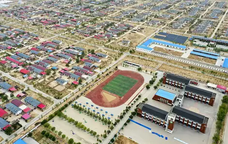
Photo adjustments
EXIF orientation normalized; resized without changing aspect ratio; converted to WebP. No subject edits.
- Administrative area
- District · 市辖区
- Part of
- Wuzhong
- Chinese name
- 红寺堡区
- Local areas
- District guide
Area & population
- Area in the source
- 3,523.09 km²
- Population · 2020 Census
- 197,604
- Administrative seat
- Hongsibu Town
Source: cited geographic source, as of the dates shown.
Setting and landscape
The ground rises from north to south, at 1,240 to 1,450 metres, in the core of Ningxia's central dry belt. Chinese Wikipedia gives 203 millimetres of rain a year against evaporation of 2,050 millimetres, and the area has no surface or ground water for irrigation. Yellow River water is lifted through three stages of pumping stations to reach the higher ground, and the district government gives 2,900 to 3,550 hours of sunshine a year.
History
The district government names the Tiezhuang site (铁庄遗址) as a Neolithic settlement. In 672 the Tang emperor Gaozong settled the Tuyuhun (吐谷浑) people and Princess Honghua (弘化公主) at Hongchengshui (红城水) at the foot of Luoshan, where she lived for 39 years. The name comes from a Sui-dynasty temple called Hongfo Temple (弘佛寺): its short form (弘寺) gradually became "红寺" (red temple), and the Ming dynasty built a fort (堡) here.
In 1994 Qian Zhengying (钱正英) proposed lifting Yellow River water onto the dry plains and moving mountain families to the new irrigated land. Work on the Hongsibu irrigation area began in September 1998, settlers came from counties such as Tongxin (同心), Haiyuan (海原), Xiji (西吉) and Longde (隆德), and the State Council approved the district in October 2009.
What to see
Luoshan (罗山), 25 kilometres from the district, is a temperate forest surrounded by desertified land, which the district government calls the only natural water-conservation forest in Ningxia's central dry belt. Its spring greenery was known as "Luoshan Diecui" (罗山叠翠, layered green of Luoshan), one of the Eight Views of Ningxia. Golden eagles and lynx live here, and it became a national nature reserve in 2002. The Ningxia Migration Museum (宁夏移民博物馆) on Wenhua Street opened in September 2013 and covers the region's ethnic cultures and the resettlement programme; it is a national 3A tourist site. The district government also lists the Yunqing Temple (云青寺) and the Luoshan model-aircraft flying camp; the district has hosted national youth aeromodelling championships for years.
Food and local products
The resettled farms grow wine grapes, daylilies (黄花菜) and goji, and raise beef cattle and Tan sheep (滩羊). Hongsibu has been named "China's first wine town" (中国葡萄酒第一镇) and a star production area for selenium-rich daylilies.
Getting oriented
Yinchuan (银川) is 127 kilometres to the north and Guyuan (固原) 196 kilometres to the south. The Beijing–Tibet and Yinchuan–Kunming expressways cross the district, as do the Taiyuan–Zhongwei–Yinchuan railway and the Yinchuan–Xi'an high-speed railway.
Highlights
- Luoshan National Nature Reserve 罗山: Temperate forest island in the central dry belt; a national nature reserve since 2002.
- Ningxia Migration Museum 宁夏移民博物馆: Opened in September 2013 on Wenhua Street; tells the story of the resettlement programme.
- Yunqing Temple 云青寺: Named by the district government among its Buddhist and Taoist sites.
- Hongsibu wine grapes 酿酒葡萄: Hongsibu has been named China's first wine town.
Sources for this guide
红寺堡区 - 维基百科,自由的百科全书 · Chinese Wikipedia · CC BY-SA 4.0
红寺堡区基本概况_红寺堡区人民政府 · Hongsibu District People's Government
罗山_红寺堡区人民政府 · Hongsibu District People's Government
移民博物馆_红寺堡区人民政府 · Hongsibu District People's Government
Original English written from the listed sources and checked sentence by sentence against quoted extracts by a separate reviewer. Updated 2026-09-26.
Explore Hongsibu District
Core places to explore, with English and Chinese names.
Hongsibu District 红寺堡区
Plan your visit
Getting there
Hongsibu District is about 75 km in a straight line from central Wuzhong. Search for 红寺堡区 in a map app to find stations and your accommodation.
Where to stay →More in Wuzhong
Sources & geographic information
Administrative names and parent areas: Official geographic directory · Reference date 2026-09-06.
Some facts checked against 红寺堡区 — Wikipedia contributors, CC BY-SA 4.0.
Map data © OpenStreetMap contributors. Pins mark approximate centres, not entrances or boundaries.