


Photo adjustments
Proportionally resized and converted to WebP without cropping, retouching or changing the photographed subject.
Explore the region
About Nanhaizi Park
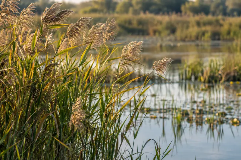
Milu Yuan gives the area its close association with Père David’s deer, while reed beds and open water provide a broader birdwatching setting. Nanyou Qiufeng and Wangyuan Pavilion connect the present park with its older landscape identity. Plan a route that combines the deer-conservation area with a waterside section, checking the sanctuary’s own access separately. Wildlife sightings vary, so the wetland landscape remains the foundation of the visit even when animals are not close to the viewing areas.
Nanhaizi Park takes its name from lying within Nanyuan (南苑), the Ming and Qing imperial garden known in the Ming as Nanhaizi. After the People's Liberation Army entered the area in December 1948, and following the State Council's 1958 decision to return Daxing County to Beijing from Hebei, Nanyuan was divided among three districts: its southern farmland and several townships went to Daxing, its northern part to Fengtai, and Xiaohongmen in the northeast to Chaoyang. On 24 August 1985, the first twenty-two Milu deer (麋鹿) were returned from Wubangsi Zhuangyuan (乌邦寺庄园) in England to their original habitat at what became the Nanhaizi Milu Yuan (南海子麋鹿苑).
The park lies along the southern extension of Beijing's central axis, within a planned area bounded by the Liangshui River (凉水河) to the east, National Highway 104 to the west, the South Fifth Ring Road to the north and Huangyi Road to the south, covering 8.01 square kilometers of which 240 hectares is wetland. Construction of the Sanhaizi Suburban Park (三海子郊野公园) began on 16 January 2010, and the first phase, covering 159.64 hectares in the southeastern part of the planning area with five scenic areas and sixteen scenic spots, opened to the public on 26 September 2010.
What to look for
- Milu Yuan setting: learn about Père David’s deer and their connection with the former imperial grounds.
- Wetlands and lake margins: look for the transition between reed beds, open water, and woodland.
- Wangyuan Pavilion: use the viewpoint to read the wider wetland landscape.
Location & getting there
Getting to Nanhaizi Park
The municipal guide identifies the North Gate or South Gate parking lots as driving destinations. Its deer-focused route begins from the North Gate, crosses the stone bridge, and follows the reed boardwalk toward Milu Yuan.
- The deer sanctuary has its own closure arrangements, so check it separately from the wider park before planning the visit around it.
Combine your visit
Suggested order within this visit:
-
Milu Yuan
Start with the deer-conservation setting if it is open.
-
Wangyuan Pavilion
Read the park’s broad wetland form from the viewpoint.
-
Reed-lined water margins
Finish with quiet observation of the habitat rather than a guaranteed animal encounter.
This sequence is an editorial suggestion based on the features described in the sources. Access to individual buildings or areas should be checked locally; no travel time or shared admission is implied.
Find Nanhaizi Park
南海子公园 · 大兴区
The pin marks the area, not the entrance.
More places nearby
Approximate straight-line distances between map pins, not travel distances.
China Printing Museum 中国印刷博物馆
12 km awayChina Printing Museum in Daxing traces how texts moved from handwriting and carved forms toward printing technologies. Its displays include printing equipment and printed material, with interpretation of papermaking and a…
View guide →Temple of Heaven 天坛
12 km awayThe Temple of Heaven combines imperial ritual architecture with a large wooded park southeast of Beijing’s old central axis. Its main sequence links the Hall of Prayer for Good Harvests with the Imperial Vault of Heaven and the…
View guide →Taoranting Park 陶然亭公园
13 km awayTaoranting Park combines a lakeside public garden with an older literary and religious setting in southern Beijing. Its name comes from Taoran Pavilion, associated with gatherings of scholars and a poem by Bai Juyi, while Cibei…
View guide →Sources & visit information
The sources below support the place-specific description and arrival information. Suggested combinations are editorial planning ideas; confirm current opening, entry arrangements and transport services for your date.
- Nanhaizi wetland route, named features, and gates ↗
- Nanhaizi Park Greenway ↗
- Chinese Wikipedia: 南海子公园 (revision 93693943, 2026-07-29) ↗
Background paragraphs translated and condensed from Wikipedia contributors, "南海子公园", Chinese Wikipedia · CC BY-SA 4.0. Source revision 93693943.