

Photo adjustments
Proportionally resized and converted to WebP without cropping, retouching or changing the photographed subject.
Explore the region
About Dianchi Lake
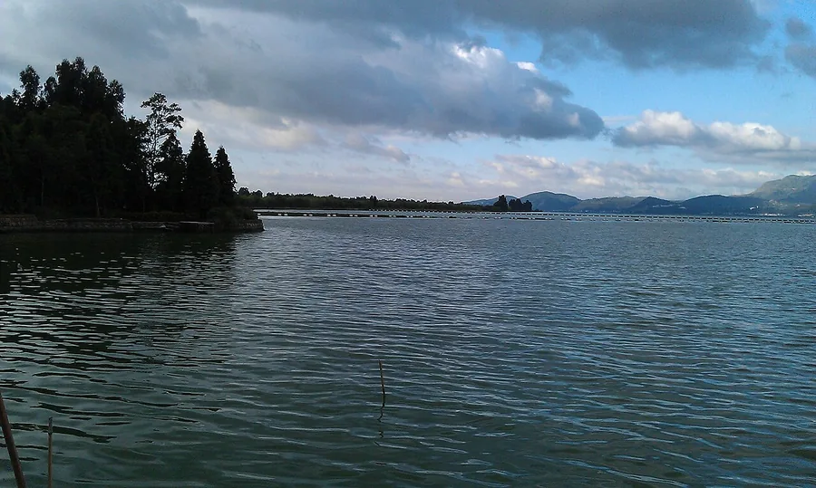
The northern shore is the easiest place to make a focused visit: Haigeng Park brings you to the lake edge, while Guanjing Road offers an extended view towards the hills. Winter can bring visiting gulls, but the lake and mountain panorama remain the main reason to come in other seasons. Choose a shore section rather than treating this large lake as one walkable attraction.
The lake formed in a tectonic depression. About 30,000 years ago it drained towards the Honghe River (红河) through Citong Pass (刺铜关). Uplift at the pass and subsidence along the Haikou River (海口河) subsequently changed its drainage towards the Jinsha River (金沙江). The lake now receives twenty-nine natural inflowing rivers, with the Panlong River (盘龙江) providing its principal inflow.
Accumulated sediment formed a barrier dividing the northern Caohai (草海) from the much larger southern Waihai (外海). Completion of the Xiyuan Tunnel (西园隧洞) in 1996 gave Caohai a separate outlet, making the two waters independent lake areas. The basin has a subtropical monsoon climate with distinct wet and dry seasons; most rainfall occurs from May to October. Dianchi is designated a National Key Scenic Area (国家级重点风景名胜区).
What to look for
- Haigeng Park opens onto the northern lake shore.
- Guanjing Road frames the water against the Western Hills; gulls are a seasonal sight.
Background & history
Dian Lake (Chinese: 滇池; pinyin: Diānchí), also known as Dianchi, Dianchi Lake, Lake Dian and Kunming Lake, is a fault lake located on the Puduhe-Xishan fault in Kunming, Yunnan, China at 24°23′–26°22′ N, 102°10′–103°40′ E. Its nickname is the "Sparkling Pearl Embedded in a Highland" (Chinese: 高原明珠; pinyin: Gāoyuánmíngzhū). It is the model for the Kunming Lake in Beijing's Summer Palace. Its name is the source of Yunnan's Chinese abbreviation 滇. Dian Lake is a shallow freshwater fault lake. The Lake is 40 km long, running from north to south, and has an average width of 7 km with the widest point being 12.5 km. The lake is 1886 meters above sea level and has 150 km of coastline. The lake's drainage area has a monsoon-affected subtropical highland climate (Köppen Cwb), with an average annual temperature of 14.4 °C, a frost-free period of 227 days, and an annual precipitation of 1036 mm. The lake covers 298 km2 (115 sq mi).
Excerpt from Wikipedia: Dian Lake · Wikipedia contributors · CC BY-SA 4.0. Selected introductory sentences; formatting simplified. Background information, not current visitor-service advice.
Location & getting there
Getting to Dianchi Lake
For the north shore, arrange your local journey to Haigeng Park or Guanjing Road (观景路). These are specific shore destinations in Kunming; a map result for the middle of Dianchi does not describe a visitor entrance.
Combine your visit
Suggested order for the visit:
-
Haigeng Park
Begin with the lake-edge park.
-
Guanjing Road shore
Continue the outing with another view of the Western Hills.
This is an editorial sequence of named spaces or places. It does not imply a verified walking connection or promise opening, ticket availability or a journey time.
Find Dianchi Lake
滇池 · 昆明
The pin marks the area, not the entrance.
More places nearby
Approximate straight-line distances between map pins, not travel distances.
Yunnan Nationalities Museum 云南民族博物馆
19 km awayYunnan Nationalities Museum presents the region’s communities through dress, personal ornaments, craft, art and written material. The objects offer a useful foundation before visiting villages elsewhere in Yunnan, especially…
View guide →Western Hills 西山
19 km awayKunming’s Western Hills rise above Dianchi with forested slopes, temple gardens and a cliff-side religious landscape. Huating and Taihua temples offer courtyards and planting on the ascent, while Dragon Gate and Sanqing Pavilion…
View guide →Green Lake 翠湖
28 km awayGreen Lake is a city park of water, causeways and pavilions in central Kunming. The north–south Ruan Causeway and east–west Tang Causeway help divide the water into smaller scenes, bringing changing views of willow-lined banks…
View guide →Sources & visit information
The sources below support the place-specific description and arrival information. Suggested combinations are editorial planning ideas; confirm current opening, entry arrangements and transport services for your date.
Visitor information adapted and edited from Wikipedia contributors, “Dian Lake” · CC BY-SA 4.0. Source revision 1373293163.
Visitor information adapted and edited from Wikivoyage contributors, Kunming · CC BY-SA 4.0. Source revision 5298360.
Background paragraphs translated and condensed from Wikipedia contributors, "滇池", Chinese Wikipedia · CC BY-SA 4.0. Source revision 90909820.