


Get to know Gangca County
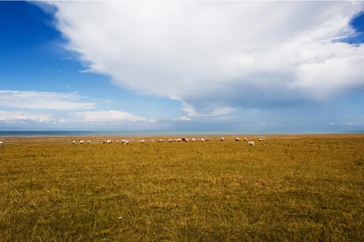
Photo adjustments
Full frame retained; proportionally resized and converted to WebP. No retouching or changes to the photographed subject. Card displays may crop the view.
- Administrative area
- County · 县
- Part of
- Haibei Tibetan Autonomous Prefecture
- Chinese name
- 刚察县
- Local areas
- County guide
Area & population
- Area in the source
- 9,575.91 km²
- Population · 2020
- 40,720
- Administrative seat
- Shaliuhe
Source: cited geographic source, as of the dates shown.
Setting and landscape
Gangca has a dry high-plateau climate with long, severe winters, short cool summers and most of its rain in summer; the China Meteorological Administration figures cited by Wikipedia give a January mean of -13.5°C, a July mean of 10.9°C and about 380 millimetres of rain a year. Qinghai Lake's wetlands, of which Xiannü Bay in Gangca is an important part, were listed as internationally important in 1992.
What to see
The Shaliu River Naked Carp Home (沙柳河湟鱼家园景区), 2 kilometres from the county town, is where the Qinghai Lake naked carp (青海裸鲤), known locally as huangyu (湟鱼), swim upriver to spawn in June and July. In the shallows their dorsal fins break the surface like a fleet of sails, and the Haibei government describes the spawning stretch as 'half river water, half river fish' and calls it the only place in China to watch the carp's migration. A fish-release festival is held in Gangca in the same months.
Xiannü Bay (青海湖仙女湾景区), 16 kilometres from the county town at about 3,200 metres, is a meadow wetland where flocks of whooper swans rest in autumn and winter, and it also presents the local lake-worship tradition.
Nianqin Xiagri Mountain (年钦夏格日山, 4,385 metres) stands on the border with Haiyan (海晏) and is one of Gangca's three sacred mountains. Its Tibetan name describes an all-powerful, handsome white-faced mountain god, and legend makes it a dwelling of the Queen Mother of the West (西王母). On the summit a stone pillar more than 3 metres high rings like metal when struck, and the Kunlun Shrine (昆仑神祠) at its foot holds a statue of the Queen Mother and 13 murals.
At Tangqu village (塘渠村) in Hargai town (哈尔盖镇), 28 kilometres from the county town, a Przewalski's gazelle (普氏原羚) education base has a nine-storey lookout tower. Hargai, named China's home of the Przewalski's gazelle in 2017, is where the gazelle is most densely distributed, and it is known as the birthplace of 'Looking up at the Stars in Hargai', the poem that made the poet Xichuan (西川) famous.
Highlights
- Shaliu River Naked Carp Home 沙柳河湟鱼家园景区: Naked carp run upriver to spawn in June and July, 2 km from the county town.
- Xiannü Bay 青海湖仙女湾景区: Qinghai Lake wetland where whooper swans winter.
- Nianqin Xiagri Mountain 年钦夏格日山: Sacred 4,385 m mountain linked with the Queen Mother of the West; ringing stone pillar on the summit.
- Przewalski's gazelle base, Hargai 普氏原羚科普研学基地: Hargai, named China's home of the Przewalski's gazelle in 2017, has the gazelle's densest range; the base has a nine-storey lookout tower.
Sources for this guide
刚察县 - 维基百科,自由的百科全书 · Chinese Wikipedia · CC BY-SA 4.0
【藏城刚察】青海湖裸鲤放流增殖暨观鱼放生节 · Haibei Tibetan Autonomous Prefecture People's Government (Culture, Sports and Tourism Bureau)
【藏城刚察】沙柳河湟鱼家园景区 · Haibei Tibetan Autonomous Prefecture People's Government
【藏城刚察】年钦夏格日山 · Haibei Tibetan Autonomous Prefecture People's Government
【藏城刚察】青海湖仙女湾景区 · Haibei Tibetan Autonomous Prefecture People's Government
【藏城刚察】普氏原羚科普研学基地 · Haibei Tibetan Autonomous Prefecture People's Government
Gangca County - Wikipedia · English Wikipedia · CC BY-SA 4.0
Original English written from the listed sources and checked sentence by sentence against quoted extracts by a separate reviewer. Updated 2026-09-26.
Explore Gangca County
Core places to explore, with English and Chinese names.
Places to explore around Gangca County
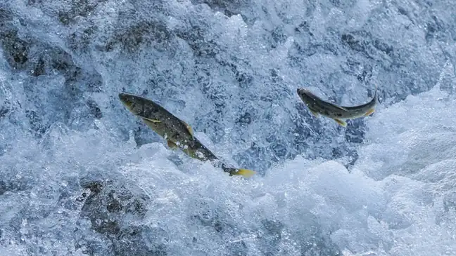 Naked Carp Migration Viewing Area ·
 Plan your visit
Getting there
Gangca County is about 80 km in a straight line from central Haibei Tibetan Autonomous Prefecture. Search for 刚察县 in a map app to find stations and your accommodation.
Where to stay →Build your route
Start with Naked Carp Migration Viewing Area. The linked place guides have entrance and visit details.
Continue with Haibei Tibetan Autonomous Prefecture →More in Haibei Tibetan Autonomous Prefecture
Sources & geographic information
Administrative names and parent areas: Official geographic directory · Reference date 2026-09-06.
Some facts checked against 刚察县 — Wikipedia contributors, CC BY-SA 4.0.
Some facts checked against Gangca County — Wikipedia contributors, CC BY-SA 4.0.
Photo: Naked Carp Migration Viewing Area · Source photographer · License not provided. EXIF orientation normalized; resized without changing aspect ratio; converted to WebP. No subject edits.
Map data © OpenStreetMap contributors. Pins mark approximate centres, not entrances or boundaries.