

Entry & permits for Tibet (Xizang)
Foreign tourists need Tibet entry approval, commonly called a Tibet Travel Permit, and an organised visit arranged through a specialist travel agency in China. Confirm your approved route before booking transport. Requirements differ for Taiwan residents and for travellers using mainland or Hong Kong/Macao Chinese resident documents; check the document guide before you book.
Check the travel-document requirements →Policy scope verified: 2026-09-06. UK FCDO: China regional travel advice ↗ State Council Taiwan Affairs Office: Tibet entry approval ↗ Xizang Department of Culture and Tourism: Medog border permit notice ↗
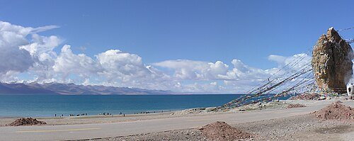
Photo adjustments
Wikimedia thumbnail; fitted to the ranking-card frame.
Explore the region
About Namtso
Its exposed water, distant snow peaks and rocky shore give it a very different character from Tibet’s river valleys. At the southeastern corner, Tashi Dor combines a monastery with the lake’s long pilgrimage tradition. This is a sensible focus for a first shore visit rather than an attempt to cover the whole lake. Weather can change abruptly around the mountain crossing and the water, so keep the route flexible and stay on established visitor paths.
Ancient shoreline traces indicate that the lake was formerly wider and deeper. Continued plate collision through the Quaternary raised the Tibetan plateau and dried the climate, shrinking the lake; three tiers of ancient shoreline remnants now surround Namtso, one of them standing 80 metres above the present water level.
Namtso lies in the Qinghai-Tibet plateau lake region, on the boundary between Baingoin county (班戈县) of Nagqu (那曲市) and Damxung county (当雄县) of Lhasa, about 100 kilometres north of Lhasa; roughly three-fifths of its surface lies in Baingoin and two-fifths in Damxung. Nearly rectangular, it extends over 70 kilometres east-west and over 30 kilometres north-south, covering more than 1,920 square kilometres, with an average depth of 33 metres.
The lake has five uninhabited islands and one or two rocky outcrops. Pilgrims once walked across the frozen surface at the end of winter to spend the summer on the islands in spiritual retreat, a practice no longer permitted by the Chinese authorities. An island in the northwest corner is about 2,100 metres long and 800 metres wide, rising just over 100 metres, and lies about 3.1 kilometres from shore.
What to look for
- The southeastern Tashi Dor shore, where the monastery and rock formations meet the lake.
- The open saline water and mountain skyline of the Nyainqentanglha range.
The surrounding area
Palaces, monasteries, museums and a working old city with a strong tea-house culture.
Location & getting there
Getting to Namtso
For the southeastern visitor area, use the road from Damxung across Laken/La Gen La Pass towards Tashi Dor.
- Confirm the open road and visitor access before setting out; the pass and lakeshore are exposed to sudden weather changes.
Combine your visit
Suggested order for this visit:
-
Tashi Dor arrival area
Begin at the established southeastern shore.
-
Monastery and rocky shore
Connect the pilgrimage setting with the lake landscape.
-
Accessible lakeside viewpoint
Finish with the mountain horizon without planning a full lake circuit.
This is an editorial sequence based on the features described in the sources. Confirm access locally; no walking time, shared admission or guaranteed interior access is implied.
Find Namtso
纳木错 · 拉萨
The pin marks the area, not the entrance.
More places nearby
Approximate straight-line distances between map pins, not travel distances.
Nyainqentanglha Mountains 念青唐古拉山
37 km awayThe Nyainqentanglha range separates the high interior plateau from river systems draining towards the Yarlung Tsangpo. Its western peaks rise beside Namtso and Damxung, with snowy ridges visible from the Yangbajing grasslands…
View guide →Pabongka Monastery 帕邦喀寺
122 km awayPabongka takes its name from the enormous rock supporting its temple buildings on Lhasa's northern hillside. The complex combines the Rigsum Gonpo shrine at the front, the upper Pabonka Potrang and a building traditionally…
View guide →Drepung Monastery 哲蚌寺
123 km awayDrepung spreads across the foot of Mount Gephel west of Lhasa, its white monastic buildings giving substance to the name ‘Rice Heap’. Founded in 1416, it grew through colleges with distinct teaching traditions. The Ganden…
View guide →Sources & visit information
The linked encyclopedia sources support background and place descriptions. Current opening hours, ticket prices, booking rules and transport schedules have not been independently verified for this guide. Confirm them with the venue or operator before travelling.
- Wikipedia: Namtso ↗
- Chinese Wikipedia: 纳木错 (revision 92973038, 2026-06-06) ↗
- English Wikipedia: Namtso (revision 1366464011, 2026-07-28) ↗
Visitor information adapted and edited from Wikipedia contributors · CC BY-SA 4.0. Source revision 1366464011.
Background paragraphs translated and condensed from Wikipedia contributors, "纳木错", Chinese Wikipedia · CC BY-SA 4.0. Source revision 92973038.
Background paragraphs condensed from Wikipedia contributors, "Namtso", English Wikipedia · CC BY-SA 4.0. Source revision 1366464011.