

Entry & permits for Tibet (Xizang)
Foreign tourists need Tibet entry approval, commonly called a Tibet Travel Permit, and an organised visit arranged through a specialist travel agency in China. Confirm your approved route before booking transport. Requirements differ for Taiwan residents and for travellers using mainland or Hong Kong/Macao Chinese resident documents; check the document guide before you book.
Check the travel-document requirements →Policy scope verified: 2026-09-06. UK FCDO: China regional travel advice ↗ State Council Taiwan Affairs Office: Tibet entry approval ↗ Xizang Department of Culture and Tourism: Medog border permit notice ↗
Explore the region
Why this landscape is worth your time
The Niyang River (娘曲) is the principal river associated with the Gongbu region and a major northern-bank tributary of the Yarlung Zangbo. The Ministry of Ecology and Environment gives the river as 307.5 km long, with a 15,459 sq km basin and annual runoff of 22 billion cubic metres; those figures describe the whole river, not a single viewpoint.
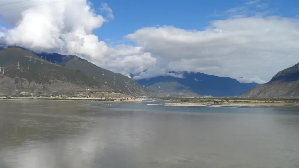
The most legible scene is near the meeting of the Niyang and Yarlung Zangbo: wide water, wooded sandbars and two currents that the Bayi district describes as remaining visibly distinct. The district’s tourism page places the confluence 8 km from Bangna (帮纳), while the city tourism bureau describes the adjoining Yani National Wetland Park as a broad delta wetland in Bayi and Milin. Read this as a river landscape with several viewing contexts, not as one park boundary.
What to look at
Start with the shape of the water. From a safe, signed viewpoint, look for the change from a narrower river channel to the wider confluence and compare the tones and movement of the two waters. Then look outward: the official wetland description highlights looping water, tree-covered sandbars, dense vegetation and autumn colour. These details make the place more rewarding than a quick photograph from a moving vehicle.
The river is also an ecological subject. The national case study says the basin remains generally healthy but fragile, with uneven water distribution and pressures including riverbank vegetation loss, glacier retreat, grassland degradation and soil erosion. It records Class II water quality at the nationally monitored section and fish species that include protected or endemic plateau fish. That is a reason to keep to established banks, avoid entering the water and leave the wetland edge undisturbed; it is not a promise that visitors will see fish from the shore.
Scope, facilities and what is not confirmed
“尼洋河风光” is a landscape label. The official Bayi description combines the river, the confluence, Bangna village and other nearby attractions under a scenic belt, while the city tourism page separately identifies Yani National Wetland Park. I have therefore not treated every river view as the same paid park, and I have not invented one gate, ticket, opening schedule, boat ride or walking loop. Confirm the specific viewpoint or managed wetland facility you intend to visit on your date.
If you are following a tour route to the Yarlung Zangbo Grand Canyon, the Yani wetland is described by the city tourism bureau as lying on the way from Nyingchi’s urban area toward the canyon. That relationship does not prove that every roadside stop has the same access or facilities.
Getting there
For a practical visit, arrange a road transfer from Bayi or Nyingchi city to a confirmed confluence or wetland viewpoint. Show the driver the Chinese destination and the exact entrance supplied by your hotel or tour operator; “尼洋河风光” alone can refer to a wide area. The district source’s useful geographic anchor is “尼洋河与雅鲁藏布江交汇处” near 帮纳, not a verified universal entrance.
Nyingchi Railway Station (林芝站) is an operating passenger station on the Lhasa–Nyingchi railway. It is a regional arrival point, not a station at the river, so continue by road and arrange the return before leaving town. The current rail report confirms passenger service to Nyingchi but does not publish a direct bus, shuttle or last-mile route for this landscape. No metro route or reliable public-bus relationship to a specific Niyang River viewpoint was confirmed for this entry.
Visitors travelling on a foreign passport should arrange the Tibet travel permit and organised route through a specialist travel agent before booking this stop. The UK Foreign, Commonwealth & Development Office warns that permits can stop being issued or regional access can be restricted without notice. Ask the operator to put the intended Nyingchi/Bayi stop and the actual wetland or confluence entrance on the approved itinerary; do not assume that a domestic-ID procedure or a generic city booking covers a foreign visitor.
Before you go
Weather and river conditions can change the usefulness of an exposed viewpoint. Confirm the day’s access, any managed-area ticket or reservation, the road drop-off point and the return vehicle. Stay on marked paths or public viewpoints, ask before photographing religious activity, and do not climb unstable banks or approach the current.
Find Niyang River Scenery
尼洋河风光 · 巴宜区
No reliable map pin yet: search by the Chinese name.
Sources & visit information
Sources checked on 1 November 2026. Hours, tickets, reservations and transport can change; confirm with the operator before you go.
Image credits & notes (1)
- The Niyang–Yarlung Tsangpo confluence, seen as broad water and sandbars between mountain slopes (photographed 3 October 2019). Photo: 钉钉 (Wikimedia Commons user 钉钉)Photo: CC BY-SA 4.0