


Get to know Bayi District
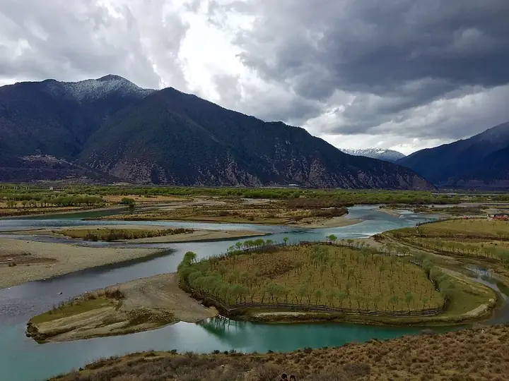
Photo adjustments
Full frame retained; resized proportionally to a maximum dimension of 960 pixels and converted to WebP quality 88. No crop, retouch, generated elements, or subject alteration. Final website rendition: full frame retained, proportionally resized to at most 720 pixels and converted to WebP. No additional retouching or subject alteration. Card displays may crop the view.
- Administrative area
- District · 市辖区
- Part of
- Nyingchi
- Chinese name
- 巴宜区
- Local areas
- District guide
Area & population
- Area in the source
- 8,558.23 km²
- Population · 2020
- 84,254
Source: cited geographic source, as of the dates shown.
Setting and landscape
The district lies on the north bank of the Yarlung Tsangpo and on the lower Nyang River. The Nyang, which the Kongpo (工布) people call their mother river, is 307.5 km long and one of the five main tributaries of the Yarlung Tsangpo; it enters the main river at Liding village (立定村) in Nyingchi Town (林芝镇). The Kongpo people also call it the Nyang Chu (娘曲), Tibetan for "tears of the goddess".
History
Nyingchi County was formed in September 1959 by merging three dzongs (宗, Tibetan districts), and it came under the new Nyingchi Prefecture in 1986. The county government moved from Nyingchi Town to Bayi Town (八一镇) on 9 October 2005. In March 2015, when Nyingchi became a prefecture-level city, the county was turned into Bayi District.
What to see
Two monasteries are in the district: Buchu, some 28 km south of Bayi Town, and Lamaling, in Puqu Township. North of the Yarlung Tsangpo rises Benri mountain, a holy site of the Bon religion; seven Bon temples were built around it, and pilgrims come to circle it during the Saga Dawa festival.
Getting oriented
Bayi Town is the seat of the Nyingchi city government. The district government puts the district about 400 km from Lhasa and about 50 km from Nyingchi Airport, and the Sichuan–Tibet road, National Highway 318, and Provincial Highway 306 cross it. The Lhasa–Nyingchi railway opened in 2021, with Nyingchi Station (林芝站) in Bujiu Township (布久乡).
Highlights
- Nyang River 尼洋河: The Kongpo 'mother river', 307.5 km long, joining the Yarlung Tsangpo in the district.
Sources for this guide
巴宜区 - 维基百科,自由的百科全书 · Chinese Wikipedia · CC BY-SA 4.0
巴宜区基本情况 · Bayi District, Nyingchi (district portal)
最美巴宜丨尼洋河 · Bayi District, Nyingchi (district portal)
林芝市 - 维基百科,自由的百科全书 · Chinese Wikipedia · CC BY-SA 4.0
Bayi District - Wikipedia · English Wikipedia · CC BY-SA 4.0
Original English written from the listed sources and checked sentence by sentence against quoted extracts by a separate reviewer. Updated 2026-09-25.
Entry & permits for Tibet (Xizang)
Foreign tourists need Tibet entry approval, commonly called a Tibet Travel Permit, and an organised visit arranged through a specialist travel agency in China. Confirm your approved route before booking transport. Requirements differ for Taiwan residents and for travellers using mainland or Hong Kong/Macao Chinese resident documents; check the document guide before you book.
Check the travel-document requirements →Policy scope verified: 2026-09-06. UK FCDO: China regional travel advice ↗ State Council Taiwan Affairs Office: Tibet entry approval ↗ Xizang Department of Culture and Tourism: Medog border permit notice ↗
Explore Bayi District
Core places to explore, with English and Chinese names.
Places to explore around Bayi District
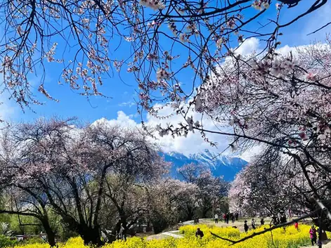 Gala Peach Blossom Village · 嘎拉桃花村
Gala Peach Blossom Village嘎拉桃花村
Gala village (嘎拉村) is a Gongbu Tibetan village in Linzhi town, Bayi District, in the Nyingchi municipality of Tibet, standing on the bank of the Niyang River beside National Highway 318 with more than 1,200 wild peach trees over more than 270 mu; Tibet Daily calls it the place styled Tibet's first peach-blossom village.
Read the place guide →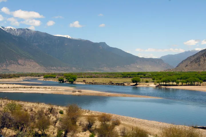 The Nyang River valley near its confluence with the Yarlung Tsangpo, Bayi District, Nyingchi · 林芝市巴宜区尼洋河风光,尼洋河与雅鲁藏布江交汇处附近 Source-recorded photograph date: Taken on 6 May 2011.
Niyang River Scenery尼洋河风光
The Niyang River (尼洋河, Tibetan 娘曲) runs through Bayi District in the Nyingchi municipality of Tibet, and the district culture and tourism bureau treats its scenic belt as one of the district's landscapes combining natural and human features; the Ministry of Ecology and Environment calls the river the mother river of the Gongbu region.
Read the place guide → AI illustration · AI 示意图(仅供参考,非该地点实拍)
Sejila Mountain Official Viewpoint色季拉山正规观景点
Sejila Mountain (色季拉山) is a mountain in Bayi District, Nyingchi, Tibet, placed by the regional culture and tourism department in the eastern section of the Himalaya, whose pass on the Sichuan–Tibet highway is a point from which Namcha Barwa can be seen at a distance.
Read the place guide → Mist rising over the forested valley of Lulang Forest Sea, Bayi District, Nyingchi · 林芝市巴宜区鲁朗林海云雾缭绕的森林山谷 Source-recorded photograph date: 22 May 2010 (original upload date).
Lulang Forest Sea鲁朗林海
The Lulang Forest Sea (鲁朗林海) is a forest landscape on Sejila Mountain in Lulang town, Bayi District, Nyingchi, Tibet, which the Bayi District government places in the core area of Sejila Mountain National Forest Park and gives an average elevation of 4,000 metres.
Read the place guide →Plan your visit
Getting there
Bayi District covers the centre of Nyingchi. Search for 巴宜区 in a map app to find stations and your accommodation.
Where to stay →Build your route
Gala Peach Blossom Village and Niyang River Scenery are both listed here. The linked place guides have entrance and visit details.
Continue with Nyingchi →More in Nyingchi
Sources & geographic information
Administrative names and parent areas: Official geographic directory · Reference date 2026-09-06.
Some facts checked against 巴宜区 — Wikipedia contributors, CC BY-SA 4.0.
Some facts checked against 林芝市 — Wikipedia contributors, CC BY-SA 4.0.
Some facts checked against Bayi District — Wikipedia contributors, CC BY-SA 4.0.
Photo: Gala Peach Blossom Village · Source photographer · License not provided. EXIF orientation normalized; resized without changing aspect ratio; converted to WebP. No subject edits.
Photo: Niyang River Scenery · 山海风 · CC BY-SA 3.0. Full frame retained; proportionally resized and converted to WebP. No retouching or changes to the photographed subject. Card displays may crop the view.

Photo: Lulang Forest Sea · 牛糞 · CC BY-SA 3.0. Full frame retained; proportionally resized and converted to WebP. No retouching or changes to the photographed subject. Card displays may crop the view.

Map data © OpenStreetMap contributors. Pins mark approximate centres, not entrances or boundaries.