

Entry & permits for Tibet (Xizang)
Foreign tourists need Tibet entry approval, commonly called a Tibet Travel Permit, and an organised visit arranged through a specialist travel agency in China. Confirm your approved route before booking transport. Requirements differ for Taiwan residents and for travellers using mainland or Hong Kong/Macao Chinese resident documents; check the document guide before you book.
Check the travel-document requirements →Policy scope verified: 2026-09-06. UK FCDO: China regional travel advice ↗ State Council Taiwan Affairs Office: Tibet entry approval ↗ Xizang Department of Culture and Tourism: Medog border permit notice ↗
Explore the region
What this place is
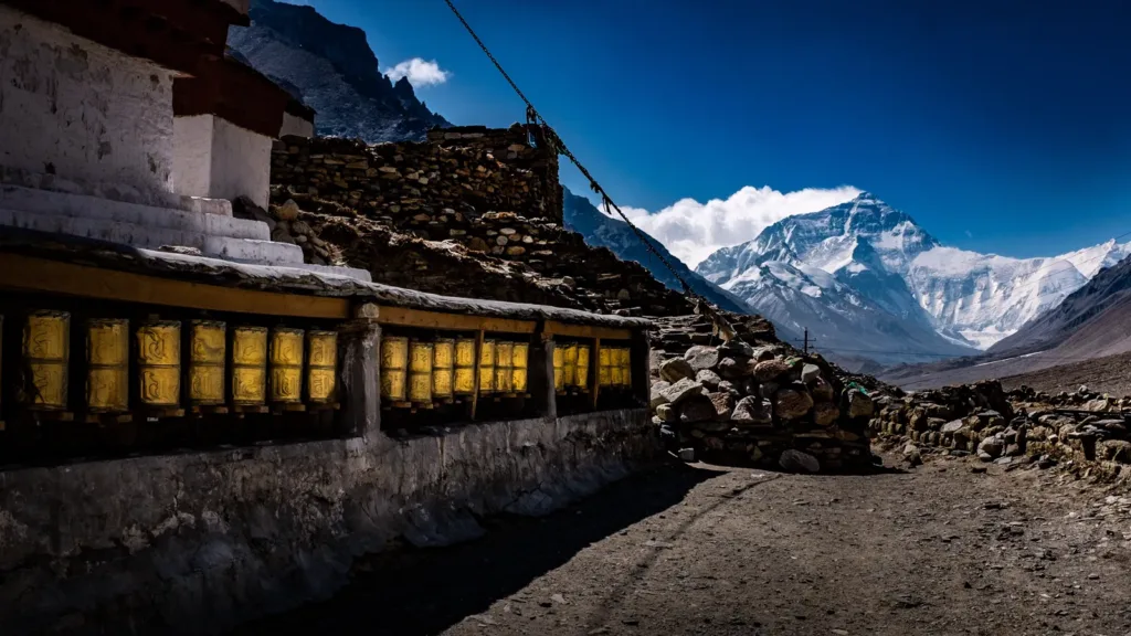
The name needs a little care. The public visitor endpoint is around Rongbuk Monastery (绒布寺), not the former climbers’ base camp farther inside the protected mountain area. The Qomolangma reserve is divided into core, buffer and experimental zones. A notice carried by the Xizang regional culture and tourism department says that visitors must stop at Rongbuk: Provincial Road S515 ends there, and the road and the land within 100 metres on either side are described as an experimental-zone viewing area from which Everest can be seen at a distance.
A Xinhua explanation makes the same distinction in practical terms. The visitor camp was moved back to the Rongbuk area, while the mountaineers’ camp in the protected core is not a place for ordinary visitors to reach on their own. The visitor area therefore offers the mountain view without turning a sightseeing trip into an approach to the climbers’ camp.
What to look for
Start with the changing relationship between the monastery, the road and the mountain. Rongbuk Monastery is the named end of S515 in the official description, so the approach itself is part of the experience: look for the monastery’s high, spare setting, then use the signed visitor viewpoints near the road to watch the summit when clouds allow. Do not walk past boundary signs toward the former base-camp site or treat a map pin as permission to enter a protected zone.
This is also a place to observe restraint in a fragile landscape. Keep to marked areas, carry waste out as directed and ask before taking photographs inside the Buddhist monastery. The UK government’s Tibet travel advice specifically says to ask before photographing in Buddhist monasteries.
The latest public reopening notice I could verify says ticket sales resumed at 09:00 on 26 September 2026 after snow and ice clearance, but it also warned that some mountain roads and the base-camp visitor area still had snow, ice and slippery surfaces. “Open” therefore does not mean that every viewpoint or approach is safe on a particular day.
Getting there, entering and returning
This is a remote road destination, not a railway station or a normal urban bus stop. From Shigatse, arrange a road transfer or an organised Tibet itinerary through Dingri County (定日县). The Xinhua explanation places the scenic-area entrance about 20 kilometres southwest of the Dingri county seat; from there, the visitor route continues toward Rongbuk Monastery. The verified place names for planning are 日喀则 Shigatse → 定日县 Dingri County → 珠峰景区入口 Qomolangma scenic-area entrance → 绒布寺 Rongbuk Monastery. The sources read here do not establish a public line number, a regular coach timetable, a last departure or a reliable walk-in taxi service.
Inside the scenic area, do not assume that your own car continues to the visitor endpoint. A notice reported by CCTV says that, from 23 August 2023, passengers in ordinary vehicles—including private new-energy vehicles—must transfer to the scenic-area sightseeing bus; only listed special vehicles and approved operational vehicles were exempt. Confirm the current transfer point, ticket or reservation process, road condition and the final return service before entering. The notice does not publish a timetable, so arrange the return with the same driver or tour operator rather than planning to find a bus after sunset.
Foreign visitors must solve the Tibet entry question before booking this route. The UK government states that travel to Tibet and the Tibet Autonomous Region requires a permit obtained through a specialist travel agent in China and an organised tour, and that authorities may stop issuing permits or restrict routes without notice. For an Everest-facing, border-region itinerary, ask the agency to confirm in writing whether any destination-specific foreign-traveller, border-area or other route permit is required in addition to the Tibet entry approval. A passport, an ordinary scenic-area reservation or an assumption that a permit for another Tibetan destination covers this route is not enough.
No reliable public source read for this article confirms a fixed daily opening schedule, a current ticket price, a same-day foreign-visitor procedure or a final-bus time for this exact visitor area. Check the latest notice and the operator’s instructions immediately before departure. The 26 September 2026 notice listed 0892-8263013, 19889228848 and 15962925678 for emergencies, but numbers and procedures should still be reconfirmed.
High-altitude planning
Treat the Rongbuk visitor area as a serious high-altitude visit, not a quick photo stop. The official explanation put the relocated visitor camp around 5,000 metres and the old climbers’ base camp around 5,200 metres; those figures are useful planning context, not a current survey of every viewpoint. Build in acclimatisation days at lower stops, move slowly and keep the itinerary flexible. Cold, wind, strong sun and rapidly changing mountain weather can make a short exposed visit tiring even when the road is open.
If headache, dizziness, unusual breathlessness, nausea or marked weakness begins, stop exertion and do not continue higher. CCTV’s health guidance advises telling companions, ending physical activity and avoiding further ascent; worsening symptoms or symptoms that do not improve require oxygen, medical help or descent to a lower altitude. Anyone with an unstable heart or lung condition, a respiratory infection or another relevant medical concern should seek individual medical advice before planning the route.
Find Mount Everest Base Camp Visitor Area
珠穆朗玛峰大本营开放游览区 · 定日县
The pin marks the area, not the entrance.
Sources & visit information
Sources checked on 2 November 2026. Hours, tickets, reservations and transport can change; confirm with the operator before you go.
Image credits & notes (1)
- Rongbuk Monastery in the Rongbuk area with Qomolangma (Mount Everest) behind it; the prayer-wheel foreground shows the monastery–mountain relationship described in the visitor-area article. Photo: Mondo79Photo: CC BY 2.0