

Entry & permits for Tibet (Xizang)
Foreign tourists need Tibet entry approval, commonly called a Tibet Travel Permit, and an organised visit arranged through a specialist travel agency in China. Confirm your approved route before booking transport. Requirements differ for Taiwan residents and for travellers using mainland or Hong Kong/Macao Chinese resident documents; check the document guide before you book.
Check the travel-document requirements →Policy scope verified: 2026-09-06. UK FCDO: China regional travel advice ↗ State Council Taiwan Affairs Office: Tibet entry approval ↗ Xizang Department of Culture and Tourism: Medog border permit notice ↗
Explore the region
Tap any red Chinese text to hear it in Mandarin.
Start with the right Tingri
The name “Tingri” is used in more than one way. This guide is for Gangga Town (岗嘎镇), often labelled Tingri or Old Tingri, rather than Shegar (协格尔), also called New Tingri. Gangga sits at about 4,348 metres, while the wider Tingri basin rises above 4,500 metres. Confirm the Chinese destination before you leave: a driver, hotel, or guide should see 岗嘎镇 / 老定日 and the exact local meeting point, not only the English word “Tingri”.
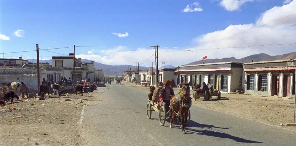
Gangga is worth treating as a highland settlement, not as a fabricated “Everest town”. Its setting is an open basin of grassland and snowmelt streams, with the Himalayan skyline appearing and disappearing as cloud and light change. The town historically served as a trading post where goods from Nepal met Tibetan wool, livestock and salt. Today, it works best as an orientation and service stop before a separately arranged journey towards the Everest region.
What to look for
From a permitted public viewpoint or the edges of the settlement, look across the broad basin rather than expecting a built attraction. Notice how grazing land, low buildings, road traffic and the Himalayan wall share the same open space. Visibility is weather-dependent, and a roadside mountain view is not a guaranteed Everest viewpoint.
The local religious thread is Tingri Lankor, associated with the Indian Buddhist teacher Padampa Sangye. The monastery is described as having been founded in 1097 within his meditation cave and as being under restoration. This is a place for quiet observation, not a promise of an interior tour. Ask your guide or local religious staff whether visitors may enter, where photography is acceptable, and whether a ceremony or retreat makes a visit inappropriate. Do not photograph people, monks or religious rooms without permission.
A useful way to visit is to spend a short period first observing the settlement and basin, then ask locally about Tingri Lankor only if access is available. Read any public inscriptions, watch how pilgrims or residents use the space without interrupting them, and keep the distinction between a living religious site and a sightseeing set. The old trading role and Padampa Sangye tradition are reasons to pay attention to the place; they do not establish opening hours, a ticket or guaranteed access.
Entry, permits and route limits
For foreign visitors, Tibet travel requires a permit arranged through a specialist travel agent in China and an organised tour. The UK government notes that permits can stop being issued or that travel can be restricted without notice, even after planning. Carry the passport and the documents supplied for the approved itinerary, and ask the operator to confirm that Gangga/Old Tingri is named in the route.
A Tibet Travel Permit should not be treated as proof that every onward road is open. Everest-area travel, border-facing roads, nature-protection areas and any continuation towards Nepal can have additional route, scenic-area or border controls. The exact current document list for a particular foreign traveller and itinerary must be confirmed by the authorised operator and the relevant local authorities before payment or departure. This guide does not claim that one generic permit covers those extensions.
Getting there and getting back
The practical approach is by an arranged road vehicle. A current English route guide describes the Lhasa-side overland approach through G318 and G349; a regional tourism report also identifies G318 and G219 as important tourism corridors in Shigatse. These are road corridors, not a direct railway or a guaranteed town-bus service.
When booking, write the destination in Chinese and separate the two likely stops: 岗嘎镇(老定日) for Gangga, and 协格尔镇 Xiégé’ěr Zhèn for Shegar/New Tingri. Give the driver the exact hotel, guesthouse or meeting point once confirmed. No current public bus timetable or confirmed passenger stop at Gangga was established in the sources used for this guide. Arrange the return vehicle and the next overnight stop before leaving the road network; do not assume that a passing car or a same-day ride back to Shigatse will be available. Recheck road controls, weather, daylight and the approved route on the day of travel.
High-altitude planning
At roughly 4,348 metres in Gangga and higher across the basin, this is not a place to use as a first-night arrival after a rapid ascent. The CDC advises gradual acclimatisation, avoiding “too high too fast”; once above 3,000 metres, its cited wilderness-medicine guidance recommends limiting sleeping-altitude gains to no more than 500 metres per night and adding acclimatisation nights as altitude rises. Headache, nausea, dizziness or unusual fatigue are reasons to stop ascending and tell the guide. Worsening symptoms require medical advice and descent, not a determined push towards a viewpoint.
Pack warm layers, sun protection, water and any personal medicines. Confirm in advance what vehicle support, oxygen and medical response are actually available; local service and supply conditions can change after weather, road or infrastructure disruption. Do not turn a high-altitude religious and landscape visit into an unsupervised trek across open land or towards a border.
Combine your visit
Suggested order for this visit:
-
Gangga town centre
Begin with the former trading settlement and arrange onward travel.
-
Tingri Lankor
Add the local religious site if access is available.
-
Permitted Tingri Plain viewpoint
Finish with the landscape that made the town a highland route stop.
This is an editorial sequence based on the features described in the sources. Confirm access locally; no walking time, shared admission or guaranteed interior access is implied.
Find Old Tingri
定日 · 定日县
The pin marks the area, not the entrance.
More places nearby
Approximate straight-line distances between map pins, not travel distances.
Rongbuk Monastery 绒布寺
48 km awayRongbuk occupies the upper Dzakar Chu valley on the northern side of Everest. Its compact monastic buildings and terraced chorten stand against a much larger mountain landscape, with the north face visible when the weather…
View guide →Mount Everest 珠穆朗玛峰
73 km awayEverest’s summit marks the China–Nepal border and reaches 8,848.86 metres according to the joint 2020 survey. For a sightseeing visit from Tibet, the northern Rongbuk valley provides the relevant orientation: the north face…
View guide →Pelkhu Tso 佩枯错
107 km awayPelkhu Tso, also written Peiku or Paiku, fills a high basin near the boundary of Gyirong and Nyalam. Its two broad lobes create a distinctive dumbbell outline, and ancient shorelines record earlier water levels. The lake is…
View guide →Sources & visit information
Sources checked on 2 November 2026. Hours, tickets, reservations and transport can change; confirm with the operator before you go.
Image credits & notes (1)
- A historic street in Tingri (Gangga / Old Tingri), photographed in October 2004, with low Tibetan buildings, livestock and the surrounding hills. Photo: ReurinkjanPhoto: CC BY 2.0