

Entry & permits for Tibet (Xizang)
Foreign tourists need Tibet entry approval, commonly called a Tibet Travel Permit, and an organised visit arranged through a specialist travel agency in China. Confirm your approved route before booking transport. Requirements differ for Taiwan residents and for travellers using mainland or Hong Kong/Macao Chinese resident documents; check the document guide before you book.
Check the travel-document requirements →Policy scope verified: 2026-09-06. UK FCDO: China regional travel advice ↗ State Council Taiwan Affairs Office: Tibet entry approval ↗ Xizang Department of Culture and Tourism: Medog border permit notice ↗
Explore the region
Tap any red Chinese text to hear it in Mandarin.
Why this place matters
Duoqing Lake sits in a landscape where the county boundary, wetland protection and the border-oriented Yadong travel corridor meet. The official land-registration notice places the national wetland park within Shigatse and says its area involves both Kangma County and Yadong County. That wider setting matters when planning: a map label, a wetland view and the permission to travel along the approved route are three different things.
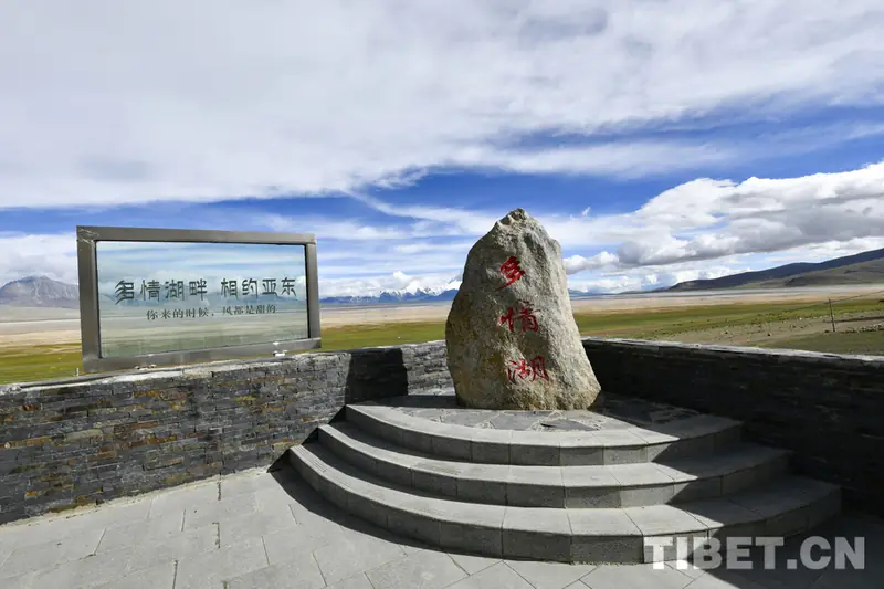
The view is unusually legible. From a permitted roadside or visitor viewpoint, the lake and marsh form a low foreground while Chomolhari stands beyond the open grassland. A Xinhua report identifies the mountain as being in Pali Town, Yadong County, and records visitors photographing it from the wetland park; it also gives the local name “Goddess Peak.” The 2026 regional report describes the wetland as wildlife habitat and places it within Yadong’s wider sequence of highland grassland, snow mountains and lower valleys.
This is also a protected landscape whose visitor arrangements are still being shaped. A national forestry report says that the 2026–2035 master-plan revision for Duoqing Co National Wetland Park began in March 2025. Do not treat an old travel post’s “free,” “24 hours” or “open access” wording as a current operating notice.
What to look for
Start with the relationship between water, marsh and the mountain rather than searching for one ornamental structure. On a clear, calm day, look across the wetland for the changing outline of Chomolhari and any reflection on open water. Weather, wind and cloud can alter the view quickly; there is no reliable fixed “best hour” in the sources read for this draft.
Use a guide to identify the edge of the wetland and the area where visitors may stop. Observe birds and grazing animals from firm ground, keep to any marked route and do not walk onto marsh, lake ice or unmarked meadow. The park is a habitat, not a place for feeding wildlife, collecting plants or making a private shortcut between photo stops. Keep voices low near birds and ask before photographing local residents.
The scenery is easy to misread as an invitation to wander. The wetland park’s current visitor infrastructure, exact entrance and any boardwalk or viewing platform were not independently confirmed. A 2026 official report says Yadong is using a “large opening, small closure” model with organised sightseeing and an “Yadong Culture and Tourism” WeChat mini-program for attraction information and reservations, but it does not confirm that every wetland viewpoint or every foreign visitor can use the same booking path.
Permits, entry and safety
Foreign passport holders must arrange permission to travel to Tibet through a specialist travel agent in China and travel on an organised tour, according to the current UK government China travel advice read for this draft. Authorities may stop issuing permits or restrict travel without notice. A normal attraction reservation or a domestic visitor’s identity-card booking is not a substitute for the approved Tibet itinerary.
The route also runs through the Yadong–Kangma border-direction area. Before booking, ask the authorised agency in writing whether the approved itinerary covers the exact Duoqing Lake stop, whether a border-area travel permit or other local permission is required for the relevant section, and how foreign passports will be checked at road controls. The sources read here do not provide a current, legible 2026 public permit list for this specific wetland; that is a route-specific item to confirm, not a reason to assume that an ordinary entry letter is enough.
This is a very high-altitude outing. A third-party travel page places the lake at roughly 4,460–4,485 metres, but that figure was not matched to a current official park notice, so use it as a planning warning rather than a definitive survey value. CDC guidance notes that travellers can develop altitude illness at much lower elevations, recommends gradual acclimatisation and says not to continue sleeping higher when symptoms are present; worsening symptoms despite rest or treatment require descent. Build in time at lower altitude first, avoid running and alcohol, protect yourself from cold, wind and strong ultraviolet light, and carry enough water, food and warm clothing. Anyone with relevant heart or lung conditions should obtain medical advice before a remote high-altitude trip.
Getting there and returning
The practical approach is by an arranged road vehicle, not by rail or a regular city bus. An official Tibet tourism itinerary places the Shigatse-sector route on Jiangzi–Kangma–Yadong (江孜—康马—亚东), with a separate day for touring Yadong. A current third-party guide places the wetland-viewing area in Duina Township, Yadong County (亚东县堆纳乡) beside G562, the Ri–Yadong road (G562 日亚公路), and describes the approach from the Shigatse direction as G219 towards Kangma/Yadong and then G562. Because the latter is not an official entrance notice, have the driver or agency confirm the exact road pull-off and visitor point on the day.
In Amap/Gaode Maps, search 多庆错与卓木拉日观景区 Duōqìngcuò yǔ Zhuómùlārì Guānjǐngqū, then try 多庆错国家湿地公园 Duōqìngcuò Guójiā Shīdì Gōngyuán, 多庆错 Duōqìngcuò, or 亚东县堆纳乡 Yàdōng Xiàn Duīnà Xiāng if the first result is missing. Keep the Chinese name and the approved itinerary with the driver. No reliable direct rail station, bus stop, fixed taxi fare, or current journey time to the wetland was found, so none is invented here. The regional railway station in Shigatse is an arrival point for the city, not a station at the lake.
Before leaving the vehicle, agree on the exact pick-up point, return time and fallback destination with the guide. Return with the same approved vehicle towards Yadong, Kangma or the next overnight stop on the itinerary; do not assume that a passing bus or an unmarked roadside pin will provide a return connection. Road, weather, checkpoints and wetland operations can change, and the 2026–2035 park plan is still being revised.
Current entrance arrangements, ticketing, opening hours, reservation availability, the exact foreign-visitor permit coverage and the road-side stopping point should all be confirmed immediately before departure.
Find Duoqing Lake and Chomolhari Viewing Area
多庆错与卓木拉日观景区 · 亚东县
The pin marks the area, not the entrance.
Sources & visit information
Sources checked on 2 November 2026. Hours, tickets, reservations and transport can change; confirm with the operator before you go.
Image credits & notes (1)
- Duoqing Lake and Chomolhari Viewing Area · 多庆错与卓木拉日观景区Photo: media.tibet.cnResized for the web; the photo itself has not been edited.