

Photo adjustments
Full frame retained; proportionally resized and converted to WebP. No retouching or changes to the photographed subject. Card displays may crop the view.
Explore the region
About Khunjerab Pass
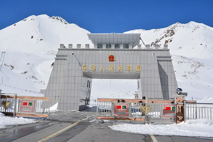
The snow-and-rock landscape and border gate are its principal visual features, but sightseeing at the Chinese gate and crossing the international border are separate journeys. The port also serves working passenger and freight traffic. Treat it as a specifically arranged high-altitude border visit, not an automatic extension of every Tashkurgan itinerary.
China and Pakistan agreed in principle to open the pass in September 1981, followed by a formal protocol in August 1982. The road across the pass was completed in 1982. The crossing opened to citizens of both countries in May 1983 and to people from third countries on May 1, 1986. The border gate itself stands at 4,733 metres. In 1993, inspection offices moved from Pilali (皮拉力) to Tashkurgan county town (塔什库尔干县城) because of the altitude and severe climate. The Wakhi name combines words for a house and a spring-fed creek or waterfall.
What to look for
- The high pass frames the international gate in a stark mountain landscape.
- The highway crossing links China’s Pamir route with northern Pakistan.
Background & history
Khunjerab Pass (Chinese: 红其拉甫口岸; Urdu: درہ خنجراب ; Uyghur: قونجىراپ ئېغىزى) is a mountain pass on the Karakoram Highway in Pakistani-administered Gilgit-Baltistan bordering Xinjiang Autonomous Region of China. It is a high-altitude mountain pass lying at an elevation of 4,693 metres (15,397 ft) above sea level in the Karakoram. It holds a significant strategic position on the northern border of Pakistan, specifically in the Gilgit-Baltistan's Hunza and Nagar districts. Additionally, it is positioned on the southwestern border of China with Pakistan, in the Xinjiang region. Near Khunjerab Pass, there is another pass known as Mutsjliga Pass, which stands at an elevation of 5,314 metres (17,434 ft) and is located at approximately 36.97374°N 75.2973°E / 36.97374; 75.2973.
Excerpt from Wikipedia: Khunjerab Pass · Wikipedia contributors · CC BY-SA 4.0. Selected introductory sentences; formatting simplified. Background information, not current visitor-service advice.
The surrounding area
A southwestern urban and cultural chapter with craft streets, food and residential life.
Location & getting there
Getting to Khunjerab Pass
Confirm your eligibility, documents, transport and permitted destination with the port or immigration service before leaving Tashkurgan. An international crossing requires arrangements for both countries; a domestic sightseeing booking does not grant border-crossing permission.
Combine your visit
Choose from these complementary stops when planning your visit.
-
Tashkurgan preparation塔什库尔干出发准备
Confirm the complete route and current access.
-
Authorised border-gate visit获准国门参观
Follow the assigned vehicle and visitor areas.
-
Return or confirmed crossing返程或已确认的跨境行程
Use the journey type and transport actually approved for your booking.
This is a suggested combination, not a timed route; confirm the opening and transport arrangements for your date.
Find Khunjerab Pass
红其拉甫口岸 · 喀什地区
The pin marks the area, not the entrance.
More places nearby
Approximate straight-line distances between map pins, not travel distances.
Tashkurgan塔什库尔干
104 km awayTashkurgan is a highland town in the eastern Pamir region, with a ruined stone fortress above the surrounding settlement. Its historical position connected routes toward Kashgar, the southern Tarim Basin and lands farther west…
View guide →Muztagh Ata慕士塔格峰
161 km awayMuztagh Ata is a heavily glaciated mountain in the eastern Pamir region. Its broad snow-covered profile is a defining view from the Karakul and Karakoram Highway area. The mountain’s presence can be appreciated from authorised…
View guide →Karakul (China)喀拉库勒湖
180 km awayKarakul in Akto County is a high-altitude lake beside the Karakoram Highway, with Muztagh Ata and the Kongur mountain group forming its wider setting. Still conditions can create striking reflections, while wind changes the…
View guide →Sources & visit information
The sources below support the place-specific description and arrival information. Suggested combinations are editorial planning ideas; confirm current opening, entry arrangements and transport services for your date.
- Xinjiang Government: 2026 border sightseeing, international passenger processing and immigration service centres ↗
- Khunjerab Pass — Wikipedia geographic and historical reference ↗
- Chinese Wikipedia: 红其拉甫口岸 (revision 94266001, 2026-09-09) ↗
- English Wikipedia: Khunjerab Pass (revision 1364728190, 2026-07-18) ↗
Geographic and historical facts selectively adapted from Wikipedia contributors, Khunjerab Pass · CC BY-SA 4.0. Source revision 1364728190.
Background paragraphs translated and condensed from Wikipedia contributors, "红其拉甫口岸", Chinese Wikipedia · CC BY-SA 4.0. Source revision 94266001.
Background paragraphs condensed from Wikipedia contributors, "Khunjerab Pass", English Wikipedia · CC BY-SA 4.0. Source revision 1364728190.