

Explore the region
Tap any red Chinese text to hear it in Mandarin.
Why come
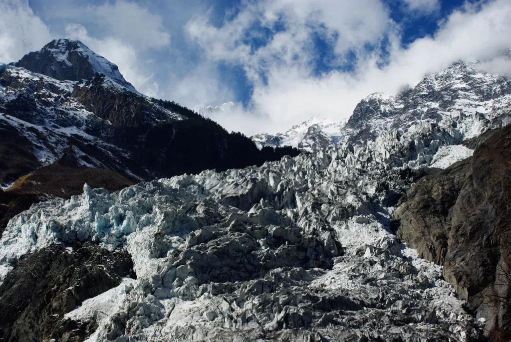
Mingyong Glacier is tied directly to Kawagarbo, the main peak of the Meili Snow Mountains. Its lower ice reaches a forested mountain zone at a relatively low altitude, so the view is read in layers: summit, ice, forest and the Lancang valley rather than a distant snowfield. That meeting of glacier and forest is the reason to come here, even when cloud hides the higher peak.
This is a place for a managed mountain walk and close viewing, not an invitation to climb the ice. The scenic-area route brings the glacier into view alongside the mountain’s Tibetan religious landscape, with Taizi Temple, upper viewing points and Lotus Temple appearing as route landmarks in visitor descriptions.
What to look for
Begin by watching how the valley changes as the route leaves the village-side approach and rises into forest. The glacier is easier to understand as a long ice tongue in a mountain valley than as a single white object. At the higher viewpoints, look back toward Kawagarbo and compare the ice against the dark forest and steep valley walls. Weather can erase the summit while leaving the lower glacier and forest visible, so do not treat a cloudy visit as a failed one.
The visitor route has distinct parts. Current listings describe an approach from the visitor centre by sightseeing vehicle to a trail start, followed by an uphill walk toward Taizi Temple, viewing platforms and Lotus Temple. Treat the vehicle section and the trail as separate services: a ticket for one does not automatically prove that the other is running that day.
Stay on the signed, managed route and use the viewpoints rather than trying to reach the ice. A 2026 notice for Meili Snow Mountain National Park prohibits tourism and adventure activities in undeveloped or unopened areas, including areas with serious ecological, geological or rescue risks. The notice is broader than this one route, but its boundary is directly relevant to a glacier visit: follow staff instructions and never turn a scenic walk into an unapproved approach.
How the visit works
Plan a substantial half day. Trip.com currently presents a recommended visit of four to six hours and lists an 08:00–16:30 admission window, with entry stopping at 16:30. These are platform details, not a guarantee of the next operating day. Official notices show that the operator has suspended or restored Mingyong Glacier visits in response to weather and route conditions, including a 2025 restoration notice and an earlier closure-and-reopening notice after heavy snow. Check the latest announcement before leaving.
Admission, sightseeing-vehicle use and any optional horse service should be treated as separate items. The reviewed sources do not establish a current official price sheet, a guaranteed bundle or a current rule for foreign-passport booking. Confirm the day’s ticket, shuttle, payment method, identification requirements and last return vehicle with the operator or the entrance staff. A listing and a 2024 operator-announcement reproduction publish the enquiry number 0887-8414949, but confirm that it is still answering before relying on it.
The uphill section is a high-altitude walk even when the path is managed. A 2026 visitor account describes roughly 8–9 km round trip and a sequence through Taizi Temple, viewing platforms and Lotus Temple; use that as a planning impression, not as a fixed distance or timetable. Carry water and food, wear shoes with grip, and leave enough daylight for the descent and the return road connection.
Access and return
The practical approach is by road. From Shangri-La, reach Deqin County by long-distance coach or private car, then continue to Mingyong Village. From Feilaisi, arrange a road transfer to the same destination rather than assuming that a sightseeing route or a local shuttle continues to the entrance. The reviewed English tourism guide confirms the Deqin/Feilaisi road approach but does not provide a current official timetable.
Some travel guides report buses from Deqin Bus Station to Mingyong Village, while also warning that services may stop. Because those schedules are not confirmed by a current operator page, check the departure at Deqin Bus Station on the day of travel and arrange the return before entering the scenic area. Do not build a same-day plan around a historical departure time.
For a taxi or hired car, show the Chinese destination 明永冰川开放游览区 Míngyǒng Bīngchuān Kāifàng Yóulǎnqū and the public listing address 云南省迪庆藏族自治州德钦县明永村 Yúnnán Shěng Díqìng Zàngzú Zìzhìzhōu Déqīn Xiàn Míngyǒng Cūn. The listing identifies the village but does not establish a precise passenger drop-off point at the current gate, so ask the driver and entrance staff to confirm the visitor-centre approach rather than following a map pin for the wider Meili Snow Mountain area.
There is no applicable metro, water route or railway arrival at the visitor area in the reviewed sources. The useful intercity alternative is coach travel to Deqin followed by a confirmed road connection; return arrangements matter more than a nominal route on a map.
Before you go
Recheck weather, trail access and the last road connection on the day. Mingyong’s operating history includes weather-related closure and reopening notices, and an open listing cannot override an entrance decision made for snow, rain, rockfall or trail safety.
The broader Meili Snow Mountain notices distinguish open visitor routes from undeveloped or unopened lines. Do not follow unofficial “shortcuts,” approach glacier ice, or join an unmanaged trek beyond the signed route. International visitors should also confirm whether the current ticket and identity-check process accepts a passport; domestic-ID procedures should not be assumed to apply.
Find Mingyong Glacier Visitor Area
明永冰川开放游览区 · 德钦县
The pin marks the area, not the entrance.
Sources & visit information
Sources checked on 1 November 2026. Hours, tickets, reservations and transport can change; confirm with the operator before you go.
Image credits & notes (1)
- Mingyong Glacier descending between snow-covered peaks and dark forested slopes, photographed in February 2009. Photo: J.L. Cogburn (Flickr username cogburnphoto; Commons credits as Cogburn CC)Photo: CC BY-SA 2.0