


Get to know Deqin County
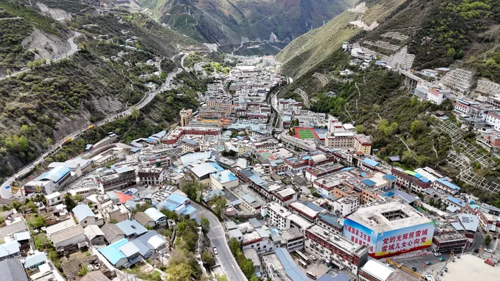
Photo adjustments
Full frame retained; proportionally resized and converted to WebP. No retouching or changes to the photographed subject. Card displays may crop the view.
- Administrative area
- County · 县
- Part of
- Diqing Tibetan Autonomous Prefecture
- Chinese name
- 德钦县
- Local areas
- County guide
Area & population
- Area in the source
- 7,596.00 km²
- Population · 2020 census
- 54,736
Source: cited geographic source, as of the dates shown.
Setting and landscape
The county is shaped like a long blade, about 188 kilometres north to south and 68 kilometres wide, with the Yunling range (云岭) on the east and the Nu River range (怒江山脉) on the west. The Mekong, here called the Lancang (澜沧江), and the Jinsha (金沙江) run through deep gorges; in places the valley floor lies 2,000 to 2,500 metres below the plateau surface. The Meili Snow Mountains (梅里雪山), Jiawu (甲吾雪山), Runzi (闰子雪山) and Baima Snow Mountains (白马雪山) all rise above 5,000 metres. The county town, Shengping (升平镇), stands at 3,400 metres.
Kawagebo (卡瓦格博), the main peak of the Meili range at 6,740 metres, is Yunnan's highest mountain, and the county government lists it among the snow peaks that no one has yet climbed. With twelve surrounding snow peaks that average above 4,800 metres, it forms the "Thirteen Peaks of the Prince" (太子十三峰). Baima Snow Mountain National Nature Reserve covers 281,600 hectares and is a key habitat of the Yunnan snub-nosed monkey.
History
The name comes from a lamasery called Deqinling; in Tibetan "Deqin" means "great peace and happiness". In 1726 the Qing fixed the Sichuan-Yunnan boundary and placed the area, then called Adunzi (阿墩子), under Yunnan. The Republican authorities set up an Adunzi administrative bureau in 1932 and renamed it Deqin in 1935. In September 2024 Yezhi (叶枝镇) and Badi (巴迪乡) were moved into Deqin from Weixi Lisu Autonomous County (维西傈僳族自治县), and because of geological hazards a new county seat began construction at Yezhi on 26 April 2025.
What to see
The Mingyong Glacier (明永冰川) and Sinong Glacier (斯农冰川) are low-altitude, low-latitude glaciers visible from the east bank of the Lancang. The county government also points to Yubeng village (雨崩村), known as a secluded, otherworldly retreat. Between Benzilan (奔子栏) and the top of Baima Snow Mountain, the county government says, the landscape passes through different climate zones and shows the landforms of a tectonic plate suture.
The county has 16 Tibetan Buddhist monasteries, including Hongpo (红坡寺), Deqin (德钦寺) and Dongzhulin (东竹林寺). Nationally protected sites are Cizhong Church (茨中教堂), the Adunzi and Meili sections of the Tea Horse Road (茶马古道), the Yezhi chieftain's office (叶枝土司衙署) and the Tongle Lisu village houses (同乐傈僳族民居建筑群). Feilai Temple (飞来寺) is a provincial protected site. The Liutong River iron-chain bridge (溜筒江铁索桥) survives from the Yunnan-Tibet tea route, and Xidang (西当) and Niuba (纽巴) have hot springs.
Highlights
- Kawagebo 卡瓦格博: Main peak of the Meili range, 6,740 m, Yunnan's highest.
- Mingyong Glacier 明永冰川: Low-altitude glacier visible from the east bank of the Lancang.
- Yubeng village 雨崩村: Village known as a secluded retreat, in the county government's list of sights.
- Cizhong Church 茨中教堂: Nationally protected heritage site.
- Feilai Temple 飞来寺: Yunnan provincial protected site.
- Dongzhulin Monastery 东竹林寺: Tibetan Buddhist monastery known for murals; provincial protected site.
Sources for this guide
旅游资源 · Deqin County People's Government
区位及面积 · Deqin County People's Government
德钦县 - 维基百科,自由的百科全书 · Wikipedia (Chinese) · CC BY-SA 4.0
Original English written from the listed sources and checked sentence by sentence against quoted extracts by a separate reviewer. Updated 2026-09-25.
Explore Deqin County
Core places to explore, with English and Chinese names.
Places to explore around Deqin County
 Mingyong Glacier Visitor Area · 明永冰川开放游览区
Mingyong Glacier Visitor Area明永冰川开放游览区
Mingyong Glacier Visitor Area is the viewing area for Mingyong Glacier, a low-latitude glacier on the eastern slope of the Meili Snow Mountain range in Deqin County, Yunnan, developing directly from the range's main peak, Kawagarbo.
Read the place guide → Feilai Temple Meili Snow Mountain Viewpoint · 梅里雪山飞来寺观景区
Feilai Temple Meili Snow Mountain Viewpoint梅里雪山飞来寺观景区
Feilai Temple Meili Snow Mountain Viewpoint is the viewpoint at Feilaisi (Feilai Temple) in Deqin County, Yunnan, one of Deqin's seven recognised vantage points for viewing the Meili Snow Mountain range and its 6,740 m main peak, Kawagarbo.
Read the place guide → AI illustration · AI 示意图(仅供参考,非该地点实拍)
Yubeng Official Hiking Trails雨崩正规徒步线路
Yubeng Official Hiking Trails names the marked hiking routes into Yubeng, a village divided into upper and lower settlements deep in the Meili Snow Mountain range in Deqin County, Yunnan, normally reached on foot or by horse or mule.
Read the place guide → Wunongding Viewing Platform · 雾浓顶观景台
Wunongding Viewing Platform雾浓顶观景台
Wunongding Viewing Platform is a viewpoint at Wunongding, Deqin County, Yunnan, one of the county's seven recognised vantage points for viewing the Meili Snow Mountain range, sited on the axis facing the range's main peak, Kawagarbo.
Read the place guide →Plan your visit
Getting there
Deqin County is about 80 km in a straight line from central Diqing Tibetan Autonomous Prefecture. Search for 德钦县 in a map app to find stations and your accommodation.
Where to stay →Build your route
Mingyong Glacier Visitor Area and Feilai Temple Meili Snow Mountain Viewpoint are both listed here. The linked place guides have entrance and visit details.
Continue with Diqing Tibetan Autonomous Prefecture →More in Diqing Tibetan Autonomous Prefecture
Sources & geographic information
Administrative names and parent areas: Official geographic directory · Reference date 2026-09-06.
Some facts checked against 德钦县 — Wikipedia contributors, CC BY-SA 4.0.
Photo: Mingyong Glacier Visitor Area · Source photographer · License not provided. EXIF orientation normalized; resized without changing aspect ratio; converted to WebP. No subject edits.
Photo: Feilai Temple Meili Snow Mountain Viewpoint · Source photographer · License not provided. EXIF orientation normalized; resized without changing aspect ratio; converted to WebP. No subject edits.
Photo: Wunongding Viewing Platform · Source photographer · License not provided. EXIF orientation normalized; resized without changing aspect ratio; converted to WebP. No subject edits.
Map data © OpenStreetMap contributors. Pins mark approximate centres, not entrances or boundaries.