

Explore the region
Tap any red Chinese text to hear it in Mandarin.
Why this place is distinct
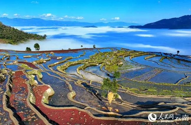
Samaba is a working mountain landscape, not a single isolated lookout. The Honghe County government describes more than 16,000 mu of terraces, over 4,300 levels, six main irrigation channels, more than 4,000 mu of surrounding forest and 21 villages. The fields occupy different elevations, so the view changes as water, crops and light move across the slopes.
The named focal point is the Lukuibadi (鲁亏巴底) viewing platform. From here, look for the relationship between four parts of the Hani agricultural system: forest above the villages, villages among the slopes, water-fed terraces below them and the channels that connect the levels. That sequence is more informative than photographing only the most reflective patch of water.
The county’s historical account links the long cultivation of Samaba to the Ming Hongwu period, when the local tusi official Wu Bangpo is said to have led residents in cutting channels and making paddies. Read this as the local historical framing of a continuously worked landscape, not as a claim that every visible terrace was created in one period.
How to observe the terraces
At Lukuibadi, first take in the full slope and then pick out the irrigation lines, village clusters and changes in field size. If the paddies are being prepared or filled, watch how water makes the stepped geometry legible; in a growing or harvest period, compare the colour and texture of fields at different elevations. Ask locally which paths and viewpoints are open on the day, and remain on designated access routes. These are working fields and village surroundings: do not walk into paddies, enter homes or photograph residents or farm work without permission.
Weather and the agricultural cycle can change the view substantially. The sources read for this article do not establish a single best month or a guaranteed daily activity schedule, so plan for the landscape rather than a promised performance. The official scenic-area description identifies the site as a national 4A tourist attraction, but current visitor services still need checking before departure.
Practical visit and access
The operator’s FAQ says the scenic area usually opens 08:00–18:00, and that an admission ticket is required; it also says prices can vary by season and activity. Treat those as operating guidance rather than a guaranteed current timetable or price. Confirm the opening day, ticket channel, payment method and any passport or foreign-visitor procedure with the operator before travelling.
For public transport, the operator’s published timetable lists coaches from Honghe County (红河县) to Baohua Town (宝华镇) at 07:30, 10:00, 13:10 and 15:30. The listed return departures from Baohua Town to Honghe are 08:00, 09:30 and 12:30. The page does not give a posting date, and it describes a town-to-town service rather than a confirmed shuttle to the scenic-area gate. Verify the departure point and same-day service before setting out.
A 2020 county government event notice names the departure point as 凹腰山新客运站 (Aoyao Mountain New Passenger Station) and gives an older, different set of Baohua departures. Because that notice is event-specific and dated 2020, use the current operator timetable above as the working lead but confirm which county terminal is operating now.
For a self-drive approach, that same county notice describes following the transit road after entering Honghe County to the Manban River–Baohua fork (曼板河至宝华岔路), then continuing to the scenic-area gate. No source read for this article confirms a current public bus from Baohua Town to the gate, a precise drop-off point or a walking time. Arrange the final road transfer with the operator or a local driver rather than assuming the county coach reaches Lukuibadi. For the return, leave enough time to reach Baohua Town before the listed return departures; do not plan to rely on an after-closing shuttle that has not been published.
Before you go
The county government places the scenic area in Baohua Town, Honghe County, Honghe Hani and Yi Autonomous Prefecture, Yunnan. Different pages give different road distances from the county seat, so this article does not repeat a distance as if it were stable. Search for 撒玛坝万亩梯田景区 Sāmǎbà Wànmǔ Tītián Jǐngqū in Amap (高德地图) or another current map, then confirm the gate and the day’s operating notice with the operator.
Bring sun and rain protection and shoes suitable for uneven, damp mountain paths. Keep the terraces, channels and villages as a lived agricultural landscape in your frame, and leave farming access and residents’ privacy undisturbed.
Find Samaba Rice Terraces
撒玛坝梯田 · 红河县
The pin marks the area, not the entrance.
Sources & visit information
Sources checked on 2 November 2026. Hours, tickets, reservations and transport can change; confirm with the operator before you go.
Image credits & notes (1)
- Samaba Rice Terraces · 撒玛坝梯田Photo: yn.people.com.cnResized for the web; the photo itself has not been edited.