

Explore the region
Tap any red Chinese text to hear it in Mandarin.
A working landscape, not a single park
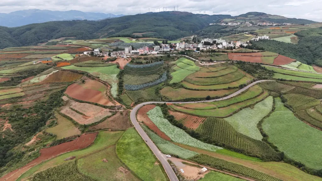
The Red Land area lies in Xintian Township in the northeastern part of Kunming’s Dongchuan District. Huashitou (花石头) is the useful road base and village reference; Dongchuan’s urban centre is a different destination. Around the village, cultivated slopes spread across a broad rural area rather than stopping at one entrance.
The colour has two layers. Iron-rich soil develops its red tones through oxidation, while farmers’ planting and harvesting create the shifting patchwork: exposed red earth beside green potato shoots, golden grain, white buckwheat flowers or darker green fields. Rain and low-angle light can change how strongly the colours read. This is a farmed landscape, not a decorative field made for visitors.
Viewpoints and timing
- Luoxiagou (落霞沟) looks into a folded valley of fields and villages. Its name means “Sunset Valley”, and late-afternoon light is the reason it is commonly used for sunset viewing.
- Jinxiu Garden (锦绣园) gives a more layered, close-patterned view of cultivated hills. It works well as a comparison with the wider valley at Luoxiagou.
- Damakan (打马坎) is the usual sunrise-facing stop, while Qicaipo (七彩坡) is known for parallel bands of different crops and soil colours. Reaching these stops requires road transfers; the names do not imply a continuous walking trail.
There is no single guaranteed “best” month because the fields are worked and the crop calendar changes. May–June often brings strong red-and-green contrasts with flowers and young crops; September–December can add harvested gold and late-season planting. February–March may bring yellow rapeseed in parts of the hills, while July–August can look predominantly green. Treat these as planning windows, not promises of a particular colour on a particular day.
Stay on public roads, marked viewpoints and established paths. Do not walk into planted fields or photograph residents as if they were part of a display. After rain, red clay can be slippery, and early-morning viewpoints are cold at elevation; allow time for weather and the return journey.
Getting there and moving around
By coach: The practical public-transport chain is Kunming North Bus Station → Dongchuan District Bus Station → a local service or arranged car toward Huagou and Huashitou. A transport guide updated in March 2026 lists only limited onward departures and advises checking with the station or local hosts; schedules, fares and the return service can change. Confirm the onward connection and the way back to Dongchuan before leaving the town.
By hired car: A direct road journey from Kunming is commonly described as roughly three to three and a half hours, but weather, traffic and the chosen road matter. Tell the driver 花石头(Huashitou) or 东川红土地 Dōngchuān Hóngtǔdì, not only “Dongchuan”, and arrange a vehicle for the viewpoint circuit. The G248 section through Huashitou was resurfaced in 2025, yet the branches to viewpoints remain narrow rural roads.
There is no metro or railway entrance at the Red Land viewpoints. The landscape is described as open public countryside with no general admission fee, but a broad open area is not the same as a promise that every viewpoint, shuttle or facility is free. Check local signs and current arrangements on the day. There is no single gate or universal opening timetable.
An overnight near Huashitou makes a sunset at Luoxiagou and a dawn start at Damakan more realistic than a rushed day return from Kunming. Whether travelling independently or with a driver, keep the Chinese place name, confirm the visitor drop-off, and secure the return connection before setting out.
Combine your visit
Suggested order for the visit:
-
Huashitou area
Get oriented among the cultivated hills.
-
Jinxiu Garden viewpoint
Look at the layered fields and villages.
-
Luoxiagou viewpoint
Compare the pattern under different light.
This is an editorial sequence of named spaces or places. It does not imply a verified walking connection or promise opening, ticket availability or a journey time.
Find Dongchuan Red Land
东川红土地 · 昆明
The pin marks the area, not the entrance.
More places nearby
Approximate straight-line distances between map pins, not travel distances.
Dahai Grass Mountain 大海草山
18 km awayDahai Grass Mountain spreads across high slopes in the Wumeng range near Huize. Rounded meadow hills, grazing animals and small streams give it a pastoral character, while the distant Guniuzhai peak marks the higher mountain…
View guide →Yuantong Temple 圆通寺
124 km awayYuantong Temple in central Kunming is arranged around a pond and Yuantong Hall. A stone bridge carrying an octagonal pavilion connects the entrance side with the hall, making water an unusually strong organising feature in the…
View guide →Green Lake 翠湖
125 km awayGreen Lake is a city park of water, causeways and pavilions in central Kunming. The north–south Ruan Causeway and east–west Tang Causeway help divide the water into smaller scenes, bringing changing views of willow-lined banks…
View guide →Sources & visit information
Sources checked on 23 October 2026. Hours, tickets, reservations and transport can change; confirm with the operator before you go.
Image credits & notes (1)
- Aerial view of cultivated fields, a village and rural road in Dongchuan Red Land, showing the working agricultural landscape. Photo: 瑞丽江的河水Photo: CC BY-SA 4.0