

Explore the region
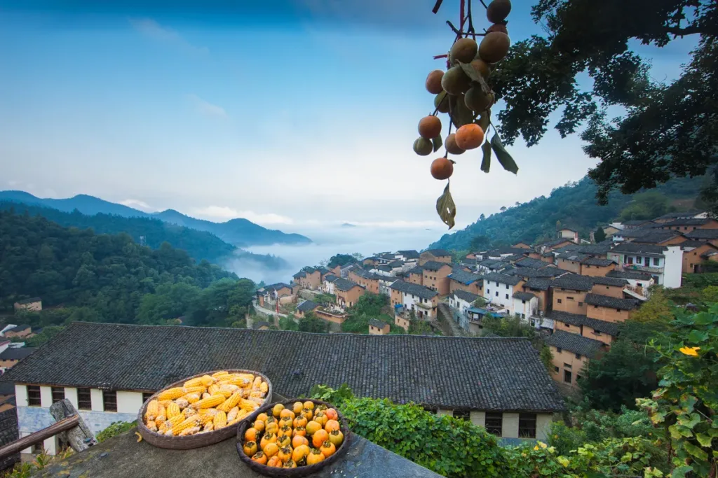
Yangchan Tulou (阳产土楼) is a hillside hamlet of rammed-earth houses in Shendu Town (深渡镇), She County (歙县), in the mountains of eastern Huangshan. It is a natural village inside Yueyuan Village (约源村), roughly 6–8 km from Shendu town, about 32 km from the county town of Shexian and about 40 km from Shexian North high-speed railway station. Some 360 earthen houses stand in rows up the slope — published counts run from about 300 to 372, depending on what is included — which makes this the largest surviving cluster of earthen buildings in southern Anhui. What separates it from the whitewashed Huizhou villages nearby is the material: red earth rammed into walls, grey tiles on top, bluestone under the footings.
What it is
The village sits in a hollow, so the houses stack rather than spread: mostly three-storey earthen blocks with small windows and thick walls, reached by stone steps and narrow lanes. Four springs are channelled through the village in open gutters, which supplied drinking water and still carry storm water away. The name describes the site: 阳 for the sun-facing slope, 产 for “steep” in the local dialect.
The building method is the reason to come. Local red soil was rammed into formwork on bluestone footings, with timber for beams and roofs; one account of the village adds bamboo fibre and glutinous-rice slurry to the earth mix. The walls carry the load, so the ground floor was given to livestock and storage, the middle floor to living rooms and the top floor to sleeping and grain. Small windows and thick walls were not only for warmth — the lanes were laid out to be defensible.
Published figures for the village’s elevation disagree: about 400 m in one account, nearly 800 m in another. The climb is real either way, and Longwangjian (龙王尖), the summit above the village, is put at about 900 m.
What to look at
Arrive at the car park at the top of the road and the whole village reads as one picture: a fan of earthen walls and grey roofs filling the hollow, with a viewpoint right beside the car park. From there, follow the stone steps clockwise into the village, as one published route description suggests, and look back every so often — the roofscape changes with each turn and the lanes mostly dead-end.
The individual things worth finding: the largest house, known as Tulou Wang (土楼王, “King of the Earthen Houses”) and marked by a plaque; the very narrow lane called Muzhi Street (拇指街, “Thumb Street”); and the village photography terrace, which gives the classic layered view. The village’s own list of sights also names the old primary school (阳产小学), the old well and a farm-tool culture museum (阳产农具文化展馆).
Above the village, the ridge of Longwangjian carries trench traces from a small blocking action in the Chinese Civil War, when retreating Kuomintang troops were engaged here. Walkers reach it, and the surrounding paths — the Yangchan old road (阳产古道) and the Wenchang Old Road (文昌古道) — on foot from the village.
The oldest surviving houses are said to be more than 200 years old; some are propped up or shut, and one building described as 300-odd years old is no longer open. Conservation is visible but incomplete, which is part of the place’s character.
Harvest drying (晒秋)
From September the village works as a drying floor. Maize, chillies, red beans, mung beans and pumpkins are spread on bamboo trays and set out on window sills, under the eaves, on roofs and on terraces, and left there through the sunny days around the autumn equinox. In 2025 the crop being talked about was a local June soybean, dried for oil that sells for more than a hundred yuan a jin and kept back as seed for the following year.
This is storage practice rather than a performance. The mountains are damp, and drying is how the harvest keeps through winter. The fullest trays and the warmest light come in October and November; March and April bring rapeseed on the terraces instead, and early morning after rain is when the valley below fills with cloud.
History
The village’s own story is a migration. Zheng clan members reached She County and settled at Dingtan (定潭) near Shendu, then moved up into these mountains at the end of the Ming or the beginning of the Qing, some 300 to 400 years ago; the whole village is surnamed Zheng. Accounts differ on where they came from — one line has them fleeing war from Zhengzhou in Henan, while state media and the village’s local history trace the route through Dingtan. The clan legend, as told in the village, has an ancestor’s hunting dog lying down in the hollow and refusing to leave, which decided the site.
Yangchan was an administrative village in its own right until 2008, when it was merged into Yueyuan Village. Photographers “found” the place in 2012 and it was listed among Huangshan’s top 100 photography spots; in August 2013 it entered the second batch of China’s Traditional Villages list, and in April 2015 the She County government signed a tourism development agreement for Yueyuan Village with a Huangshan cultural-industry investment company. Tourism is now run by Huangshan Shezhou Yangchan Tulou Cultural Tourism Development Co., Ltd (黄山市歙州阳产土楼文化旅游发展有限公司), which built the visitor service centre at the foot of the hill and operates the shuttle.
The numbers show what that has done: about 120,000 visitors and ¥4 million in revenue in 2021; 215,600 visits and ¥6.54 million in tourism revenue in 2024, with per-capita villager income above ¥26,000. As of March 2025 the village had 13 homestays, 12 farm restaurants, three cafés, two wine workshops and one milk-tea shop, with 210 guest beds. The 2025 National Day holiday alone brought 24,000 visits. Around 100 older residents still live here year-round.
Tickets, shuttle and opening
Entry to the village is free. What you pay for is the transfer: the last stretch is a single mountain road barely more than 2 m wide, taking over 20 minutes by car, and private vehicles are not allowed up. Park at the visitor centre at the foot — parking is quoted at ¥10–20 per visit, though one 2026 visitor note says the P2 car park was free and 300 m from the centre — and ride the shuttle, quoted at ¥30 per person round trip, with online listings selling the round-trip ticket at ¥28.
You can also walk up: about 3 km of winding road, at least 40 minutes, and steeper than it looks.
The operator does not publish opening hours in the material checked. OTA listings give 07:30–19:30 year-round with a suggested visit of one to three hours, and the Baidu entry says simply “open all day”; treat both as platform information rather than a rule. The operator’s service hotline, printed on its own October 2026 notice, is 0559-6861888 — worth calling before travelling, especially about the day’s last shuttle.
The scenic area does control numbers. On 3 October 2026 it announced a temporary limit, pausing entry when the village reached its rated capacity, and the shuttle queue is the practical bottleneck on holidays. Village guides with certificates charge about ¥30, and farm restaurants serve set meals at about ¥30 per person; there are small guesthouses in the village if you want to stay for the evening light.
Getting there
Huangshan has no metro; the practical approach is high-speed rail to Shexian North, then a country bus or a taxi to the visitor centre.
By rail. 歙县北站 (Shexian North Railway Station) sits in Chengshi village, Fuhe town, on the Hefei–Fuzhou and Hangzhou–Huangshan high-speed lines, and opened in June 2015. From the station forecourt, HSR bus lines 1 and 2 (高铁1号、2号线) run to Shezhou Square tourist distribution centre and to 歙县公路客运站 (Shexian Highway Passenger Station, the new bus station). Road distance from the station to the village is put at about 40 km.
By country bus. From 歙县公路客运站, take the bus towards 岔口 (Chakou). Published times run from about 06:50 to 15:30, with a fare quoted at ¥10; tell the driver you want 阳产土楼 or 约源村, get off at the road junction and walk about 1 km to the visitor centre. For the return, wait at the 约源村 junction for the bus back to Shexian — the last one leaves around 15:30, which is the single most important number in this article.
By taxi or ride-hailing. Set the destination as 阳产土楼游客中心 (Yangchan Tulou Visitor Centre). Visitor notes put the drive from Shexian county town at about 45 minutes to an hour.
By car. Navigate to 阳产土楼游客中心 and park below; cars cannot go up to the village. The road up has always been the limiting factor — a single narrow winding lane, as earlier English-language visitors described it — which is why the shuttle exists at all.
Combining it with the river. Shendu town is the nearest town and the base for the Xin’an River Landscape Gallery (新安江山水画廊); the national rural-tourism route the village belongs to links Yangchan Tulou with the Wenchang Old Road and the Xin’an River corridor, which is a sensible way to build a day.
On foot. The Wenchang Old Road (文昌古道) is a 6 km, 1.8 m-wide bluestone path laid in the late Qing and early Republic, running between Wenshan village in Chakou town and Xiabayuan village in Changxi township via Wuyang and Qiahe; the Yangchan old road connects the village to the paths below.
Practical notes
The lanes and steps are stone, uneven and slippery when wet; several visitor accounts advise against a rainy day, and grippy shoes matter more than a camera. Mountain weather changes quickly, mornings are misty, and it is colder up here than in the county town.
This is a lived-in village rather than a museum: about 100 residents remain, and their doorways, courtyards and vegetable plots are private. Hiring a village guide is the easiest way to hear the history and to be told where not to walk.
Weekends and public holidays are busy; visitor notes suggest arriving before 09:00 on holidays, because the shuttle queue builds through the middle of the day. Villagers sell mushrooms, preserved mustard greens and dried tofu in the lanes, and there are cafés and farm kitchens in the old houses.
Find Yangchan Tulou Village
阳产土楼 · 歙县
The pin marks the area, not the entrance.
Sources & visit information
Sources checked on 22 October 2026. Hours, tickets, reservations and transport can change; confirm with the operator before you go.
- 阳产土楼 — 维基百科(中文) ↗
- 阳产村 — 维基百科(中文) ↗
- Yangchan Village — Baidu Baike (English) ↗
- 中国之城丨歙县:一座没有屋顶的徽派文化艺术馆 — 新华社 ↗
- 阳产土楼晒秋 — 人民日报海外版 ↗
- 阳产土楼:青石为基,黄土为魂 — 《旅游》杂志 ↗
- 阳产土楼 — 百度百科 ↗
- 藏在徽州深处的土楼秘境——阳产土楼 — 北京日报客户端“北京号” ↗
- 阳产土楼往返交通车票 — 去哪儿网 ↗
- 阳产土楼 入园信息 — 去哪儿网 ↗
- 宏村还是阳产土楼?更爱这座千年免费土楼群 — 去哪儿内容团队 ↗
- 歙县阳产土楼,步行还是坐摆渡车游览? — 去哪儿内容团队 ↗
- 阳产土楼10月3日限流公告 — 黄山市歙州阳产土楼文化旅游发展有限公司(搜狐转载) ↗
- 歙县深渡镇约源村:阳产土楼志愿红 — 安徽财经网 ↗
- 安徽歙县:阳产土楼晒秋忙 — 新华网 ↗
- 安徽歙县:阳产土楼喜晒秋 色彩斑斓庆丰年 — 中新网安徽 ↗
- 乡村旅游学习体验线路—安徽乡村画卷寻悠之旅 — 国家发展改革委 ↗
- 歙县北站 — 维基百科(中文) ↗
- 安徽:皖南春色惹人醉 — 人民图片网 ↗
- Yangchan Village — Random Wire (travel blog) ↗
- Yangchan Tulou travel notes — Trip.com moments ↗
- 文昌古道 — 百度百科 ↗
Image credits & notes (1)
- Baskets of drying maize and persimmons on a tiled roof above the Yangchan houses, with mist filling the valley below Photo: Deweicoffee (Wikimedia Commons)Photo: CC BY-SA 4.0