


Get to know Wuwei City
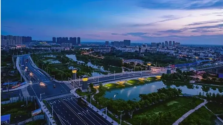
Photo adjustments
EXIF orientation normalized; resized without changing aspect ratio; converted to WebP. No subject edits.
- Administrative area
- County-level city · 县级市
- Part of
- Wuhu
- Chinese name
- 无为市
- Local areas
- County-level city guide
Area & population
- Area in the source
- 2,022.00 km²
- Population · 2020
- 817,997
- Administrative seat
- Wucheng (无城镇)
Source: cited geographic source, as of the dates shown.
Setting and landscape
Hills curve around the northwest and waters gather in the southeast, and the area has long been called a "land of fish and rice". Before the Yangtze levee was built, a strip more than ten kilometres deep along the north bank was river floodplain.
History
Finds at the Baiheguan site in Xiang'an (襄安白鹤观遗址) take local history back to the Shang and Zhou, and the small state of Shuyong (舒庸国) stood around today's Yaogou town (姚沟镇). In the Three Kingdoms, Cao Cao (曹操) won two battles at Ruxukou (濡须口) in his campaigns against Wu. The Sui set up Wucheng town, the Northern Song created the Wuwei military prefecture (无为军), and Wuwei County followed in 1070. One old account says the name, literally "no action", recalls Cao Cao building a fort here and failing against Sun Quan (孙权); another links it to the Song ideal of peaceful rule.
The painter and calligrapher Mi Fu (米芾) governed the prefecture for three years. In the war against Japan the area was the centre of the Wanjiang (皖江) base area, and during the civil war it was where the "first boat across the river" set out.
What to see
The Mi Gong Shrine (米公祠) grew up on the site of Mi Fu's study, the Baojin Studio (宝晋斋), named for the Jin-dynasty calligraphy he kept there, with an ink pond in front. Its old collection was mostly lost; a relics office there now keeps over 100 inscribed steles, including regular-script writing by Emperor Huizong of Song (宋徽宗) and seal script by Mi Fu. The shrine was listed provincially in 1981. The Golden Pagoda (黄金塔), a nine-storey, 37-metre brick tower in imitation timber style, stands on Fenghuang hill 5 km northeast of Wucheng. The former headquarters of the New Fourth Army's Seventh Division (新四军七师师部旧址) lies at Sanshuijian (三水涧), 15 km northwest of Wucheng.
Food and local products
Wuwei salted duck (无为板鸭), made for more than 200 years, is known for its golden colour and rich but not greasy taste. Wuwei crabs gained national geographical indication status in 2014, and water chestnuts and lotus root are traditional crops. Gauze lanterns with ink-cut designs (剔墨纱灯) were first made by Cai Jing (蔡静) of Wuwei in the Kangxi reign; for the tenth National Day they hung in the Anhui Hall of the Great Hall of the People.
Getting oriented
The Beijing–Fuzhou and Shangqiu–Hefei–Hangzhou high-speed railways cross the city, as do the Lujiang–Tongling railway and the Wuhu–Tongling and North Yangtze expressways.
Highlights
- Mi Gong Shrine 米公祠: Built on the site of Mi Fu's Baojin Studio; over 100 inscribed steles are kept on the site.
- Golden Pagoda 黄金塔: Nine-storey, 37-metre brick pagoda on Fenghuang hill northeast of Wucheng.
- Former HQ of the New Fourth Army Seventh Division 新四军七师师部旧址: At Sanshuijian, 15 km northwest of Wucheng; provincial protected site.
- Wuwei salted duck 无为板鸭: Golden, rich but not greasy; made for over 200 years.
- Ink-cut gauze lanterns 剔墨纱灯: Created by Cai Jing in the Kangxi reign.
Sources for this guide
无为简介_无为市人民政府 · Wuwei City People's Government
无为历史演变_无为市人民政府 · Wuwei City People's Government
特色物产_无为市人民政府 · Wuwei City People's Government
无为市 - 维基百科,自由的百科全书 · Wikipedia (Chinese) · CC BY-SA 4.0
Original English written from the listed sources and checked sentence by sentence against quoted extracts by a separate reviewer. Updated 2026-09-23.
Explore Wuwei City
Core places to explore, with English and Chinese names.
Wuwei City 无为市
Plan your visit
Getting there
Wuwei City is about 50 km in a straight line from central Wuhu. Search for 无为市 in a map app to find stations and your accommodation.
Where to stay →More in Wuhu
Sources & geographic information
Administrative names and parent areas: Official geographic directory · Reference date 2026-09-06.
Some facts checked against 无为市 — Wikipedia contributors, CC BY-SA 4.0.
Map data © OpenStreetMap contributors. Pins mark approximate centres, not entrances or boundaries.