


Get to know Guangde
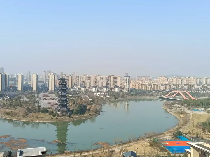
Photo adjustments
Full frame retained; proportionally resized and converted to WebP. No retouching or changes to the photographed subject. Card displays may crop the view.
- Administrative area
- County-level city · 县级市
- Part of
- Xuancheng
- Chinese name
- 广德市
- Local areas
- County-level city guide
Area & population
- Area in the source
- 2,165.00 km²
- Population · 2019
- 508,000
Source: cited geographic source, as of the dates shown.
Setting and landscape
Guangde lies where the mountains of southern Anhui give way to the plains along the Yangtze. The south is low mountain country cut by gorges, with its highest point on Ma'anshan (马鞍山) at 863.3 metres; the middle is a basin of low ridges and valley plains; and in the north, thick pure limestone holds subtropical karst caves. The Tongrui River (桐汭河) and the Wuliang Stream (无量溪) run south to north across the city and join in Langxi County (郎溪县) as the Langchuan River (郎川河), which flows into Nanyi Lake (南漪湖). Guangde is titled a home of bamboo and of chestnuts.
History
The old name of Guangde is Tongrui (桐汭). The Sun Wu (孙吴) regime created the county early in the Jian'an (建安) era, more than 1,800 years ago, choosing a name that proclaimed the breadth of imperial virtue. In 979 the Song made it the seat of Guangde Military Prefecture (广德军), and Zhu Yuanzhang (朱元璋) took the area in 1356. Guangde became a county-level city in 2019.
In March 1960 the Guangde rocket launch site, known as Base 603, was built at Shijie (誓节镇). It is described as the birthplace of China's sounding rockets, and on its last two launches, on 15 and 28 July 1966, two dogs were sent up and brought back. Cishan culture (祠山文化) grew from worship of the flood-taming hero Zhang Bo (张渤), centred on Hengshan (横山); the legend of Zhang Bo is on the county intangible heritage list.
What to see
The Taiji Cave, which the city government calls the largest karst cave in East China, carries the inscription "four wonders under heaven" (天下四绝) at its mouth; in 2021 it was Guangde's only 4A scenic area. The Lingshan Grand Canyon (灵山大峡谷) was then graded 3A and Hengshan National Forest Park (横山国家森林公园) 2A. Other well-known sights include the Tianshou Temple Pagoda (天寿寺塔) and the Drum-Horn Tower (鼓角楼). In the southern hills, the man-made Lu Lake (卢湖) sits among large bamboo forests.
Food and local products
Guangde's "four delicacies" (广德四绝) were Tonghua fish (桐花鱼), Hengshan pheasant (横山雉), Jishan bamboo shoots (笄山笋) and Shahe soft-shelled turtle (沙河鳖). After the pheasant disappeared, a salted vegetable called "Guangde's first freshness" (广德第一鲜) took its place. Yunwu (云雾) tea won a gold medal at the Panama-Pacific exposition in San Francisco.
Getting oriented
The Shangqiu–Hefei–Hangzhou high-speed railway (商合杭高铁), the Xuancheng–Hangzhou railway (宣杭铁路) and the G50 expressway pass through the city.
Highlights
- Taiji Cave 太极洞: Called the largest karst cave in East China by the city government; the only 4A scenic area in Guangde in 2021.
- Hengshan National Forest Park 横山国家森林公园: Graded a 2A scenic area as of 2021.
- Tianshou Temple Pagoda 天寿寺塔: Listed among Guangde's well-known sights.
- Jishan bamboo shoots 笄山笋: One of Guangde's traditional four delicacies.
- Yunwu tea 云雾茶: Won a gold medal at the Panama-Pacific exposition in San Francisco.
Sources for this guide
市情简介-广德市人民政府 · Guangde Municipal People's Government
交通区位-广德市人民政府 · Guangde Municipal People's Government
历史文化-广德市人民政府 · Guangde Municipal People's Government
广德市 - 维基百科,自由的百科全书 · Wikipedia (Chinese) · CC BY-SA 4.0
Original English written from the listed sources and checked sentence by sentence against quoted extracts by a separate reviewer. Updated 2026-09-23.
Explore Guangde
Core places to explore, with English and Chinese names.
Places to explore around Guangde
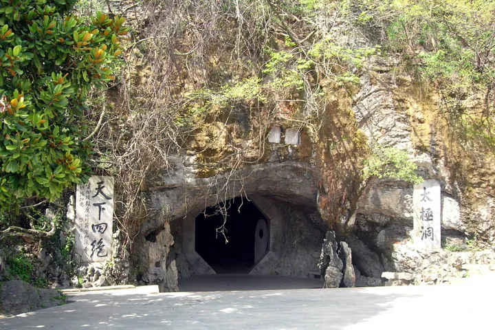 The rock-cut entrance to Taiji Cave, inscribed with the cave's name, in Guangde City, Xuancheng. ·
 Plan your visit
Getting there
Guangde is about 65 km in a straight line from central Xuancheng. Search for 广德市 in a map app to find stations and your accommodation.
Where to stay →Build your route
Start with Taiji Cave. The linked place guides have entrance and visit details.
Continue with Xuancheng →More in Xuancheng
Sources & geographic information
Administrative names and parent areas: Official geographic directory · Reference date 2026-09-06.
Some facts checked against 广德市 — Wikipedia contributors, CC BY-SA 4.0.
Photo: Taiji Cave · luchangjiang~鲁昌江 · CC BY-SA 3.0. Full frame retained; proportionally resized and converted to WebP. No retouching or changes to the photographed subject. Card displays may crop the view.

Map data © OpenStreetMap contributors. Pins mark approximate centres, not entrances or boundaries.