


Get to know Jixi County
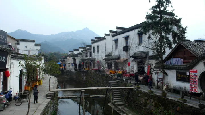
Photo adjustments
Full frame retained; proportionally resized and converted to WebP. No retouching or changes to the photographed subject. Card displays may crop the view.
- Administrative area
- County · 县
- Part of
- Xuancheng
- Chinese name
- 绩溪县
- Local areas
- County guide
Area & population
- Area in the source
- 1,126.00 km²
- Population · 2019
- 159,000
Source: cited geographic source, as of the dates shown.
Setting and landscape
Jixi sits where the Huangshan and Tianmu (天目山) ranges meet, on the divide between the Yangtze and Qiantang (钱塘江) river systems. The Xin'an (新安江), Qingyi (青弋江) and Shuiyang (水阳江) rivers all rise here. The county counts 46 peaks above 1,000 metres; the highest, Qingliang Peak (清凉峰) on Mount Dazhang (大鄣山), reaches 1,787.4 metres and is described by the county government as the second-highest peak in East China.
The name comes from water: the county annals, as quoted by the government, say two streams north of the town, the Ru (乳溪) and the Hui (徽溪), run side by side, part and rejoin like spun thread, the meaning of ji ("绩", to spin).
History
A Liang'an County (良安县) was set up here in 535, and Jixi County itself dates from 766 under the Tang. Jixi belonged to Shezhou (歙州) until 1121, when the prefecture was renamed Huizhou, a name the county government links to Jixi's Hui Pass (徽岭), Hui Stream and Dahui village (大徽村). When Anhui province was created in 1667, its name joined the first characters of Anqing and Huizhou, which is why the county calls itself the source of Anhui. Jixi was placed under Xuancheng Prefecture in 1988.
What to see
Longchuan (龙川) is a 5A scenic area built around a boat-shaped village where the Longchuan stream joins the Dengyuan River (登源河). Its Hu Ancestral Hall (胡氏宗祠) was listed as a national protected site in 1988 and is known for carved door panels of lotus motifs; the Yishi Shangshu memorial arch (奕世尚书坊) dates from the Jiajing reign of the Ming.
The Huizhou-Hangzhou Ancient Road (徽杭古道) in the east of the county was first built in the Tang and runs about 20 kilometres through the Qingliangfeng national nature reserve. Zhangshan Grand Canyon (鄣山大峡谷), the southern gateway to the same reserve, is a valley of pools, rapids and waterfalls among rock formations. In the west, Shangzhuang (上庄), home of Hu Shi (胡适), keeps a well-preserved group of Huizhou-style buildings. The Jixi Confucian temple (绩溪文庙) was first built in the Song, and the Ming-dynasty Zhou Ancestral Hall (周氏宗祠) now houses the county's museum of stone, wood and brick carving.
Food and local products
The county government says Hui cuisine, one of China's eight major cuisines, grew out of Jixi's village cooking, and it names Shangzhuang the home of the 'yipinguo' (一品锅, 'first-rank pot'). The county also points to the 'globe ink' (地球墨) of the Hu Kaiwen ink works (胡开文墨庄), which won a gold medal at the Panama-Pacific Exposition.
Highlights
- Longchuan Scenic Area 龙川景区: 5A scenic area with the Hu Ancestral Hall, a national protected site since 1988.
- Huizhou-Hangzhou Ancient Road 徽杭古道: Tang-era trading path of about 20 km through the Qingliangfeng reserve.
- Zhangshan Grand Canyon 鄣山大峡谷: Canyon of pools and waterfalls at the southern gate of the Qingliangfeng reserve.
- Shangzhuang Village 上庄村: Home of Hu Shi, with a well-preserved Huizhou-style building group.
Sources for this guide
绩溪县县情简介-绩溪县人民政府 · Jixi County People's Government
龙川景区(AAAAA)-绩溪县人民政府 · Jixi County Culture and Tourism Bureau, via the Jixi County People's Government portal
徽杭古道景区(AAAA)-绩溪县人民政府 · Jixi County Culture and Tourism Bureau, via the Jixi County People's Government portal
鄣山大峡谷景区(AAAA)-绩溪县人民政府 · Jixi County Culture and Tourism Bureau, via the Jixi County People's Government portal
上庄景区(AAA)-绩溪县人民政府 · Jixi County Culture and Tourism Bureau, via the Jixi County People's Government portal
Original English written from the listed sources and checked sentence by sentence against quoted extracts by a separate reviewer. Updated 2026-09-25.
Explore Jixi County
Core places to explore, with English and Chinese names.
Places to explore around Jixi County
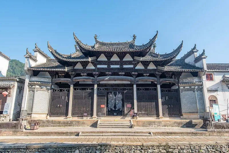 Jixi Longchuan Scenic Area (绩溪龙川景区), Jixi County. Photograph: "Longchuan Village, 2021-09-27 06".
Jixi Longchuan Scenic Area绩溪龙川景区
Longchuan is a historic village destination in Jixi, with ancestral architecture, memorial stonework and a water-side street.
Read the place guide → Huihang Ancient Trail · 徽杭古道
Huihang Ancient Trail徽杭古道
Tang-dynasty Huizhou merchants' path from Jixi County, Anhui, towards Hangzhou, now a hiking route over the Jiangnan First Pass.
Read the place guide →Longchuan Village (龙川), Jixi County. Photograph: "Longchuan Village, 2021-09-27 06".Longchuan Village龙川
Longchuan is a Hu-clan village in Yingzhou, Jixi County, where an ancestral hall and a stone memorial arch frame a settlement beside the Dengyuan River.
Read the place guide → Shangzhuang Village · 上庄村
Shangzhuang Village上庄村
Shangzhuang is a riverside village in Jixi County whose houses connect the childhood of scholar Hu Shi with the local tradition of ink making.
Read the place guide →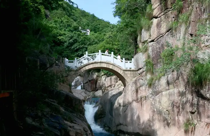 Zhangshan Grand Canyon · 鄣山大峡谷
Zhangshan Grand Canyon鄣山大峡谷
Zhangshan Grand Canyon lies in Fuling Town, Jixi County, where a stream threads between conspicuous rock formations below the southern approach to Qingliangfeng.
Read the place guide →Plan your visit
Getting there
Jixi County is about 100 km in a straight line from central Xuancheng. Search for 绩溪县 in a map app to find stations and your accommodation.
Where to stay →Build your route
Jixi Longchuan Scenic Area and Huihang Ancient Trail are both listed here. The linked place guides have entrance and visit details.
Continue with Xuancheng →More in Xuancheng
Sources & geographic information
Administrative names and parent areas: Official geographic directory · Reference date 2026-09-06.
Photo: Jixi Longchuan Scenic Area · Siyuwj · CC BY-SA 4.0. Full frame retained; EXIF orientation normalized, proportionally resized to at most 800 pixels and converted to WebP. No generated pixels or subject changes. Cards may crop the display.

Photo: Huihang Ancient Trail · 三猎 · CC BY-SA 4.0. EXIF orientation normalized; resized without changing aspect ratio; converted to WebP. No subject edits.

Photo: Longchuan Village · Siyuwj · CC BY-SA 4.0. Full frame retained; EXIF orientation normalized, proportionally resized to at most 800 pixels and converted to WebP. No generated pixels or subject changes. Cards may crop the display.
Photo: Shangzhuang Village · 猫猫的日记本 · CC BY-SA 4.0. EXIF orientation normalized; resized without changing aspect ratio; converted to WebP. No subject edits.

Photo: Zhangshan Grand Canyon · Source photographer · License not provided. EXIF orientation normalized; resized without changing aspect ratio; converted to WebP. No subject edits.
Map data © OpenStreetMap contributors. Pins mark approximate centres, not entrances or boundaries.