

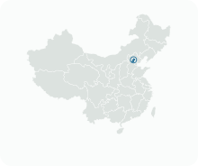
Get to know Shunyi District

Photo adjustments
Full frame retained; proportionally resized and converted to WebP. No retouching or changes to the photographed subject. Card displays may crop the view.
- Administrative area
- District · 市辖区
- Part of
- Beijing
- Chinese name
- 顺义区
- Local areas
- District guide
Area & population
- Area in the source
- 1,020.00 km²
- Population · 2020
- 1,324,044
Source: cited geographic source, as of the dates shown.
Setting and landscape
The district borders Huairou (怀柔区) and Miyun (密云区) to the north, Pinggu (平谷区) to the east, Tongzhou (通州区) and Sanhe (三河市) in Hebei to the south, and Chaoyang (朝阳区) and Changping (昌平区) to the southwest and west, where the Wenyu River (温榆河) forms the boundary. The Yan Mountains (燕山) screen the northeastern edge. Flood-laid sand and sandy loam form the plain, which covers 95.7 per cent of the area. The land is higher in the north: the highest point, in the northern hills, is 637 metres, and the average elevation is 35 metres.
The climate is a continental, semi-humid monsoon type with four distinct seasons. Annual rainfall is around 625 millimetres, three quarters of it in summer.
History
Under the Western Han, between 202 and 195 BC, two counties, Hunu (狐奴) and Anle (安乐), were set up here under Yuyang Commandery (渔阳郡). In 648, under the Tang, the Guishun prefecture (归顺州) was created for a Khitan (契丹) group that had submitted to the dynasty; it was renamed Guihua Commandery in 742 and became Guishun again in 758.
In the twelfth month of 1368 the Ming reduced Shunzhou to Shunyi County, first under Beiping and later under Shuntian prefecture. The county became part of the Jingzhao special district in 1914 and of Hebei province in 1928, and its county town was taken by the People's Liberation Army on 8 December 1948. Shunyi was transferred to Beijing in April 1958, and in December 1998 the State Council approved turning the county into a district.
What to see
Shunyi Olympic Rowing-Canoeing Park (顺义奥林匹克水上公园), in Mapo (马坡), was built for rowing, canoeing and the 10-kilometre open-water swim of the 2008 Beijing Olympics. Its pump-fed slalom channel is 300 metres long with a drop of 6.3 metres and draws its water from the long rectangular rowing lake. The park and the Jianhe Park (顺义减河公园) both lie along the Chaobai River.
Terminal 3 of the capital airport is administratively part of Shunyi, while Terminals 1 and 2, although surrounded by the district, belong to Chaoyang as an exclave. The headquarters of Air China (国航) and of the Yanjing (燕京) brewery are also in the district.
Getting oriented
Beijing Subway Line 15 and the Capital Airport Express serve the district, which also has Shunyi and Shunyi West railway stations. Expressways crossing it include the Jingcheng (京承高速), Jingping (京平高速) and Second Airport Expressway (机场第二高速).
Highlights
- Shunyi Olympic Rowing-Canoeing Park 顺义奥林匹克水上公园: Venue for rowing, canoeing and marathon swimming at the 2008 Olympics, with a 300-metre pumped slalom channel.
- Chaobai River 潮白河: Runs north to south through the district; the Olympic water park and Jianhe Park lie along it.
- Beijing Capital International Airport Terminal 3 首都机场3号航站楼: Administratively part of Shunyi, unlike Terminals 1 and 2.
Sources for this guide
顺义概况 - 北京市顺义区人民政府 · Shunyi District People's Government, Beijing
自然环境 - 北京市顺义区人民政府 · Shunyi District People's Government, Beijing
沿革简史 - 北京市顺义区人民政府 · Shunyi District People's Government, Beijing
顺义区 - 维基百科 · Wikipedia (Chinese) · CC BY-SA 4.0
Shunyi Olympic Rowing-Canoeing Park - Wikipedia · Wikipedia (English) · CC BY-SA 4.0
Original English written from the listed sources and checked sentence by sentence against quoted extracts by a separate reviewer. Updated 2026-09-23.
Explore Shunyi District
Core places to explore, with English and Chinese names.
Places to explore around Shunyi District
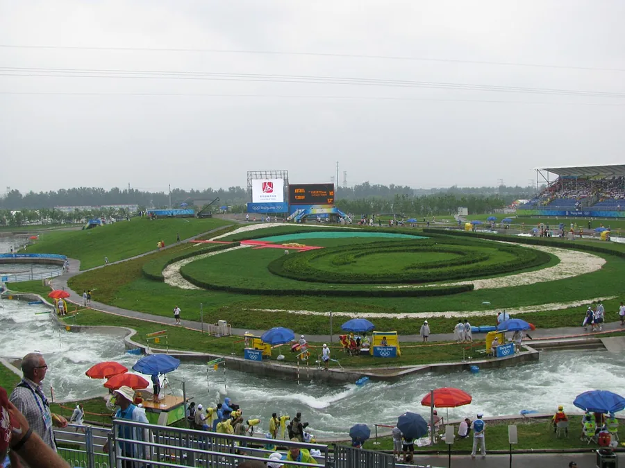 Gates 16–19 of the Shunyi Olympic slalom course during the Beijing Games, 10 August 2008.
Shunyi Olympic Rowing-Canoeing Park顺义奥林匹克水上公园
Shunyi Olympic Rowing-Canoeing Park preserves the water-sports setting built for Beijing’s 2008 Games. The long rowing water and the pumped slalom course were designed for very different kinds of competition, making their…
Read the place guide →Gates 16–19 of the Shunyi Olympic slalom course during the 2008 Beijing Games · 顺义奥林匹克水上公园激流回旋赛道. Source-recorded photograph date: 2008-08-10.Shunyi Olympic Rowing-Canoeing Park奥林匹克水上公园
Shunyi Olympic Rowing-Canoeing Park preserves a water-sports setting created for the 2008 Beijing Games.
Read the place guide →Plan your visit
Getting there
Shunyi District is about 35 km in a straight line from central Beijing. Search for 顺义区 in a map app to find stations and your accommodation.
Where to stay →Build your route
Start with Shunyi Olympic Rowing-Canoeing Park. The linked place guides have entrance and visit details.
Continue with Beijing →More in Beijing
Sources & geographic information
Administrative names and parent areas: Official geographic directory · Reference date 2026-09-06.
Some facts checked against 顺义区 — Wikipedia contributors, CC BY-SA 4.0.
Some facts checked against Shunyi Olympic Rowing-Canoeing Park — Wikipedia contributors, CC BY-SA 4.0.
Photo: Shunyi Olympic Rowing-Canoeing Park · Gerry Boudens · CC BY-SA 3.0. Proportionally resized and converted to WebP without cropping, retouching or changing the photographed subject.

Photo: Shunyi Olympic Rowing-Canoeing Park · Gerry Boudens · CC BY-SA 3.0. Full source framing retained; proportionally resized and converted to WebP. No retouching or subject alteration. Card displays may crop the view.
Map data © OpenStreetMap contributors. Pins mark approximate centres, not entrances or boundaries.