


Get to know Longnan
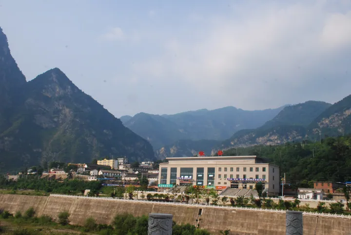
Photo adjustments
Full frame retained; proportionally resized and converted to WebP. No retouching or changes to the photographed subject. Card displays may crop the view.
- Administrative area
- Prefecture-level city · 地级市
- Part of
- Gansu
- Chinese name
- 陇南市
- Local areas
- 9 local areas
Area & population
- Area in the source
- 27,890.00 km²
- Population · 2020 census
- 2,407,272
- Administrative seat
- Wudu District
Source: cited geographic source, as of the dates shown.
Setting and landscape
The average elevation is about 1,000 m, but the land falls from Xionghuang Mountain (雄黄山, 4,187 m) in northwestern Wen County (文县) to Guanzi Gully (罐子沟, 550 m) in the county's southeast, Gansu's lowest point according to the city government. The Jialing (嘉陵江), Bailong (白龙江), Baishui (白水江) and Xihan (西汉水) rivers drain it, and the climate is transitional between subtropical and north temperate. In the Yuhe National Nature Reserve (裕河国家级自然保护区) in Wudu (武都), a boardwalk lets walkers watch Sichuan golden monkeys.
History
People lived here more than 7,000 years ago. The city government calls Longnan the cradle of the Qin: Li County (礼县) on the upper Xihan River was the old Qin territory of Xichui (西垂), and its Dabuzishan site (大堡子山遗址) is identified as the Xichui mausoleum, the first of four Qin royal cemeteries. The Han created Wudu Commandery in 111 BC, and Wei and Shu fought repeatedly here. From 296, when the Di (氐) leader Yang Maosou (杨茂搜) founded Qiuchi (仇池), Di and Qiang (羌) rulers held five local states for more than 300 years. The Red Army's three main forces each rested at Hadapu (哈达铺) in Tanchang County (宕昌县), where they chose to march on to northern Shaanxi. Wudu Prefecture was renamed Longnan in 1985.
The Qiqiao (乞巧) festival and Gaoshan opera (高山戏) are on the national intangible heritage list.
What to see
The Xixia Song (西狭颂), a cliff inscription of 171 AD in Han clerical script praising the Wudu governor Li Xi (李翕), is cut into a gorge at Tianjingshan (天井山) in Cheng County (成县), beside pools and waterfalls. Guan'egou (官鹅沟) in Tanchang is a 5A scenic area of streams and waterfalls, Yunhua Mountain (云华山) in Xihe County (西和县) has Danxia landforms, and the Gansu Qin Culture Museum (甘肃秦文化博物馆) holds early Qin bronzes.
Food and local products
Wudu potato jiaotuan (武都洋芋搅团), made from local potatoes, is eaten hot in sour jiangshui (浆水) broth with salt and chili oil, or cold in a soup of vinegar, garlic and chili. Wudu mipi (武都米皮) are steamed from rice batter on oiled trays, cut into 2 cm strips and topped with pickled tuber, salted greens, crisp soybeans and scallions. The warmer Kang (康县), Wudu and Wen areas suit codonopsis, angelica, olives, tea and Dahongpao Sichuan pepper (大红袍花椒).
Getting oriented
The city government sits in Wudu District. The Lanzhou–Chongqing railway crosses the prefecture with stations at Longnan and Hadapu, and Longnan Chengxian Airport serves the area.
Highlights
- Xixia Song 西狭颂: Composed and written by Qiu Jing (仇靖); 385 characters in 12 lines, with a panel of five auspicious omens.
- Guan'egou 官鹅沟: National 5A scenic area with the Guan'e waterfall and a cable car up Leigu Mountain (雷古山).
- Gansu Qin Culture Museum 甘肃秦文化博物馆: Museum of early Qin relics, including bronzes, in the region the city government calls the Qin homeland.
- Jifeng Mountain 鸡峰山: National forest park whose summit overlooks the Hui–Cheng basin (徽成盆地).
Sources for this guide
陇南简介 - 陇南市人民政府 · Longnan Municipal People's Government
地理概况 - 陇南市人民政府 · Longnan Municipal People's Government
历史沿革 - 陇南市人民政府 · Longnan Municipal People's Government
武都洋芋搅团_陇南市人民政府 · Longnan Municipal People's Government
武都米皮_陇南市人民政府 · Longnan Municipal People's Government
陇南市 - 维基百科,自由的百科全书 · Wikipedia (Chinese) · CC BY-SA 4.0
西狭颂摩崖石刻 - 维基百科,自由的百科全书 · Wikipedia (Chinese) · CC BY-SA 4.0
清凉陇南,盛夏三巡(山水攻略篇)_陇南市人民政府 · Longnan Municipal Culture, Radio, Television and Tourism Bureau (city government portal)
Original English written from the listed sources and checked sentence by sentence against quoted extracts by a separate reviewer. Updated 2026-09-30.
Explore Longnan
Core places to explore, with English and Chinese names.
Guan'egou 官鹅沟
Wanxiang Cave 万象洞
Hadapu Red Army Long March Memorial Hall 哈达铺红军长征纪念馆
Yangba Ecological Scenic Area 阳坝
Xixia Song Cliff Inscription 西狭颂
Wenxian Tianchi Lake 文县天池
Baima Tibetan Villages Tielou Area 白马藏族村寨铁楼片区
Gansu Qin Culture Museum 甘肃秦文化博物馆
Wanxia Lake 晚霞湖
Wudu District 武都区
Cheng County 成县
Wen County 文县
Tanchang County 宕昌县
Kang County 康县
Xihe County 西和县
Li County 礼县
Hui County 徽县
Liangdang County 两当县
Places to explore around Longnan
 AI illustration · AI 示意图(仅供参考,非该地点实拍)
Guan'egou官鹅沟
Guanegou combines two separately accessed valley sectors, Guanzhu and Eman. Waterfalls and narrow cliff passages define Guanzhu, while Eman adds lakes and Tibetan village scenery to the mountain setting. Names such as Jiudie…
Read the place guide → Wanxiang Cave · 万象洞
Wanxiang Cave万象洞
Wanxiang Cave extends into the hillside above the Bailong River near Wudu. Stalactites, stalagmites, columns and curtain-like deposits fill a managed sequence of chambers, traditionally grouped under the names Moon Palace…
Read the place guide → Hadapu Red Army Long March Memorial Hall · 哈达铺红军长征纪念馆
Hadapu Red Army Long March Memorial Hall哈达铺红军长征纪念馆
The Hadapu Long March Memorial Hall (哈达铺红军长征纪念馆) is a memorial in Hadapu town, Dangchang County, Longnan, Gansu, standing on the town's main street on National Highway 212, 35 km south of the county town.
Read the place guide → Yangba Ecological Scenic Area · 阳坝
Yangba Ecological Scenic Area阳坝
The Kangxian Yangba ecological tourism scenic area (康县阳坝生态旅游风景区) lies in the south-east of Kang County, Longnan, Gansu, and the Gansu Economic Information Network page gives it a total area of 504.93 sq km, most of it primary forest.
Read the place guide → Xixia Song Cliff Inscription · 西狭颂
Xixia Song Cliff Inscription西狭颂
Eastern Han cliff text of AD 171 west of Cheng County, Gansu, praising a governor's road through the gorge; one of the Three Han Eulogies.
Read the place guide → AI illustration · AI 示意图(仅供参考,非该地点实拍)
Wenxian Tianchi Lake文县天池
Wenxian Tianchi (文县天池), also called Yangtang Tianchi, is a lake on Tianwei Mountain about 90 km south-west of Wudu District in Longnan, Gansu, which a Xinhua Gansu Channel piece of November 2024 describes as known for three features.
Read the place guide → Baima Tibetan Villages Tielou Area · 白马藏族村寨铁楼片区
Baima Tibetan Villages Tielou Area白马藏族村寨铁楼片区
Tielou Tibetan township (铁楼藏族乡) in Wen County, Longnan, Gansu, is described by a Xinhua feature of January 2022 as a settlement area of the Baima Tibetans, descendants of the ancient Di people with a total population of about 20,000.
Read the place guide → AI illustration · AI 示意图(仅供参考,非该地点实拍)
Gansu Qin Culture Museum甘肃秦文化博物馆
The Gansu Qin Culture Museum (甘肃秦文化博物馆) stands at Qinren Square on Dongxin South Road in Chengguan town, Li County, Longnan, Gansu, and was built to hold and display the county's early Qin material.
Read the place guide →AI illustration · AI 示意图(仅供参考,非该地点实拍)Wanxia Lake晚霞湖
Wanxia Lake (晚霞湖) is a reservoir and scenic area in Jiangxi town, 5 km west of Xihe county town in Longnan, Gansu, which the China Gansu Net page calls one of the city's ten key tourist sights.
Read the place guide →Local life & food
Longnan local specialties
陇南市特色美食 · 12 specialties to discover
 Longnan jiangtuan 陇南搅团AI illustration · AI 示意图
The staple is soft, cohesive and gently grain-flavored, while the accompanying liquid supplies acidity, salt and chili.
Source ↗Read the dish guide → Wenxian Baima ten-bowl feast 文县白马十大碗AI dish illustration / AI 菜品示意图
The meal varies its textures and seasoning across bowls, with lighter soups balancing richer meat dishes.
Source ↗Read the dish guide →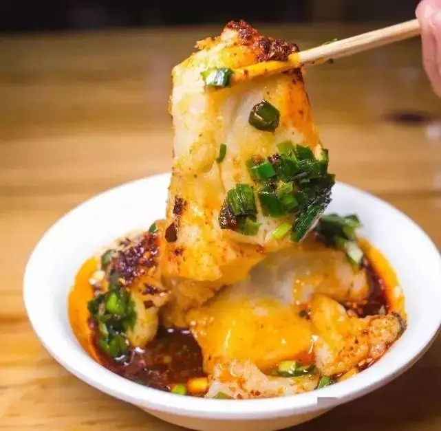 Wudu Pounded Potato Mash 武都洋芋搅团
Wudu Pounded Potato Mash (武都洋芋搅团) is boiled local potato pounded into a springy paste, which the Longnan (陇南) city government lists as a famous snack of Wudu (武都), served hot in sour pickled-vegetable water or cold in a vinegar broth.
Read the dish guide →Photo adjustments
EXIF orientation normalized; resized without changing aspect ratio; converted to WebP. No subject edits.
 Wudu Cold Rice Noodle Strips 武都米皮AI illustration · AI 示意图(仅供参考,非实拍)
Wudu Cold Rice Noodle Strips (武都米皮) are sheets of steamed rice batter cut into strips and dressed, a street snack of Wudu (武都) in Longnan (陇南), Gansu.
Read the dish guide →Li County Hot Noodle Sheets 礼县热面皮AI illustration · AI 示意图(仅供参考,非实拍)
Li County Hot Noodle Sheets (礼县热面皮) are steamed wheat-flour sheets served warm with wheat gluten and a heavy dose of chilli in Li County (礼县), Longnan (陇南), Gansu.
Read the dish guide → Xihe Thick Flatbread 西和锅盔AI illustration · AI 示意图(仅供参考,非实拍)
Xihe Thick Flatbread (西和锅盔) is a round wheat loaf 8 to 10 centimetres thick, baked slowly over charcoal and a wheat-straw fire, and the Xihe County (西和县) government in Longnan (陇南) lists it as a local speciality known for keeping well and travelling easily.
Read the dish guide → Cheng County Savory Oil Tea 成县油茶AI illustration · AI 示意图(仅供参考,非实拍)
Cheng County Savory Oil Tea (成县油茶) is a hot, savoury oil tea from Cheng County (成县) in Longnan (陇南), Gansu, where it is served with fried dough twists as youcha mahua ("油茶麻花", oil tea with dough twists).
Read the dish guide → Kang County Clay Jar Tea 康县罐罐茶AI illustration · AI 示意图(仅供参考,非实拍)
Kang County Clay Jar Tea (康县罐罐茶) is the pot-boiled tea of Kang County (康县) in Longnan (陇南), Gansu, where tea leaves are simmered with salt and spices, thickened with roasted wheat flour and topped with egg, tofu, potato, dough twists, walnuts and pork cracklings.
Read the dish guide →All dish names · 全部菜名 (12)
- Longnan jiangtuan · 陇南搅团
- Wenxian Baima ten-bowl feast · 文县白马十大碗
- Wudu Pounded Potato Mash · 武都洋芋搅团
- Wudu Cold Rice Noodle Strips · 武都米皮
- Li County Hot Noodle Sheets · 礼县热面皮
- Xihe Thick Flatbread · 西和锅盔
- Cheng County Savory Oil Tea · 成县油茶
- Kang County Clay Jar Tea · 康县罐罐茶
- Wen County Meat Boiled in Zagan Wine · 文县咂杆酒煮肉
- Dangchang Hadapu Pounded Potato Mash · 宕昌哈达铺洋芋搅团
- Hui County Tofu Pudding · 徽县豆腐脑
- Liangdang Langya Honey Cake · 两当狼牙蜜糕
More dishes from across Gansu are in the Gansu food guide.
Counties & districts in Longnan
9 areas belong directly to Longnan.
9 areas
Wudu District武都区
Wudu District is a district and the political and cultural center of Longnan, Gansu province, China. It borders the provinces of Shaanxi province and Sichuan to the southeast.
Explore the area →CountyCheng County成县
Cheng County or Chengxian (simplified Chinese: 成县; traditional Chinese: 成縣; pinyin: Chéng Xiàn) is a county under the administration of Longnan City, in southeastern Gansu Province of China.
Explore the area →CountyWen County文县
Wen County or Wenxian is a county under the administration of the prefecture-level city of Longnan, in the southeast of Gansu province, China, bordering Sichuan province to the south and west.
Explore the area →CountyTanchang County宕昌县
Tanchang, also pronounced Dàngchāng, is a county in the south of Gansu province, China. It is the westernmost county-level division of the prefecture-level city of Longnan.
Explore the area →Show fewer areas
Kang County康县
Kang County or Kangxian (simplified Chinese: 康县; traditional Chinese: 康縣; pinyin: Kāng Xiàn) is a county in the southeast of Gansu province, China. It is under the administration of Longnan City.
Explore the area →CountyXihe County西和县
Xihe County is a county under the administration of the prefecture-level city of Longnan, in the southeast of Gansu Province of China. The postal code is 742500.
Explore the area →CountyLi County礼县
Li County or Lixian is an administrative division of the prefecture-level city of Longnan in southeastern Gansu, a northwestern province of China.
Explore the area →CountyHui County徽县
Hui County or Huixian (simplified Chinese: 徽县; traditional Chinese: 徽縣; pinyin: Huī Xiàn) is a county under the administration of Longnan City, in the southeast of Gansu Province, China, bordering Shaanxi…
Explore the area →CountyLiangdang County两当县
Liangdang County (simplified Chinese: 两当县; traditional Chinese: 兩當縣; pinyin: Liǎngdāng Xiàn) is a county under the administration of Longnan City, in the southeast of Gansu Province of China.
Explore the area →No areas match this name.
Plan your visit
Getting there
Search for 陇南市 in a map app to find stations and your accommodation.
Where to stay →Build your route
Guan'egou and Wanxiang Cave are about 90 km apart in a straight line. The linked place guides have entrance and visit details.
Continue with Gansu →More in Gansu
Sources & geographic information
Administrative names and parent areas: Official geographic directory · Reference date 2026-09-06.
Some facts checked against 陇南市 — Wikipedia contributors, CC BY-SA 4.0.
Some facts checked against 西狭颂摩崖石刻 — Wikipedia contributors, CC BY-SA 4.0.
Photo: Wanxiang Cave · Source photographer · License not provided. EXIF orientation normalized; resized without changing aspect ratio; converted to WebP. No subject edits.
Photo: Hadapu Red Army Long March Memorial Hall · Source photographer · License not provided. EXIF orientation normalized; resized without changing aspect ratio; converted to WebP. No subject edits.
Photo: Yangba Ecological Scenic Area · Source photographer · License not provided. EXIF orientation normalized; resized without changing aspect ratio; converted to WebP. No subject edits.
Photo: Xixia Song Cliff Inscription · Source photographer · License not provided. EXIF orientation normalized; resized without changing aspect ratio; converted to WebP. No subject edits.
Photo: Baima Tibetan Villages Tielou Area · Source photographer · License not provided. EXIF orientation normalized; resized without changing aspect ratio; converted to WebP. No subject edits.
Map data © OpenStreetMap contributors. Pins mark approximate centres, not entrances or boundaries.