


Get to know Liangdang County
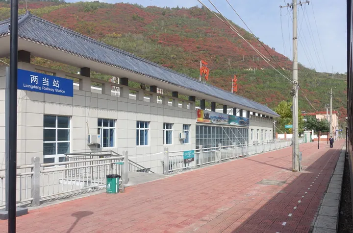
Photo adjustments
Full frame retained; proportionally resized and converted to WebP. No retouching or changes to the photographed subject. Card displays may crop the view.
- Administrative area
- County · 县
- Part of
- Longnan
- Chinese name
- 两当县
- Local areas
- County guide
Area & population
- Area in the source
- 1,408.73 km²
- Population · 2010
- 50,429
- Administrative seat
- Chengguan
Source: cited geographic source, as of the dates shown.
Setting and landscape
The county is about 35 km wide and 85 km long, and mountains cover 95.27 per cent of it. Deep forested ranges fill the north and south, with lower hills between them in a saddle shape, and elevations run from 773 to 2,738 metres. The climate is warm-temperate continental monsoon, averaging 11.3°C with 630 mm of rain a year, and forest covers 76.37 per cent of the land. The Lingguan Gorge lacebark pine (灵官峡白皮松) and Zhangjia Heihe (张家黑河) provincial nature reserves lie within the county.
History
In 312 BC the state of Qin set up Gudao County (故道县), covering today's Liangdang and Feng County (凤县) in Shaanxi. Its mountain plank road to Hanzhong and Shu was the "old road" (故道) by which Emperor Gaozu of Han (汉高祖) led troops out to defeat Zhang Han (章邯) at Chencang (陈仓). The name Liangdang first appears in 474, under the Northern Wei. In 995 the county seat moved from Danhepu (单河铺), now in Feng County, to Guangxiang town (广香镇), the present county town. Merged into Huicheng County in 1958, Liangdang was restored at the end of 1961 and moved from Tianshui to Longnan in 1985.
In April 1932 Xi Zhongxun (习仲勋) launched the Liangdang Mutiny (两当兵变), which the county government calls the first shot of worker-peasant armed struggle in Gansu and the birth of the province's first Red Army unit. Liangdang is also the home of the Tang official Wu Yu (吴郁), and Du Fu (杜甫) and Lu You (陆游) both left poems on the area. Du Pengcheng (杜鹏程) wrote "Night Walk through Lingguan Gorge" (夜走灵官峡) here, and the county keeps a genealogy of the calligrapher Wang Xizhi's (王羲之) family. Remains of a Western Han county town survive, along with a street of Ming and Qing buildings.
What to see
The county has two national 4A scenic areas: the Liangdang Mutiny red culture area (两当兵变红色文化景区) and the Yunping Three Gorges (云屏三峡). The Liangdang Mutiny Memorial Hall (两当兵变纪念馆) is a national patriotic education base. Local lore includes legends of Zhang Guolao (张果老), one of the Eight Immortals, and the Liangdang work songs (两当号子).
Food and local products
Liangdang calls itself the home of wolf-tooth honey (狼牙蜜乡), and Liangdang wolf-tooth honey (两当狼牙蜜) is a Chinese geographical-indication product. Walnuts, edible fungi and herbs are also grown.
Getting oriented
National Highway 316 and the Baoji–Chengdu Railway (宝成铁路) cross the county, which has four railway stations.
Highlights
- Liangdang Mutiny red culture area 两当兵变红色文化景区: National 4A scenic area on the April 1932 uprising led by Xi Zhongxun.
- Yunping Three Gorges 云屏三峡: National 4A scenic area.
- Lingguan Gorge 灵官峡: Gorge with a provincial nature reserve for lacebark pine.
- Liangdang wolf-tooth honey 两当狼牙蜜: A Chinese geographical-indication product.
Sources for this guide
两当简介_两当县人民政府 · Liangdang County People's Government
历史沿革_两当县人民政府 · Liangdang County People's Government
自然地理_两当县人民政府 · Liangdang County People's Government
Liangdang County - Wikipedia · Wikipedia (English) · CC BY-SA 4.0
两当县 - 维基百科,自由的百科全书 · Wikipedia (Chinese) · CC BY-SA 4.0
Original English written from the listed sources and checked sentence by sentence against quoted extracts by a separate reviewer. Updated 2026-09-23.
Explore Liangdang County
Core places to explore, with English and Chinese names.
Liangdang County 两当县
Plan your visit
Getting there
Liangdang County is about 140 km in a straight line from central Longnan. Search for 两当县 in a map app to find stations and your accommodation.
Where to stay →More in Longnan
Sources & geographic information
Administrative names and parent areas: Official geographic directory · Reference date 2026-09-06.
Some facts checked against Liangdang County — Wikipedia contributors, CC BY-SA 4.0.
Some facts checked against 两当县 — Wikipedia contributors, CC BY-SA 4.0.
Map data © OpenStreetMap contributors. Pins mark approximate centres, not entrances or boundaries.