


Get to know Huachi County
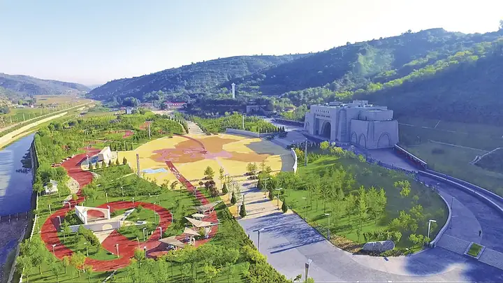
Photo adjustments
EXIF orientation normalized; resized without changing aspect ratio; converted to WebP. No subject edits.
- Administrative area
- County · 县
- Part of
- Qingyang
- Chinese name
- 华池县
- Local areas
- County guide
Area & population
- Area in the source
- 3,791.00 km²
- Population · 2018
- 138,680
- Administrative seat
- Rouyuan
Source: cited geographic source, as of the dates shown.
Setting and landscape
Huachi borders Zhidan (志丹), Wuqi (吴起) and Dingbian (定边) in Shaanxi to the north-east, and Qingcheng (庆城), Huan County (环县) and Heshui (合水) in Gansu to the south-west. Its ground is a mix of loess ridges, deep gullies, valleys and tablelands between about 1,100 and 1,780 m, with 380 to 510 mm of rain a year. Part of the natural secondary forest of the Ziwu Ridge (子午岭) lies in the county, which the county government puts at 32.7 per cent of the whole Ziwu Ridge forest.
History
A Huachi County was first set up under the Western Wei, with its seat at today's Donghuachi (东华池); it took its name from Huachi Water, the old name of the Erjiangchuan River (二将川). The county was abolished and restored several times: re-established in 602, abolished in 617, restored in 621 and merged into Heshui in 1071. The Warring States Qin wall crosses the north of the county and the Qin Straight Road (秦直道) runs through the east, and old forts such as Luotuo (骆驼城), Kuduohan (库多汗城) and Dashun (大顺城) are scattered across it. The Northern Song statesman Fan Zhongyan (范仲淹) served on this frontier.
In 1934 Liu Zhidan (刘志丹), Xie Zichang (谢子长) and Xi Zhongxun (习仲勋) founded the Shaanxi–Gansu Border Soviet government at Nanliang, and Huachi County was re-created the same year.
What to see
The county counts 39 revolutionary sites, including the former seat of the Shaanxi–Gansu Border Soviet government and the former homes of Liu Zhidan, Xi Zhongxun and Ma Xiwu (马锡五). The Nanliang Revolutionary Memorial Hall (南梁革命纪念馆) is a national 4A scenic area and a national patriotic-education base; a separate exhibition hall covers the Ma Xiwu method of holding trials. Older remains include the Jin-dynasty twin stone pagodas carved with images (金代双石造像塔), and a scented sachet described as a thousand years old was found at Shuangta Temple (双塔寺).
Food and local products
Qiaochuan buckwheat chopped noodles (乔川荞剁面) come from Qiaochuan (乔川乡), Yuancheng (元城镇) and Baima (白马乡) in the county. Rested buckwheat dough is chopped into even strands with a special two-handled knife, and the noodles are eaten in meat or vegetable broth or dressed dry; the same flour makes buckwheat wowo (荞面窝窝). In 2024 Qiaochuan buckwheat was certified as a grade-A green food. The county calls itself the home of white melon seeds and also grows daylilies, black wood-ear fungus and minor grains. Paper-cuts, scented sachets, embroidery and cloth appliqué pictures are the local crafts.
Highlights
- Nanliang Revolutionary Memorial Hall 南梁革命纪念馆: National 4A scenic area and national patriotic-education base devoted to the Nanliang revolutionary base.
- Qiaochuan buckwheat chopped noodles 乔川荞剁面: Buckwheat dough chopped into strands with a two-handled knife, served in broth or dry.
- Jin-dynasty twin stone pagodas 金代双石造像塔: Finely carved pair of stone image pagodas from the Jin dynasty.
- Ziwu Ridge forest 子午岭: Huachi holds 32.7 per cent of the Ziwu Ridge natural secondary forest.
Sources for this guide
魅力华池_华池县人民政府 · Huachi County People's Government
【高天厚土・福地庆阳 】 华池篇丨一碗荞剁面 一味华池魂 · Huachi County People's Government
华池县 - 维基百科,自由的百科全书 · Wikipedia (Chinese) · CC BY-SA 4.0
Original English written from the listed sources and checked sentence by sentence against quoted extracts by a separate reviewer. Updated 2026-09-23.
Explore Huachi County
Core places to explore, with English and Chinese names.
Places to explore around Huachi County
 AI illustration · AI
 Plan your visit
Getting there
Huachi County is about 90 km in a straight line from central Qingyang. Search for 华池县 in a map app to find stations and your accommodation.
Where to stay →Build your route
Start with Nanliang Revolutionary Memorial Hall. The linked place guides have entrance and visit details.
Continue with Qingyang →More in Qingyang
Sources & geographic information
Administrative names and parent areas: Official geographic directory · Reference date 2026-09-06.
Some facts checked against 华池县 — Wikipedia contributors, CC BY-SA 4.0.
Map data © OpenStreetMap contributors. Pins mark approximate centres, not entrances or boundaries.