


Get to know Congtai District

Photo adjustments
Full frame retained; proportionally resized and converted to WebP. No retouching or changes to the photographed subject. Card displays may crop the view.
- Administrative area
- District · 市辖区
- Part of
- Handan
- Chinese name
- 丛台区
- Local areas
- District guide
Area & population
- Area in the source
- 28.00 km²
- Population · 2020 census
- 572,175
- Administrative seat
- East Lianfang Subdistrict
Source: cited geographic source, as of the dates shown.
What to see
Congtai Park (丛台公园), on the west side of Zhonghua Street (中华大街), was laid out around the Wuling Congtai; the park was rated a 4A scenic area in 2007. Tradition holds that King Wuling of Zhao (赵武灵王, reigned 325–299 BC) built the terrace to watch dancing and military drills; the name refers to many platforms joined together. The present three-tier, 26-metre structure dates from the Tongzhi reign (1862–1874) of the Qing, and Hebei listed it as a provincial protected site in 1982. Li Bai, Du Fu and Bai Juyi all climbed it.
North of the terrace stands the Shrine of the Seven Worthies (七贤祠), honouring three loyal ministers of Jin and four Zhao figures including Lian Po (廉颇) and Lin Xiangru (蔺相如). West of the shrine is a stele forest of 44 inscribed stones. On an island in Congtai Lake (丛台湖), the Wangzhu Pavilion (望诸榭) was first built in the Yongzheng reign to honour the general Yue Yi (乐毅).
The Handan Museum (邯郸市博物馆), at 399 Renmin East Road (人民东路), occupies an exhibition hall completed in December 1968. Its galleries cover the Cishan culture (磁山文化), Zhao culture, the Eastern Wei tomb of Princess Ruru (茹茹公主) and Cizhou ware; Wikipedia describes the 1,000-square-metre Cizhou gallery, with a rebuilt kiln, as the largest display of the ware in China.
In Huangliangmeng town, the Lüxian Shrine (吕仙祠) honours the immortal Lü Dongbin (吕洞宾) on the spot where the Yellow Millet Dream (黄粱梦) story is said to have happened. Founded in the Northern Song and much enlarged under the Qing Jiaqing emperor, it has halls to Zhongli Quan (汉钟离) and Lü Dongbin and a hall with murals of the story and a reclining figure of its dreamer, Lu Sheng (卢生). It became a national key protected site in 2013.
Getting oriented
Congtai was created in October 1980, when urban Handan was split into three districts. It borders Fuxing District (复兴区) to the west, Wu'an (武安市) to the north-west and Yongnian District (永年区) to the north, while Heping Road (和平路) marks its southern boundary with Hanshan District (邯山区). In 2016 the townships of Nanlügu (南吕固), Jianzhuang (兼庄) and Sanling (三陵) were moved into the district from Handan County (邯郸县).
Highlights
- Wuling Congtai 武灵丛台: Three-tier, 26-metre terrace in Congtai Park, rebuilt in the Tongzhi reign; Hebei provincial protected site since 1982.
- Congtai Park 丛台公园: Park around the terrace with the Seven Worthies Shrine, a stele forest and Congtai Lake; 4A scenic area since 2007.
- Handan Museum 邯郸市博物馆: City museum in a 1968 exhibition hall, with galleries on Cishan culture, Zhao culture, Princess Ruru's tomb and Cizhou ware.
- Lüxian Shrine 吕仙祠: Temple to Lü Dongbin at Huangliangmeng, tied to the Yellow Millet Dream story; national key protected site since 2013.
Sources for this guide
丛台概况-邯郸市丛台区人民政府 · Congtai District People's Government, Handan
丛台区 - 维基百科 · Wikipedia (Chinese) · CC BY-SA 4.0
武灵丛台 - 维基百科 · Wikipedia (Chinese) · CC BY-SA 4.0
丛台公园 - 维基百科 · Wikipedia (Chinese) · CC BY-SA 4.0
吕仙祠 - 维基百科 · Wikipedia (Chinese) · CC BY-SA 4.0
邯郸市博物馆 - 维基百科 · Wikipedia (Chinese) · CC BY-SA 4.0
Original English written from the listed sources and checked sentence by sentence against quoted extracts by a separate reviewer. Updated 2026-09-24.
Explore Congtai District
Core places to explore, with English and Chinese names.
Places to explore around Congtai District
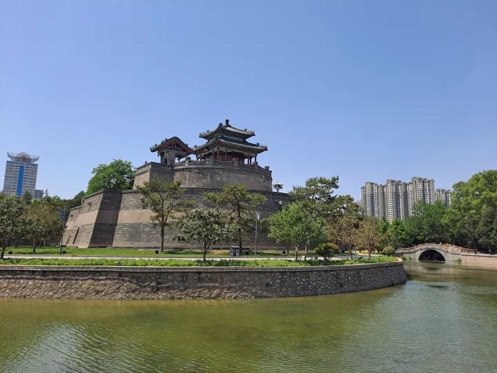 The Wuling Congtai terrace and pavilion within Congtai Park, Handan · 邯郸丛台公园内的武灵丛台 Source-recorded photograph date: 2025-05-06 13:23:58.
Congtai Park丛台公园
Handan's historic park built around Wuling Congtai, a Zhao-era terrace rebuilt under the Qing, with a lake pavilion, shrine and stele forest.
Read the place guide → The contemporary Handan Museum building · 邯郸市博物馆现馆建筑 Source-recorded photograph date: 2025-05-06 11:44:09.
Handan Museum邯郸市博物馆
Handan Museum connects the city's early history with two distinctive regional traditions: Cizhou ceramics and stone carving. Its historical survey supplies the setting for Handan's changing role, while the specialist galleries…
Read the place guide →Plan your visit
Getting there
Congtai District is about 4 km in a straight line from central Handan. Search for 丛台区 in a map app to find stations and your accommodation.
Where to stay →Build your route
Congtai Park and Handan Museum are both listed here. The linked place guides have entrance and visit details.
Continue with Handan →More in Handan
Sources & geographic information
Administrative names and parent areas: Official geographic directory · Reference date 2026-09-06.
Some facts checked against 丛台区 — Wikipedia contributors, CC BY-SA 4.0.
Some facts checked against 武灵丛台 — Wikipedia contributors, CC BY-SA 4.0.
Some facts checked against 丛台公园 — Wikipedia contributors, CC BY-SA 4.0.
Some facts checked against 吕仙祠 — Wikipedia contributors, CC BY-SA 4.0.
Some facts checked against 邯郸市博物馆 — Wikipedia contributors, CC BY-SA 4.0.
Photo: Congtai Park · H2v5o68z · CC0. Full frame retained; proportionally resized and converted to WebP. No retouching or changes to the photographed subject. Card displays may crop the view.

Photo: Handan Museum · H2v5o68z · CC0. Full-frame source proportionally resized and converted to WebP for display. No subject alteration. Source-supplied marks and edits remain; cards may crop the view.

Map data © OpenStreetMap contributors. Pins mark approximate centres, not entrances or boundaries.