

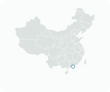
Get to know Patane e São Paulo
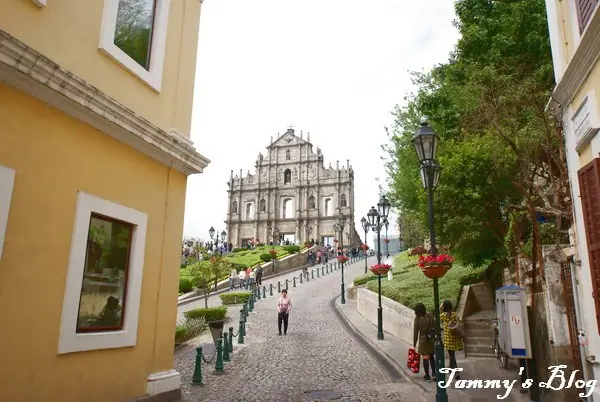
Photo adjustments
EXIF orientation normalized; resized without changing aspect ratio; converted to WebP. No subject edits.
- Administrative area
- Statistical area · 統計分區
- Part of
- Macau
- Chinese name
- 沙梨頭及大三巴區
- Local areas
- Statistical area guide
Patane: the old village
Patane was a Chinese village before it was a city district. A memorial by the Qing official Qiying (耆英) recorded that its villagers had kept their ancestral land for more than three hundred years without paying rent to the Portuguese, and the village name first appears in writing on a Macau map in the Guangdong Gazetteer (廣東通志) compiled in the ninth year of the Yongzheng reign. The Chinese name first referred to the hill where Camões Garden (白鴿巢公園) now stands, because the hill or the rocks on its shore looked like sand pears; the Portuguese name may come from Pattani (北大年) in Siam. The Portuguese built a fort on a slope near Patane in 1624, and the Ming government ordered it pulled down in 1640. In 1863 the Portuguese authorities took over Patane, outside the city wall, and began filling in the beach to create the Patane waterfront street.
What to see
The Ruins of St. Paul's are the granite front of the Church of Mater Dei, built between 1602 and 1640, together with the remains of the adjoining St. Paul's College; both were destroyed by fire in 1835. The front is 23 metres wide and 25.5 metres high in five levels, and its carvings combine biblical images with Chinese characters, chrysanthemums, a Portuguese ship and Chinese lions. Sixty-eight stone steps lead up to it, and in 2005 it became part of the Historic Centre of Macao on the UNESCO World Heritage list. Macao's heritage authority describes the college as the first western-style university in the Far East.
Close by stand Na Tcha Temple (大三巴哪吒廟), a single-room temple built in 1888, and a surviving section of the Old City Walls on Calçada de S. Francisco Xavier, dating from as early as 1569 and made of chunambo, a layered mix of clay, soil, sand, rice straw, crushed rock and oyster shells. Mount Fortress (大炮台), built with the Jesuits between 1617 and 1626, overlooks the ruins; with the church and college it formed what the heritage authority calls Macao's acropolis.
In Patane, the Patane Earth God Temple (沙梨頭土地廟) has four halls set in a row against the hill, facing the sea, for Lishan Shengmu (梨山聖母) and the Vanguard god, the Earth God, Guanyin and the physician Hua Tuo (華佗). A stone tablet on a side wall is dated 1789, and the temple was restored in 1924, 1998 and 2014.
Highlights
- Ruins of St. Paul's 大三巴牌坊: Front of the Church of Mater Dei (1602–1640), destroyed by fire in 1835; part of the Historic Centre of Macao since 2005.
- Na Tcha Temple 大三巴哪吒廟: Small single-chamber temple built in 1888 beside the Ruins of St. Paul's.
- Patane Earth God Temple 沙梨頭土地廟: Four halls in a row facing the sea, with a stone tablet dated 1789.
Sources for this guide
Ruins of St. Paul’s College (Former Mater Dei Church, forecourt and staircase) · Cultural Affairs Bureau of the Macao SAR (Macao World Heritage site)
Na Tcha Temple (next to the Ruins of St. Paul’s College) · Cultural Affairs Bureau of the Macao SAR (Macao World Heritage site)
Old City Walls (Section at Calçada de S. Francisco Xavier) · Cultural Affairs Bureau of the Macao SAR (Macao World Heritage site)
沙梨头 - 维基百科,自由的百科全书 · Wikipedia (Chinese) · CC BY-SA 4.0
Ruins of Saint Paul's - Wikipedia · Wikipedia (English) · CC BY-SA 4.0
沙梨头土地庙 - 维基百科,自由的百科全书 · Wikipedia (Chinese) · CC BY-SA 4.0
Mount Fortress · Cultural Affairs Bureau of the Macao SAR (Macao World Heritage site)
Original English written from the listed sources and checked sentence by sentence against quoted extracts by a separate reviewer. Updated 2026-09-23.
Find Patane e São Paulo
A reliable area-level map point is not available in the current sources.
Plan your visit
Getting there
Search for 沙梨頭及大三巴區 in a map app to find stations and your accommodation.
Where to stay →More in Macau
Sources & geographic information
Administrative names and parent areas: Official geographic directory · Reference date 2026-09-06.
DSEC statistical-zone directory
MGTO: Ruins of St. Paul’s College
MGTO: Strolling Through the Historic Centre of Macao
Some facts checked against 沙梨头 — Wikipedia contributors, CC BY-SA 4.0.
Some facts checked against Ruins of Saint Paul's — Wikipedia contributors, CC BY-SA 4.0.
Some facts checked against 沙梨头土地庙 — Wikipedia contributors, CC BY-SA 4.0.
Map data © OpenStreetMap contributors. Pins mark approximate centres, not entrances or boundaries.