


Get to know Zhangping
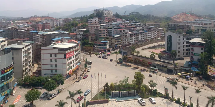
Photo adjustments
Full frame retained; proportionally resized and converted to WebP. No retouching or changes to the photographed subject. Card displays may crop the view.
- Administrative area
- County-level city · 县级市
- Part of
- Longyan
- Chinese name
- 漳平市
- Local areas
- County-level city guide
Area & population
- Area in the source
- 2,956.00 km²
- Population · 2020
- 253,394
Source: cited geographic source, as of the dates shown.
Setting and landscape
Three ranges meet here: the Daiyun (戴云山), Daimao (玳瑁山) and Boping (博平岭) mountains. The Jiulong North River cuts across the middle of the city and splits it into northern and southern halves, with gentler valley land and hills along both banks. South of the river the Boping range dominates, and the Xiazhe stream (下浙溪) forms the Yongfu basin (永福山间盆地) at around 750 metres. The highest peak is Kusunlinjian (苦笋林尖) at 1,666 metres. Yong'an (永安市) and Datian (大田县) lie to the north, Yongchun (永春县) and Anxi (安溪县) to the east, Hua'an (华安县) and Nanjing (南靖县) to the south, and Xinluo District (新罗区) to the west.
History
Zhangping County was carved out of Longyan County in 1470, the sixth year of the Ming Chenghua reign, and became a city in August 1990. Ningyang County (宁洋县) was abolished in 1956 and its seat at Shuangyang (双洋) passed to Zhangping. The local speech is the Zhangping dialect of Southern Min (闽南语).
What to see
Yongfu Town (永福镇) in the south-west is called "Mainland Alishan" (大陆阿里山) by Taiwanese investors because its climate matches Taiwan's Alishan tea districts. The scenic area there is a national 3A site with an average altitude of 780 metres, and in 2008 the town became one of eight national Taiwanese farmers' business parks. At the Taipin cherry tea garden (台品樱花茶园) cherry trees flower among the tea from January to March, and the Yongfu cherry garden (永福樱花园) grows varieties including Taiwan cherry and Somei-Yoshino.
In Donghu village (东湖村), in central Xinan Town (溪南镇), the Zhang lineage founded its ancestral hall, the Renyi Hall (仁怡堂), in the late Ming. More than 30 old houses followed, some keeping Qing-dynasty murals and carvings, and the village is known for handmade Donghu rice noodles (东湖米粉). Other sights include the late Palaeolithic site at Qihe Cave (奇和洞) and the Longjin waterfall (龙津瀑布).
Food and local products
Zhangping Shuixian tea (漳平水仙茶) is pressed into square cakes: fresh leaves are sun-withered, tossed, pan-fired and rolled, pressed in wooden moulds, wrapped in soft paper and charcoal-roasted. The liquor is golden and clear with an osmanthus-like fragrance. The collective trademark holds a national agricultural geographical indication. Other local products include dried bamboo shoots, Ming ginger (明姜), Luzhi pomelo (芦芝柚) and bamboo and rattan weaving.
Getting oriented
Zhangping station serves the Yingtan–Xiamen, Zhangping–Longyan and Zhangping–Quanzhou–Xiaocuo railways, and Zhangping West station is on the Nanping–Longyan line. The Shuangyong expressway passes through.
Highlights
- Mainland Alishan scenic area, Yongfu 大陆阿里山景区: National 3A scenic area at 780 metres, with high-mountain tea gardens and cherry blossom from January to March.
- Donghu old village 东湖古村落: Village of the Zhang lineage, whose ancestral hall dates from the late Ming, with more than 30 old houses and Qing murals.
- Zhangping Shuixian tea cakes 漳平水仙茶饼: Shuixian tea pressed into square cakes in wooden moulds and charcoal-roasted.
- Kusunlinjian 苦笋林尖: Highest peak in the city at 1,666 metres.
Sources for this guide
漳平概况-龙岩市漳平市人民政府 · Zhangping Municipal People's Government
地理环境-龙岩市漳平市人民政府 · Zhangping Municipal People's Government
水仙茶-龙岩市漳平市人民政府 · Zhangping Municipal People's Government
大陆阿里山景区-龙岩市漳平市人民政府 · Zhangping Municipal People's Government (Culture and Tourism Bureau)
东湖古村落-龙岩市漳平市人民政府 · Zhangping Municipal People's Government (Culture and Tourism Bureau)
漳平市 - 维基百科,自由的百科全书 · Wikipedia (Chinese) · CC BY-SA 4.0
Original English written from the listed sources and checked sentence by sentence against quoted extracts by a separate reviewer. Updated 2026-09-23.
Explore Zhangping
Core places to explore, with English and Chinese names.
Places to explore around Zhangping
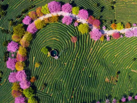 Yongfu Tea Gardens ·
 Plan your visit
Getting there
Zhangping is about 45 km in a straight line from central Longyan. Search for 漳平市 in a map app to find stations and your accommodation.
Where to stay →Build your route
Start with Yongfu Tea Gardens. The linked place guides have entrance and visit details.
Continue with Longyan →More in Longyan
Sources & geographic information
Administrative names and parent areas: Official geographic directory · Reference date 2026-09-06.
Some facts checked against 漳平市 — Wikipedia contributors, CC BY-SA 4.0.
Photo: Yongfu Tea Gardens · Source photographer · License not provided. EXIF orientation normalized; resized without changing aspect ratio; converted to WebP. No subject edits.
Map data © OpenStreetMap contributors. Pins mark approximate centres, not entrances or boundaries.