


Get to know Liancheng County
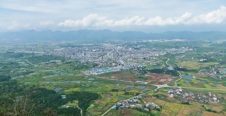
Photo adjustments
Full frame retained; proportionally resized and converted to WebP. No retouching or changes to the photographed subject. Card displays may crop the view.
- Administrative area
- County · 县
- Part of
- Longyan
- Chinese name
- 连城县
- Local areas
- County guide
Area & population
- Area in the source
- 2,582.00 km²
- Population · 2020
- 250,518
Source: cited geographic source, as of the dates shown.
Setting and landscape
The county lies on the eastern side of the southern Wuyi Mountains (武夷山). A chain of river basins runs north to south through the centre-west, where the county town stands. About two-thirds of the land, in the east and south-east, belongs to the Meihua Mountain (梅花山) highlands of the Daimao range (玳瑁山脉), and Jiangjun Mountain (将军山) in Quxi (曲溪) feeds streams that end up in the Min (闽江), Ting (汀江) and Jiulong (九龙江) rivers. Songmao Ridge (松毛岭) in the west forms the boundary with Changting (长汀). The county lists eight hot springs, including those at Xinquan (新泉).
History
Once part of Changting, the area had a Tang-dynasty fort called Liancheng (莲城堡, 'lotus fort'), which gave its name to the county created in 1133. In 1346, after rebels were put down, the grass radical was dropped from the first character of the name, changing "莲" (lotus) to "连" (to join). Under the Ming and Qing it was one of the eight Hakka counties of Tingzhou prefecture (汀州府). Mao Zedong (毛泽东) led the Red Fourth Army into Liancheng three times in 1929, and the county was the main battlefield of the Songmaoling battle, the Central Red Army's last fight on its eastern front before the Long March.
What to see
Guanzhai Mountain (冠豸山) rises 1.5 kilometres east of the county town; it takes its name from a boulder shaped like the head of the mythical xiezhi (獬豸), and its main peak, Wulao (五老峰), reaches 661 metres. It became a national key scenic area in 1994 and was named in the fifth group of national geoparks in 2009; Shimen Lake (石门湖) is one of its nine touring areas. Peitian (培田) in Xuanhe (宣和) is a national historic and cultural village whose old buildings are a national key protected site. Sibao (四堡) was one of the four great woodblock-printing centres of the Ming and Qing, and its old printing houses are also nationally protected. The Yunlong Bridge (云龙桥), a covered bridge, hosts the Luofang 'walking stories' parade (罗坊走古事), listed as national intangible heritage along with Liancheng's woodblock printing.
Food and local products
The Liancheng white duck (连城白鸭), with white feathers, a black bill and black feet, is a protected local breed and a geographical-indication product; the county's best-known dish is the duck steamed over water (隔水清蒸). Red-heart dried sweet potato (红心地瓜干) is one of the eight dried foods of western Fujian and also holds geographical-indication status.
Highlights
- Mount Guanzhai 冠豸山: National key scenic area since 1994, 1.5 km east of the county town.
- Peitian Ancient Village 培田古民居: Historic village in Xuanhe whose old buildings are a national key protected site.
- Sibao woodblock printing 四堡: One of four Ming-Qing printing centres; the printing technique is national intangible heritage.
- Liancheng white duck 连城白鸭: White-feathered, black-billed local breed; its best-known dish is the duck steamed over water.
Sources for this guide
连城概况 · Liancheng County People's Government, Longyan
自然地理 · Liancheng County People's Government, Longyan
连城县 - 维基百科 · Wikipedia (Chinese) · CC BY-SA 4.0
冠豸山 - 维基百科 · Wikipedia (Chinese) · CC BY-SA 4.0
Original English written from the listed sources and checked sentence by sentence against quoted extracts by a separate reviewer. Updated 2026-09-23.
Explore Liancheng County
Core places to explore, with English and Chinese names.
Places to explore around Liancheng County
 Layered peaks of Mount Guanzhai seen within the scenic area, Liancheng County, Longyan · 龙岩连城冠豸山山峰景观 Source-recorded photograph date: 24 January 2011 (original upload date).
Mount Guanzhai冠豸山
Mount Guanzhai rises immediately east of Liancheng county town in Longyan. Rock pillars and steep isolated formations define its scenery.
Read the place guide → Peitian Ancient Dwellings · 培田古民居
Peitian Ancient Dwellings培田古民居
Peitian (培田古民居) is a Hakka village in Xuanhe township, in the west of Liancheng county, Longyan, Fujian, whose Ming and Qing houses, ancestral halls and academies survive as a single dense group along a kilometre-long street.
Read the place guide →Plan your visit
Getting there
Liancheng County is about 60 km in a straight line from central Longyan. Search for 连城县 in a map app to find stations and your accommodation.
Where to stay →Build your route
Mount Guanzhai and Peitian Ancient Dwellings are both listed here. The linked place guides have entrance and visit details.
Continue with Longyan →More in Longyan
Sources & geographic information
Administrative names and parent areas: Official geographic directory · Reference date 2026-09-06.
Some facts checked against 连城县 — Wikipedia contributors, CC BY-SA 4.0.
Some facts checked against 冠豸山 — Wikipedia contributors, CC BY-SA 4.0.
Photo: Mount Guanzhai · rheins · CC BY 3.0. Full frame retained; proportionally resized and converted to WebP. No retouching or changes to the photographed subject. Card displays may crop the view.

Photo: Peitian Ancient Dwellings · Source photographer · License not provided. EXIF orientation normalized; resized without changing aspect ratio; converted to WebP. No subject edits.
Map data © OpenStreetMap contributors. Pins mark approximate centres, not entrances or boundaries.