


Get to know Jimei District
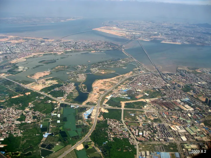
Photo adjustments
Full frame retained; proportionally resized and converted to WebP. No retouching or changes to the photographed subject. Card displays may crop the view.
- Administrative area
- District · 市辖区
- Part of
- Xiamen
- Chinese name
- 集美区
- Local areas
- District guide
Area & population
- Population · 2020 census
- 1,036,987
Source: cited geographic source, as of the dates shown.
Setting and history
The district borders Changtai District (长泰区) of Zhangzhou to the north-west, Tong'an District (同安区) to the north-east and Haicang District (海沧区) to the south-west, and is known geographically as the Jimei Peninsula. Its old name, Xunwei (浔尾), meant the tail of the Xun River (浔江); it was refined to Jimei in the Ming dynasty.
For most of its history Jimei belonged to Tong'an County (同安县). In 1390 a Ming garrison post, the Gaopu battalion (高浦守御千户所), was set up at today's Gaopu community. Local people began emigrating overseas in the late Yuan and early Ming, and Tan Kah Kee, born here in 1874, returned home to found the Jimei School (集美学校) in 1913.
What to see
Jimei School Village (集美学村) grew from that school into a campus with a kindergarten, hospital and library, built in the East-meets-West Jiageng style (嘉庚建筑) that Tan planned himself. In 2006 it was listed, together with the early buildings of Xiamen University, as a national key cultural relics protection unit.
In Ao Garden (鳌园), south of the Jimei Liberation Monument (集美解放纪念碑) inscribed by Mao Zedong, lies Tan Kah Kee's tomb. Begun in 1955 and used for his burial in 1961, it faces south, has a turtle-shaped mound and is backed by a horseshoe wall set with reliefs of his life; it became a national key cultural relics protection unit in 1988. The district lists the Tan Kah Kee memorial area (陈嘉庚纪念胜地) as a national 4A scenic area.
The Xiamen Garden Expo Park (厦门园林博览苑) in Xinglin Bay (杏林湾) hosted the 6th China (Xiamen) International Garden and Flower Expo in 2007. Channels were cut to make nine islands joined by 16 bridges, over 10.82 km² of land and water.
Getting oriented
Xiamen North Railway Station (厦门北站) is in Jimei, and the Yingtan–Xiamen, Fuzhou–Xiamen, Longyan–Xiamen and Xiamen–Shenzhen lines and the Fuzhou–Xiamen high-speed railway pass through. Three sea bridges and a seawall link the district to Xiamen Island. A 23 km² education zone planned in 2003 around the old school village now holds Jimei University, Huaqiao University and Xiamen University of Technology among 16 universities and research institutes.
Highlights
- Jimei School Village 集美学村: Campus founded by Tan Kah Kee in 1913, national key cultural relics protection unit since 2006.
- Tan Kah Kee's tomb in Ao Garden 鳌园陈嘉庚墓: Turtle-shaped tomb begun in 1955, national key cultural relics protection unit since 1988.
- Xiamen Garden Expo Park 厦门园林博览苑: Nine islands joined by 16 bridges in Xinglin Bay, built for the 2007 garden expo.
Sources for this guide
区情概况 · 厦门市集美区人民政府
集美区 - 维基百科,自由的百科全书 · Wikipedia · CC BY-SA 4.0
集美学村 - 维基百科,自由的百科全书 · Wikipedia · CC BY-SA 4.0
陈嘉庚墓 - 维基百科,自由的百科全书 · Wikipedia · CC BY-SA 4.0
厦门园林博览苑 - 维基百科,自由的百科全书 · Wikipedia · CC BY-SA 4.0
Original English written from the listed sources and checked sentence by sentence against quoted extracts by a separate reviewer. Updated 2026-09-23.
Explore Jimei District
Core places to explore, with English and Chinese names.
Places to explore around Jimei District
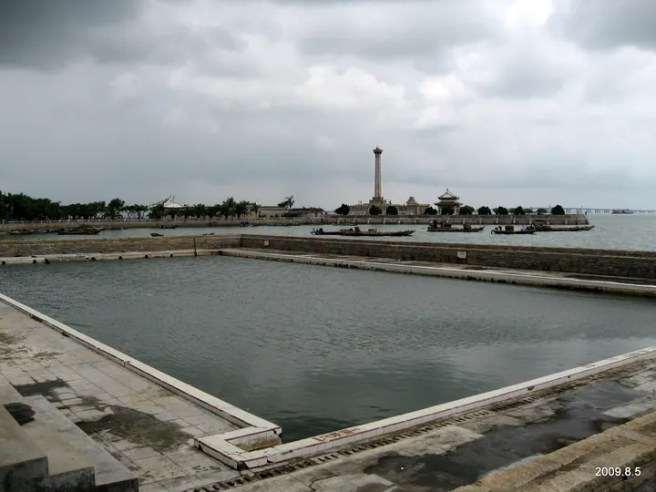 A view across water toward 鳌园: a large rectangular stone-edged water basin with steps in the foreground, a stone causeway with moored boats beyond it, the tall column of the 集美解放纪念碑 with a pavilion beside it on the far shore, trees and a distant bridge under heavy grey cloud.
Jimei School Village and Aoyuan Garden集美学村与鳌园
Jimei School Village brings together the schools established by Tan Kah Kee, while Aoyuan is the seafront memorial garden containing his tomb.
Read the place guide → The main entrance plaza arch of Xiamen Garden Expo Park, Jimei District, Xiamen. · 厦门市集美区厦门园林博览苑主入口广场牌楼。 Source-recorded photograph date: Taken on 5 August 2009.
Xiamen Garden Expo Park厦门园林博览苑
Island park in Xinglin Bay, Jimei, Xiamen, built for the 2007 garden expo, with bridges, the Moonlight Ring and wintering cormorants.
Read the place guide →Plan your visit
Getting there
Jimei District is about 20 km in a straight line from central Xiamen. Search for 集美区 in a map app to find stations and your accommodation.
Where to stay →Build your route
Jimei School Village and Aoyuan Garden and Xiamen Garden Expo Park are both listed here. The linked place guides have entrance and visit details.
Continue with Xiamen →More in Xiamen
Sources & geographic information
Administrative names and parent areas: Official geographic directory · Reference date 2026-09-06.
Some facts checked against 集美区 — Wikipedia contributors, CC BY-SA 4.0.
Some facts checked against 集美学村 — Wikipedia contributors, CC BY-SA 4.0.
Some facts checked against 陈嘉庚墓 — Wikipedia contributors, CC BY-SA 4.0.
Some facts checked against 厦门园林博览苑 — Wikipedia contributors, CC BY-SA 4.0.
Photo: Jimei School Village and Aoyuan Garden · Tiger@西北 · CC BY-SA 3.0. Full frame retained; proportionally resized and converted to WebP. No retouching or changes to the photographed subject. Card displays may crop the view.

Photo: Xiamen Garden Expo Park · Tiger@西北 · CC BY-SA 3.0. Full frame retained; proportionally resized and converted to WebP. No retouching or changes to the photographed subject. Card displays may crop the view.

Map data © OpenStreetMap contributors. Pins mark approximate centres, not entrances or boundaries.