


Get to know Jinchengjiang District
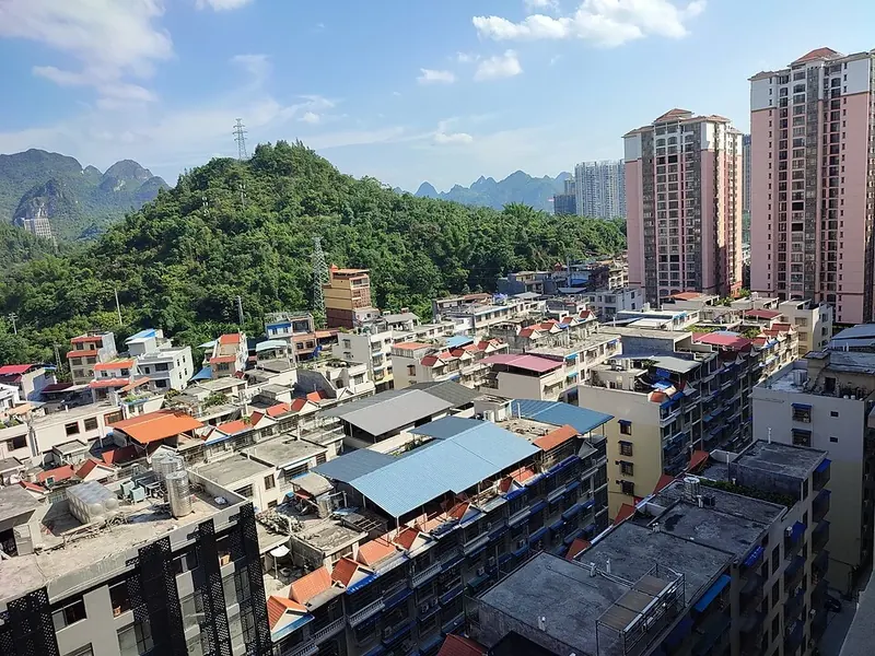
Photo adjustments
Full frame retained; proportionally resized and converted to WebP. No retouching or changes to the photographed subject. Card displays may crop the view.
- Administrative area
- District · 市辖区
- Part of
- Hechi
- Chinese name
- 金城江区
- Local areas
- District guide
Area & population
- Area in the source
- 2,340.00 km²
- Population · 2020 census
- 372,521
- Administrative seat
- Jinchengjiang Subdistrict
Source: cited geographic source, as of the dates shown.
Setting and landscape
The ground tilts from northwest to southeast, mostly between 400 and 600 m above sea level and rising to 1,114 m. The district borders Yizhou District (宜州区) to the east, Donglan County (东兰县) to the west, Du'an (都安) to the south, and Nandan (南丹) and Huanjiang (环江) to the north. The climate is transitional between the mid- and southern subtropics. Its 32 rivers include the Long River (龙江), which rises in Libo County (荔波县) in Guizhou, the Diao River (刁江) and the Huanjiang. The district government calls the area a home of non-ferrous metals, with lead, zinc, antimony and tin among the proven ores.
History
Hechi County (河池县) was set up here early in the Song dynasty. In 1107 the area became Tingzhou (庭州) and the county was renamed Huaide (怀德县), before both reverted in 1110. In 1504 the Ming raised it to Hechi department (河池州); it became a county again in January 1912 and came under Communist control on 26 November 1949. The county became a county-level city in 1983, and in 2002 that city became Jinchengjiang District of the new prefecture-level Hechi.
The Seventh and Eighth Red Armies (红七军、红八军) were stationed here three times. The Hechi Red Army Slogan Building (河池红军标语楼) keeps more than 50 slogans and is a national protected site, and the district government describes the site of the two armies' reorganisation and review at Hechi as the place of Deng Xiaoping's first military review.
What to see
Landscapes named by the district government include the Liujia Little Three Gorges (六甲小三峡), Liushui Rock (流水岩), Zhenzhu Rock (珍珠岩) and Zhuangwang Lake (壮王湖). Historic remains include the cliff carvings at Luohan Rock (罗汉岩摩崖造像), the steles of the Hechi Confucian Temple (河池文庙碑刻), the Pingman stele at Baitu (白土“平蛮”碑) and a Qing-dynasty stone-arch bridge.
Festivals include the Zhuang Sanyuesan song festival (三月三), the Yao Danu festival (达努节), the Miao Caihuashan (踩花山) and a shoulder-pole culture festival at Xialuo in Baoping (保平下洛). Mo Yi Dawang (莫一大王), a legendary Zhuang hero, is known to every household.
Getting oriented
The Guizhou–Guangxi railway crosses the district and stops at Jinchengjiang Station; the Guiyang–Nanning passenger line serves Hechi West Station (河池西站). The district government puts Liuzhou 197 km to the east, Guiyang 421 km to the west and Nanning 270 km away, and Hechi's civil airport 30 km from the urban area. The Hechi city government now sits in Yizhou District.
Highlights
- Hechi Red Army Slogan Building 河池红军标语楼: More than 50 Red Army slogans; national protected site.
- Luohan Rock cliff carvings 罗汉岩摩崖造像: Cliff carvings listed among the district's historic sights.
- Liujia Little Three Gorges 六甲小三峡: River landscape named among the district's natural sights.
Sources for this guide
金城江区概况 · Jinchengjiang District People's Government, Hechi
历史人文和民族特色 · Jinchengjiang District People's Government, Hechi
地理综述 · Jinchengjiang District People's Government, Hechi
金城江概况(历史沿革) · Jinchengjiang District People's Government, Hechi
金城江区 · Wikipedia (Chinese) · CC BY-SA 4.0
Original English written from the listed sources and checked sentence by sentence against quoted extracts by a separate reviewer. Updated 2026-09-24.
Explore Jinchengjiang District
Core places to explore, with English and Chinese names.
Jinchengjiang District 金城江区
Plan your visit
Getting there
Jinchengjiang District is about 5 km in a straight line from central Hechi. Search for 金城江区 in a map app to find stations and your accommodation.
Where to stay →More in Hechi
Sources & geographic information
Administrative names and parent areas: Official geographic directory · Reference date 2026-09-06.
Some facts checked against 金城江区 — Wikipedia contributors, CC BY-SA 4.0.
Map data © OpenStreetMap contributors. Pins mark approximate centres, not entrances or boundaries.