


Get to know Nandan County

- Administrative area
- County · 县
- Part of
- Hechi
- Chinese name
- 南丹县
- Local areas
- County guide
Area & population
- Area in the source
- 3,902.00 km²
- Population · 2020
- 275,554
- Administrative seat
- Chengguan (城关镇)
Source: cited geographic source, as of the dates shown.
Setting and landscape
The county is long and narrow, 72 km across and 106 km from north to south, with ground falling from northwest to southeast and most of it between 500 and 1,000 m. The mean annual temperature is 17.4°C. Rivers include the Hongshui (红水河), the Laping (拉平河), the Dagou (打狗河) and the Qingshui (清水河), and there are ten underground rivers. The county is called "China's home of non-ferrous metals" and the "tin capital" (锡都), and the county government says its tin reserves are the largest in China.
History
The northwest, around Yueli (月里), Liuzhai (六寨) and Lihu (里湖), once belonged to the ancient Yelang (夜郎) kingdom. In 974 the Zhuang chief Mo Hongyan (莫洪燕) submitted to the Song and Nandan Prefecture was created; it was briefly renamed Guanzhou (观州) between 1107 and 1134. Later Mo chiefs submitted to the Yuan in 1278 and to the Ming in 1368; rule by native chiefs ended in 1905, when regular officials took over. Nandan became a county in 1918 and came under Communist control on 14 January 1950.
What to see
Geyasigu (歌娅思谷), a 4A folk-custom park in Lihu Yao Township (里湖瑶族乡), is built around Baiku Yao (白裤瑶) villages, fields, a river and an underground-river cave, with Baiku Yao costume-making on show and long-table feasts. The Lihu Baiku Yao Eco-museum (里湖白裤瑶生态博物馆) is also in Lihu.
Danlu Mountain (丹炉山), a 4A area at Wu'ai town (吾隘镇), holds what the county calls one of the better-preserved Ming-dynasty alchemy sites found in China, and adds glass walkways and a glass bridge. The Danquan Liquor Cave (丹泉洞天酒海) inside the Danquan distillery is a natural cave formed 350 million years ago and used to store base liquor. Other listed sights include the Baping terraces (巴平梯田), the Bachuan River underground canyon (八穿河地下大峡谷) and the former home of General Mo Shujie (莫树杰).
Food and local products
Local products named by the county government include Danquan liquor (丹泉酒), Nandan Yao chicken (南丹瑶鸡), Zhongbao yellow cattle (中堡黄牛), long-horn chillies (长角辣椒), Baping rice (巴平大米), Huangla plums (黄腊李) and tung oil.
Getting oriented
The county seat is Chengguan town (城关镇). The Guizhou–Guangxi railway, National Highway 210 and the G75 Lanzhou–Haikou expressway pass through the county. Huanjiang lies across a river to the east, Jinchengjiang to the south, and Libo (荔波), Dushan (独山), Pingtang (平塘) and Luodian (罗甸) counties of Guizhou to the north. Geyasigu is 10 km from the county town and 25 km from Libo's Xiaoqikong (小七孔) scenic area.
Highlights
- Geyasigu Baiku Yao folk-custom park 歌娅思谷: 4A park of Baiku Yao villages, fields and an underground-river cave in Lihu Yao Township.
- Danlu Mountain 丹炉山: Ming-dynasty alchemy site at Wu'ai town; 4A scenic area.
- Danquan Liquor Cave 丹泉洞天酒海: Natural cave inside the Danquan distillery used to store base liquor.
- Nandan Yao chicken 南丹瑶鸡: Named by the county government among its well-known products.
Sources for this guide
南丹县概况 · Nandan County People's Government
南丹县自然地理概况 · Nandan County People's Government
南丹历史沿革 · Nandan County People's Government
丹炉山景区 · Nandan County People's Government
歌娅思谷·中国白裤瑶生态民俗风情园 · Nandan County People's Government
丹泉洞天酒海景区 · Nandan County People's Government
Original English written from the listed sources and checked sentence by sentence against quoted extracts by a separate reviewer. Updated 2026-09-24.
Explore Nandan County
Core places to explore, with English and Chinese names.
Places to explore around Nandan County
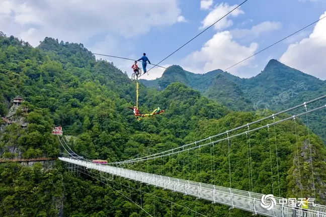 Danlu Mountain · 丹炉山
Danlu Mountain丹炉山
Danlushan is a hill at Danlu hamlet in Wu'ai town, Nandan County, in the Hechi region of northern Guangxi, where the remains of a Ming-dynasty alchemy site survive together with the ruins of an old town.
Read the place guide →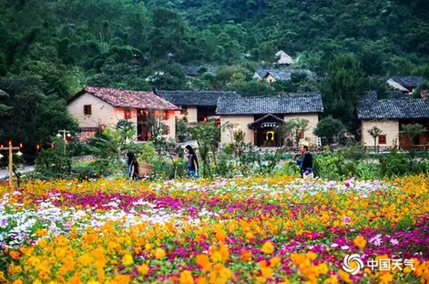 Geyasigu Baiku Yao Folk Culture Park · 歌娅思谷白裤瑶民俗区
Geyasigu Baiku Yao Folk Culture Park歌娅思谷白裤瑶民俗区
Geyasigu, in full the Geyasigu China Baiku Yao Ecological Folk Custom Park, is a developed rural tourism area in Lihu Yao Ethnic Township in the east of Nandan County, Hechi, Guangxi, assembled from Baiku Yao villages, farmland, a river and an underground-river cave.
Read the place guide →Plan your visit
Getting there
Nandan County is about 65 km in a straight line from central Hechi. Search for 南丹县 in a map app to find stations and your accommodation.
Where to stay →Build your route
Danlu Mountain and Geyasigu Baiku Yao Folk Culture Park are both listed here. The linked place guides have entrance and visit details.
Continue with Hechi →More in Hechi
Sources & geographic information
Administrative names and parent areas: Official geographic directory · Reference date 2026-09-06.
Photo: Danlu Mountain · Source photographer · License not provided. EXIF orientation normalized; resized without changing aspect ratio; converted to WebP. No subject edits.
Photo: Geyasigu Baiku Yao Folk Culture Park · Source photographer · License not provided. EXIF orientation normalized; resized without changing aspect ratio; converted to WebP. No subject edits.
Map data © OpenStreetMap contributors. Pins mark approximate centres, not entrances or boundaries.