


Get to know Pu'an County
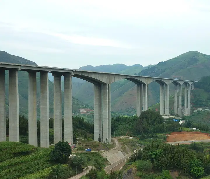
Photo adjustments
EXIF orientation normalized; resized without changing aspect ratio; converted to WebP. No subject edits.
- Administrative area
- County · 县
- Part of
- Qianxinan Buyei and Miao Autonomous Prefecture
- Chinese name
- 普安县
- Local areas
- County guide
Area & population
- Area in the source
- 1,429.00 km²
- Population · 2010
- 254,328
- Administrative seat
- Panshui
Source: cited geographic source, as of the dates shown.
Setting and landscape
The Wumeng range crosses the middle of the county and splits it in two: the southern half slopes to the south-west and the northern half to the north-east. The land averages 1,400 metres; the highest point, Changchong Liangzi (长冲梁子) near Lianhua Mountain (莲花山), reaches 2,084.6 metres, and the Shigu River valley (石古河) in the north drops to 633 metres. Karst is widespread, and the rivers drain to the Nanpan and Beipan in roughly equal shares. Black-leaf monkeys and black-necked cranes, both first-class protected species, live here.
History
The area belonged to the Yelang state in the Spring and Autumn and Warring States periods and became Loujiang County (漏江县) under the Han in 111 BC. The name Pu'an dates from 1276, when the Yuan court created the Pu'an Route (普安路) to celebrate the end of the fighting and the unification of Yunnan and Guizhou. The county itself was set up in 1661, and in 1683 its seat moved to Xinxingsuo (新兴所), today's county town.
What to see
The Tongushan site (铜鼓山遗址), on a hilltop in Qingshan town (青山镇), was a bronze-casting workshop of the Warring States to Western Han period, found in 1978. More than 500 moulds were recovered for halberds, swords, axes, arrowheads and fish hooks, and the county government describes it as the only formally excavated bronze-casting site of that age in Guizhou. It became a national key cultural relics protection unit in 2013 and is one of eleven sites in the Pu'an Yelang site group (普安夜郎遗址群).
The Qingshan cave group (青山溶洞群), 47 kilometres south of the county seat on the flat Yelang basin (夜郎坝), is a karst maze of dry and water caves, dragon pools and ponds along the Daisu (歹苏河) and Lü (绿河) rivers, which run underground and resurface. The county's section of the Tea Horse Road (茶马古道) is also on the national protected list.
Food and local products
In 1980 a four-seeded tea seed fossil, dated to 1.64 million years ago, was found on Yuntou Mountain (云头大山) on the border with Qinglong. The county holds more than 20,000 wild four-seeded ancient tea trees, over 3,000 of them more than 1,000 years old, and its Pu'an Hong (普安红) tea was named a "Chinese cultural famous tea". Spring tea from the core growing area reaches market about 20 days before other regions. The Miao reed-pipe dance Reaidegen (惹捱德亘) is on the national intangible heritage list, and Longxi stone inkstones (龙溪石砚) on the provincial one.
Highlights
- Tongushan site 铜鼓山遗址: Warring States to Western Han bronze-casting workshop; national key protection unit since 2013.
- Qingshan cave group 青山溶洞群: Karst caves, pools and underground rivers on the Yelang basin 47 km south of the county seat.
- Pu'an Hong tea 普安红: Named a Chinese cultural famous tea; the county has over 20,000 wild four-seeded ancient tea trees.
Sources for this guide
普安县情介绍 · Pu'an County People's Government
普安县人民政府网站-历史沿革 · Pu'an County People's Government
普安县人民政府网站-自然地理 · Pu'an County People's Government
铜鼓山遗址 · Pu'an County People's Government
普安夜郎遗址群 · Pu'an County People's Government
青山溶洞群 · Pu'an County People's Government
Original English written from the listed sources and checked sentence by sentence against quoted extracts by a separate reviewer. Updated 2026-09-24.
Explore Pu'an County
Core places to explore, with English and Chinese names.
Pu'an County 普安县
Plan your visit
Getting there
Pu'an County is about 75 km in a straight line from central Qianxinan Buyei and Miao Autonomous Prefecture. Search for 普安县 in a map app to find stations and your accommodation.
Where to stay →More in Qianxinan Buyei and Miao Autonomous Prefecture
Sources & geographic information
Administrative names and parent areas: Official geographic directory · Reference date 2026-09-06.
Map data © OpenStreetMap contributors. Pins mark approximate centres, not entrances or boundaries.