


Get to know Qinglong County
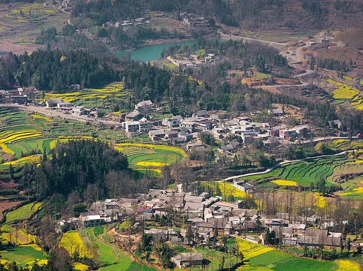
Photo adjustments
Full-frame source proportionally resized and converted to WebP for display. No subject alteration. Source-supplied marks and edits remain; cards may crop the view.
- Administrative area
- County · 县
- Part of
- Qianxinan Buyei and Miao Autonomous Prefecture
- Chinese name
- 晴隆县
- Local areas
- County guide
Area & population
- Area in the source
- 1,327.00 km²
- Population · 2020
- 234,162
- Administrative seat
- Liancheng
Source: cited geographic source, as of the dates shown.
Setting and landscape
Qinglong belongs to the Beipan River basin of the Pearl River system. Across the Beipan to the east is Guanling Buyei and Miao Autonomous County (关岭布依族苗族自治县), and the river also marks the northern boundary with Shuicheng (水城) and Liuzhi (六枝); Xingren (兴仁) lies to the south and Pu'an (普安) to the west. The land is higher in the west and south. The top point, 2,025 metres, is near the Pu'an border, and the lowest, 543 metres, is where the Masha River (麻沙河) joins the Beipan. Fifteen rivers drain into the Beipan, which has cut valleys 500 to 700 metres deep, giving the "high mountains, deep valleys, steep slopes" landscape the county government describes. The Guangzhao (光照) hydropower station has been built in the county.
History
Under the Ming the area was held by the Annan Guard (安南卫), a garrison that was abolished and replaced by Annan County in 1687. The Republican government renamed the county Qinglong in 1941. Qinglong was merged into Pu'an County in December 1958 and restored in August 1961. The county government lists the Panjiang iron-chain bridge (盘江铁索桥) and Ming and Qing cliff inscriptions on the Panjiang among its historic remains.
What to see
The Twenty-Four Bends, known in old times as Ya Pass (鸦关), climbs about 260 metres over a straight-line distance of roughly 350 metres, folding into S-shaped bends for about 4 kilometres up to the pass. The scenic area has an exhibition hall with photographs, video and objects.
Amei Qituo (阿妹戚托), a dance of the Yi people of Sanbao (三宝), is danced through the night when a daughter leaves home to marry; locals also call it the "foot-stamping dance". The Sanbao Yi, a White Yi branch, came from Yunnan in the Hongwu reign of the Ming. The dance has twelve sets of movements, originally performed without music and kept in step by stamping, was performed in Beijing in 1956, and entered the national intangible heritage list in December 2014.
Highlights
- Twenty-Four Bends 二十四道拐: S-bend wartime road about 4 km long, the visual symbol of the Stilwell Road.
- Amei Qituo 阿妹戚托: Yi wedding dance of Sanbao, national intangible heritage since 2014.
- Panjiang iron-chain bridge 盘江铁索桥: Listed by the county government among its historic remains.
Sources for this guide
晴隆县人民政府-晴隆简介 · Qinglong County People's Government
晴隆县人民政府-历史沿革 · Qinglong County People's Government
晴隆:乐享假日时光 畅游二十四道拐 · Qinglong County People's Government
阿妹戚托舞蹈文化精神内涵 · Qinglong County People's Government
Original English written from the listed sources and checked sentence by sentence against quoted extracts by a separate reviewer. Updated 2026-09-24.
Explore Qinglong County
Core places to explore, with English and Chinese names.
Places to explore around Qinglong County
 A 1944-45 US Army aerial photograph in black and white of a bare, terraced mountainside with a road cut into it as a long ladder of hairpin bends running from the lower right to the upper left, a few vehicles on the bends, and the archival number 191666-S printed at the lower right.
Plan your visit
Getting there
Qinglong County is about 90 km in a straight line from central Qianxinan Buyei and Miao Autonomous Prefecture. Search for 晴隆县 in a map app to find stations and your accommodation.
Where to stay →Build your route
Start with Twenty-Four Bends. The linked place guides have entrance and visit details.
Continue with Qianxinan Buyei and Miao Autonomous Prefecture →More in Qianxinan Buyei and Miao Autonomous Prefecture
Sources & geographic information
Administrative names and parent areas: Official geographic directory · Reference date 2026-09-06.
Photo: Twenty-Four Bends · Unknown authorUnknown author or not provided · Public domain. Full frame retained; proportionally resized and converted to WebP. No retouching or changes to the photographed subject. Card displays may crop the view.

Map data © OpenStreetMap contributors. Pins mark approximate centres, not entrances or boundaries.