


Get to know Fenggang County
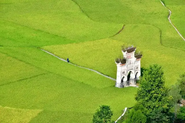
Photo adjustments
EXIF orientation normalized; resized without changing aspect ratio; converted to WebP. No subject edits.
- Administrative area
- County · 县
- Part of
- Zunyi City
- Chinese name
- 凤冈县
- Local areas
- County guide
Area & population
- Area in the source
- 1,883.00 km²
- Population · 2010
- 313,005
- Administrative seat
- Longquan
Source: cited geographic source, as of the dates shown.
Setting and landscape
Fenggang borders seven counties, among them Sinan (思南), Meitan (湄潭) and Wuchuan (务川), and covers about 1,885 square kilometres. The average altitude is 720 metres, the climate is mid-subtropical humid monsoon, and the county records a mean annual temperature of 15.2°C and about 1,200 mm of rain a year, with winters free of hard cold and summers free of great heat. Besides tea, farmers grow rice, rapeseed, tobacco, chilli and peanuts.
History
Under the Yuan the Dabao Longquan chieftain's office (大保龙泉长官司) had its seat at present-day Fenggang. In 1601 the Ming replaced it with Longquan County (龙泉县) under Shiqian Prefecture (石阡府). The county was renamed Fengquan (凤泉县) in September 1913 and Fenggang in 1930. It was merged into Meitan County in December 1958, and a State Council decision of 16 August 1961 restored it.
What to see
The Heart of the Tea Sea (茶海之心景区) is the county's national 4A scenic area. The 3A list covers Jiulong (九龙), the Educated Youth Culture Park (知青文化园), Chashou Mountain (茶寿山), Manao Mountain (玛瑙山), the old village of Changqi (长碛古寨) and Baiziding (柏梓顶). The Manao Mountain barracks site (玛瑙山营盘遗址) is a national key protected site, and the county government describes Manao Mountain's ancient military cave fortress as the best preserved in southwest China.
Older traces include the Ming cliff inscription "Yelang Gudian" (夜郎古甸, 'the ancient land of Yelang'), the inscription "Wangu Huiyou" (万古徽猷, 'lasting wise counsel') on Zhonghua Mountain (中华山), the Taiji Cave (太极洞), which brings Confucian, Buddhist and Taoist culture together, and a cliff carving of the character feng (凤, 'phoenix'). The county also holds a land-plant fossil, Qianyuzhi (黔羽枝), dated to about 450 million years ago. Longtan River (龙潭河) has a national wetland park and Pushui River (蒲水河) a provincial one.
Food and local products
Fenggang zinc-selenium tea (凤冈锌硒茶) was in the first batch of geographical indications mutually recognised by China and the EU, and Fenggang beef (凤冈牛肉) is on the national register of distinctive agricultural products. Folk traditions named by the county include silk-string lanterns (丝弦灯), push lanterns (推推灯), flower lanterns (花灯), tea lanterns (茶灯), high-platform lion lanterns (高台狮灯), the washbasin dragon (脚盆龙), suona bands, and Nuo opera (傩戏).
Getting oriented
The county places itself between the Zunyi Conference Site (遵义会议会址) and the Buddhist mountain Fanjingshan (梵净山). The Hangzhou–Ruili (杭瑞), Yinchuan–Baise (银百), Dejiang–Yuqing (德余) and Meitan–Shiqian (湄石) expressways reach the county, and National Road 326 crosses it. Zunyi Xinzhou Airport (遵义新舟机场) is 68 km away and Zunyi's high-speed rail station 96 km.
Highlights
- Heart of the Tea Sea 茶海之心景区: The county's national 4A scenic area.
- Manao Mountain barracks site 玛瑙山营盘遗址: National key protected site at Manao Mountain, one of the county's 3A scenic areas.
- Fenggang zinc-selenium tea 凤冈锌硒茶: In the first batch of China–EU mutually recognised geographical indications.
Sources for this guide
凤冈县基本概况 · Fenggang County People's Government
凤冈县人民政府-历史沿革 · Fenggang County People's Government
凤冈县人民政府-自然地理 · Fenggang County People's Government
Original English written from the listed sources and checked sentence by sentence against quoted extracts by a separate reviewer. Updated 2026-09-24.
Explore Fenggang County
Core places to explore, with English and Chinese names.
Fenggang County 凤冈县
Plan your visit
Getting there
Fenggang County is about 70 km in a straight line from central Zunyi City. Search for 凤冈县 in a map app to find stations and your accommodation.
Where to stay →More in Zunyi City
Sources & geographic information
Administrative names and parent areas: Official geographic directory · Reference date 2026-09-06.
Map data © OpenStreetMap contributors. Pins mark approximate centres, not entrances or boundaries.