


Get to know Cangxian
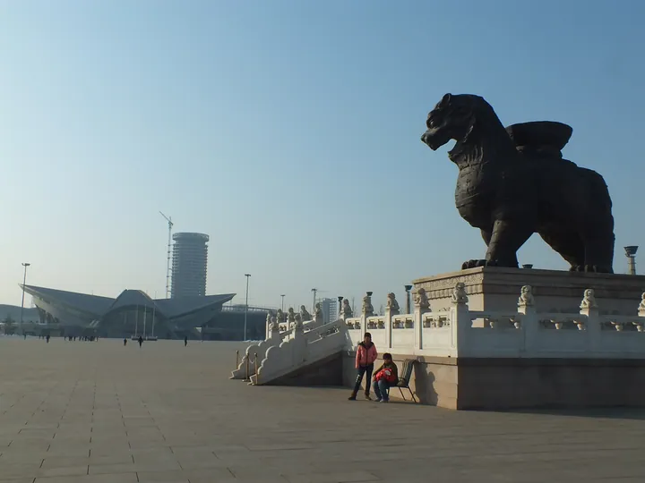
Photo adjustments
Full frame retained; proportionally resized and converted to WebP. No retouching or changes to the photographed subject. Card displays may crop the view.
- Administrative area
- County · 县
- Part of
- Cangzhou
- Chinese name
- 沧县
- Local areas
- County guide
Area & population
- Area in the source
- 1,527.00 km²
- Population · 2020
- 626,011
Source: cited geographic source, as of the dates shown.
Setting and landscape
The county is a flat alluvial plain that drops from about 11 metres above sea level around Gaochuan (高川) to 4 metres in the north-east. It has many depressions; the best known, Dalangdian (大浪淀) east of the canal, covers about 4,667 hectares. Rivers in the west belong to the Heilonggang (黑龙港) system, while east of the canal man-made drainage channels run straight to the Bohai Sea. Old river courses show up clearly on remote-sensing images, and orchards grow along them. The eastern townships are coastal plain below 5 metres, with much waterlogged low ground.
History
The Western Han set up Fuyang county (浮阳县), governed from the old town at today's Dongguan village (东关村). Cangzhou prefecture was created in 517, and Fuyang was renamed Qingchi (清池) in 598. In 1369 the prefecture moved its seat to Changlu town (长芦镇), today's Cangzhou city, and absorbed Qingchi; in 1913 Cangzhou was renamed Cang County. In 1961 the county-seat area was split off from the county to form Cangzhou city.
What to see
The Iron Lion of Cangzhou (沧州铁狮子), also called Zhenhaihou (镇海吼, "roar that calms the sea"), stands inside the ancient city at Jiuzhou (旧州镇). An inscription dates its casting to 953 under the Later Zhou. The hollow iron beast is 6.26 metres long, 5.47 metres high and weighs 32 tonnes, and it is counted among the four ancient treasures of Hebei. It was blown over in 1803, set upright in 1893 and moved 8 metres north in 1983, and it was on the first list of national key protected sites in 1961.
The Hebei Cultural Relics Bureau lists more sites in the county. The Song-era old Cangzhou city (沧州旧城) and the Ming Dengying Bridge (登瀛桥) have been national key sites since 2013, and the Ming and Qing Jiedi flood-diversion sluice (捷地分洪闸设施) is now part of the Grand Canal national site. Provincial listings include a Han tomb at Qiangaolonghua (前高龙华古墓) said to be that of Yuan Shao (袁绍), and a Ming stone Bodhisattva at Haimatou (海码头石菩萨).
Food and local products
Cangxian is known as China's home of golden-silk jujubes (金丝小枣), with about 191,000 mu of jujube orchards. The county government describes its jujube and dried-nut market as the largest in China; in 2025 it hosted the China (Cangxian) jujube and dried-nut expo under the slogan "jujube fragrance along the canal".
Highlights
- Iron Lion of Cangzhou 沧州铁狮子: Hollow iron lion cast in 953, 32 tonnes; national key protected site since 1961.
- Old Cangzhou city 沧州旧城: Site of the Song-era city; national key protected site since 2013.
- Dengying Bridge 登瀛桥: Ming bridge; national key protected site since 2013.
- Golden-silk jujubes 金丝小枣: The county calls itself China's home of golden-silk jujubes.
Sources for this guide
自然地理_沧县人民政府 · Cangxian People's Government
历史沿革_沧县人民政府 · Cangxian People's Government
沧县 - 维基百科,自由的百科全书 · Wikipedia (Chinese) · CC BY-SA 4.0
沧州铁狮子 - 维基百科,自由的百科全书 · Wikipedia (Chinese) · CC BY-SA 4.0
河北省第一至六批省级文物保护单位汇总表_河北省文物局 · Hebei Provincial Cultural Relics Bureau
“枣香运河 红动中国”——2025中国(沧县)红枣及干坚果休闲食品博览会暨产业发展大会开幕_沧县人民政府 · Cangxian People's Government
Original English written from the listed sources and checked sentence by sentence against quoted extracts by a separate reviewer. Updated 2026-09-24.
Explore Cangxian
Core places to explore, with English and Chinese names.
Plan your visit
Getting there
Cangxian covers the centre of Cangzhou. Search for 沧县 in a map app to find stations and your accommodation.
Where to stay →More in Cangzhou
Sources & geographic information
Administrative names and parent areas: Official geographic directory · Reference date 2026-09-06.
Some facts checked against 沧县 — Wikipedia contributors, CC BY-SA 4.0.
Some facts checked against 沧州铁狮子 — Wikipedia contributors, CC BY-SA 4.0.
Map data © OpenStreetMap contributors. Pins mark approximate centres, not entrances or boundaries.