


Get to know Changli County
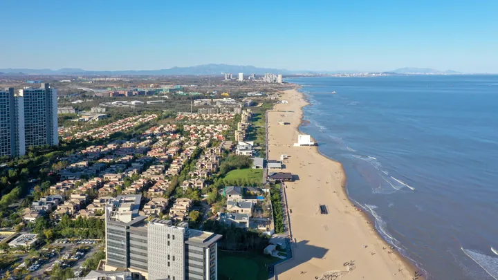
Photo adjustments
Full frame retained; proportionally resized and converted to WebP. No retouching or changes to the photographed subject. Card displays may crop the view.
- Administrative area
- County · 县
- Part of
- Qinhuangdao
- Chinese name
- 昌黎县
- Local areas
- County guide
Area & population
- Population · 2020 census
- 487,989
- Administrative seat
- Changli Town (昌黎镇)
Source: cited geographic source, as of the dates shown.
History
The present county grew from Guangning County (广宁县), set up by the Khitan in 923 to house captives from Dingzhou (定州). The Jin renamed it Changli in 1189, from a phrase wishing prosperity on the common people. The Changli of the Han and Wei-Jin periods was a different county, now Yi County (义县).
What to see
Jieshi Mountain is one part of the Changli Jieshi National Park (昌黎碣石国家公园), which covers about 102 square kilometres some 25 kilometres from Beidaihe (北戴河). Its main peak, Xiantai Summit (仙台顶), reaches 695 metres, and the Qinhuangdao government calls it the highest peak near the Bohai shore. The name refers to the pillar-shaped top; the mountain appears in the "Classic of Mountains and Seas" (山海经) and the "Tribute of Yu" (禹贡), and nine emperors are recorded as climbing it. Sights on the mountain include the Tianqiao Pillar (天桥柱), Wufeng Mountain (五峰山), Longtan Cave (龙潭洞) and Shuiyan Temple (水岩寺).
In the northwest of the county town stands the Yuanying Temple Pagoda (源影寺塔), a Jin-dynasty solid brick-and-timber pagoda of thirteen close-set eaves, octagonal and about 36 metres high, listed as a national protected site in 2001.
The Gold Coast beach runs 47 kilometres from the south bank of the Dapu River (大蒲河) to the mouth of the Luan River (滦河), 50 to 120 metres wide and mainly fine sand. With the Qilihai lagoon (七里海) and the Luan estuary wetlands, a noted birdwatching site, it forms a national nature reserve; the coast is now run by the Beidaihe New Area (北戴河新区).
Food and local products
Changli makes wine: the Qinhuangdao government describes a cluster that covers wine-grape growing, winemaking, bottle making and oak barrels, and the national park includes a Grape Town (葡萄小镇) built on the former Grape Valley scenic area, one of China's first national agricultural-tourism demonstration sites in 2005.
Two local performing arts are on the national intangible-heritage list: Changli ground yangge (昌黎地秧歌), a folk dance dating from the Yuan dynasty in which men once played every role, listed in 2006; and Changli shadow puppetry (昌黎皮影戏), listed in 2011, which unlike most shadow theatre has its own singing style drawn from Changli folk songs.
Highlights
- Jieshi Mountain 碣石山: Main peak Xiantai Summit, 695 m; named in the Classic of Mountains and Seas and the Tribute of Yu.
- Yuanying Temple Pagoda 源影寺塔: Jin-dynasty thirteen-eave pagoda about 36 m high; national protected site since 2001.
- Changli Gold Coast 昌黎黄金海岸: 47 km fine-sand beach from the Dapu River to the Luan River mouth; part of a national nature reserve.
- Grape Town 葡萄小镇: Grape-growing area in Jieshi National Park, a national agricultural-tourism demonstration site from 2005.
- Changli shadow puppetry 昌黎皮影戏: National intangible heritage (2011), sung in its own style based on Changli folk songs.
Sources for this guide
碣石国家公园葡萄小镇-秦皇岛市人民政府 · Qinhuangdao Municipal People's Government
昌黎县 · Wikipedia (Chinese) · CC BY-SA 4.0
源影寺塔 · Wikipedia (Chinese) · CC BY-SA 4.0
黄金海岸 (昌黎) · Wikipedia (Chinese) · CC BY-SA 4.0
秧歌(昌黎地秧歌) · China Intangible Cultural Heritage Network (Chinese National Academy of Arts)
皮影戏(昌黎皮影戏) · China Intangible Cultural Heritage Network (Chinese National Academy of Arts)
Original English written from the listed sources and checked sentence by sentence against quoted extracts by a separate reviewer. Updated 2026-09-24.
Explore Changli County
Core places to explore, with English and Chinese names.
Places to explore around Changli County
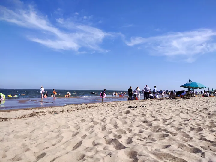 A broad sandy beach with bathers and a blue parasol along the waterline, calm sea behind and a blue sky streaked with cirrus.
Changli Golden Coast黄金海岸
Changli's Golden Coast (黄金海岸) is a Bohai coastal landscape where sandy beaches meet dunes and woodland.
Read the place guide → AI illustration · AI 示意图(仅供参考,非该地点实拍)
Aranya Cultural and Coastal Area阿那亚公共文化与海岸片区
Aranya's cultural and coastal area (阿那亚公共文化与海岸片区) brings contemporary arts venues into a beach, wetland and woodland setting on the Golden Coast.
Read the place guide →Plan your visit
Getting there
Changli County is about 35 km in a straight line from central Qinhuangdao. Search for 昌黎县 in a map app to find stations and your accommodation.
Where to stay →Build your route
Changli Golden Coast and Aranya Cultural and Coastal Area are both listed here. The linked place guides have entrance and visit details.
Continue with Qinhuangdao →More in Qinhuangdao
Sources & geographic information
Administrative names and parent areas: Official geographic directory · Reference date 2026-09-06.
Some facts checked against 昌黎县 — Wikipedia contributors, CC BY-SA 4.0.
Some facts checked against 源影寺塔 — Wikipedia contributors, CC BY-SA 4.0.
Some facts checked against 黄金海岸 (昌黎) — Wikipedia contributors, CC BY-SA 4.0.
Photo: Changli Golden Coast · 云在动 · CC BY-SA 4.0. Full frame retained; proportionally resized and converted to WebP. No retouching or changes to the photographed subject. Card displays may crop the view.

Map data © OpenStreetMap contributors. Pins mark approximate centres, not entrances or boundaries.