


Get to know Qinglong Manchu Autonomous County
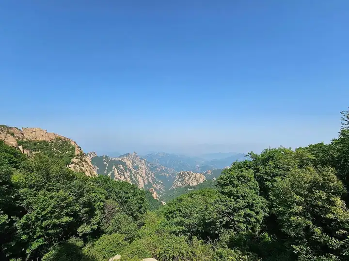
Photo adjustments
EXIF orientation normalized; resized without changing aspect ratio; converted to WebP. No subject edits.
- Administrative area
- Autonomous county · 自治县
- Part of
- Qinhuangdao
- Chinese name
- 青龙满族自治县
- Local areas
- Autonomous county guide
Area & population
- Area in the source
- 3,309.00 km²
- Population · 2020 census
- 431,138
- Administrative seat
- Qinglong Town
Source: cited geographic source, as of the dates shown.
Setting and landscape
Five river systems cross the county: the Qinglong River (青龙河), the Sha River (沙河), the Duyuan River (都源河), the Xinggan River (星干河) and the Qi River (起河). Forest covers 65.66 percent of the land.
Mount Dushan (都山), in the northwest, rises to 1,846 metres, the highest point in Qinhuangdao and the second-highest peak of the Yan Mountains (燕山). "Snow on Dushan" (都山积雪) heads the Eight Views beyond the Pass (口外八景): even in the heat of summer the summit looks white, because its field of boulders shines in the sun.
History
People lived here in the Palaeolithic, and under the Shang the area belonged to Guzhu (孤竹). In the 1120s Huilibao (回离保), king of the six Xi (奚) tribes under the Liao, proclaimed a Xi state on Zushan; it lasted about half a year. A Jin-dynasty distilling vessel found in the county is regarded by scholars as evidence that Chinese distilled liquor began here.
Manchu families settled in large numbers in the ninth year of the Kangxi reign, and Manchu dances such as the "monkey beats the stick" (猴打棒) and cunzi yangge (满族寸子秧歌) are on Hebei's intangible heritage list. The Japanese army created Qinglong County in June 1933, under Manchukuo's Rehe province. The county joined Hebei in 1955, came under Qinhuangdao in 1983, and became a Manchu autonomous county on 2 December 1986.
What to see
Zushan (祖山) is a national 4A scenic area, national scenic area and national geopark. Weathering, glaciation and running water have shaped its granite into cliffs, boulder fields, waterfalls and gorges. It is divided into five areas: Hualang Valley (画廊谷) for rock formations, Feipu Valley (飞瀑谷) for waterfalls, Wulong Valley (乌龙谷) for historic remains, the Wanghai Temple (望海寺) area, and Tiannü Peak (天女峰). Ming generals Xu Da (徐达) and Qi Jiguang (戚继光) built and fortified the Great Wall on the mountain, and the rare Siebold's magnolia (天女木兰) grows there.
The Gold Cave (黄金溶洞), also called Yinhua Jindong (银花金洞), was found by gold miners in 2001 at Shishangou (石山沟) in the southwest. Its karst passages hold stalactites alongside veins of gold, and seven levels have been explored.
Food and local products
Chestnuts cover more than a million mu, and "Qinglong chestnut" (青龙板栗) is a national geographical-indication trademark. The county also calls itself the home of apples and of nian doubao (粘豆包), sticky bean buns.
Getting oriented
The county lies about 220 kilometres from Beijing and 90 kilometres from Qinhuangdao port. The Chengde–Qinhuangdao Expressway (承秦高速) crosses the county from west to east.
Highlights
- Zushan 祖山: National 4A scenic area and geopark with granite peaks, five scenic valleys and Ming Great Wall sections.
- Mount Dushan 都山: At 1,846 metres the highest peak in Qinhuangdao; its white boulder field is the old view "Snow on Dushan".
- Gold Cave 黄金溶洞: Karst cave found by gold miners in 2001, with stalactites and gold veins over seven explored levels.
- Qinglong chestnut 青龙板栗: National geographical-indication trademark; chestnut orchards cover over a million mu.
Sources for this guide
青龙满族自治县人民政府 - 青龙满族自治县概况 · Qinglong Manchu Autonomous County People's Government
青龙满族自治县人民政府 - 历史沿革 · Qinglong Manchu Autonomous County People's Government
青龙满族自治县人民政府 - 祖山景区 · Qinglong Manchu Autonomous County People's Government
青龙满族自治县人民政府 - 都山景区 · Qinglong Manchu Autonomous County People's Government
青龙满族自治县人民政府 - 黄金溶洞景区 · Qinglong Manchu Autonomous County People's Government
Original English written from the listed sources and checked sentence by sentence against quoted extracts by a separate reviewer. Updated 2026-09-24.
Explore Qinglong Manchu Autonomous County
Core places to explore, with English and Chinese names.
Places to explore around Qinglong Manchu Autonomous County
 AI illustration · AI
 Plan your visit
Getting there
Qinglong Manchu Autonomous County is about 75 km in a straight line from central Qinhuangdao. Search for 青龙满族自治县 in a map app to find stations and your accommodation.
Where to stay →Build your route
Start with Mount Zushan. The linked place guides have entrance and visit details.
Continue with Qinhuangdao →More in Qinhuangdao
Sources & geographic information
Administrative names and parent areas: Official geographic directory · Reference date 2026-09-06.
Map data © OpenStreetMap contributors. Pins mark approximate centres, not entrances or boundaries.