


Get to know Funing District
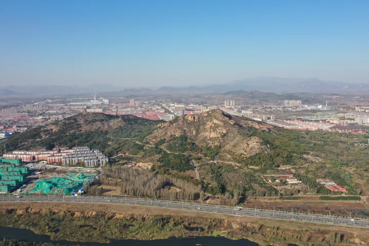
Photo adjustments
Full frame retained; proportionally resized and converted to WebP. No retouching or changes to the photographed subject. Card displays may crop the view.
- Administrative area
- District · 市辖区
- Part of
- Qinhuangdao
- Chinese name
- 抚宁区
- Local areas
- District guide
Area & population
- Area in the source
- 1,618.00 km²
- Population · 2020 census
- 291,211
- Administrative seat
- Licheng Subdistrict (骊城街道)
Source: cited geographic source, as of the dates shown.
Setting and landscape
The district government describes Funing as the only district in China with mountains, rivers, lakes, sea and the Great Wall together. Haigang (海港区), Beidaihe (北戴河区) and Qinglong Manchu Autonomous County (青龙满族自治县) border it to the east and north, and Changli (昌黎) and Lulong (卢龙) counties to the west.
History
Under the Shang and Zhou the area belonged to the state of Guzhu (孤竹国). A Funing County was first set up in 619 under the Tang and re-established in 1189 under the Jin. In 1737 the land east of the Shen River (深河) was split off to create Linyu County (临榆县) at Shanhaiguan (山海关). When the county became a district in 2015, the towns of Shimenzhai (石门寨), Zhucaoying (驻操营) and Duzhuang (杜庄) passed to Haigang and Niutouya (牛头崖) to Beidaihe, about a third of its area.
What to see
About 60 kilometres of the Great Wall remain in the district, from Beiniuding (背牛顶) in Daxinzhai Town (大新寨镇) west to Ganjian village (干涧村) in Taiying Town (台营镇), with seven passes and 224 watchtowers. Xu Da (徐达) first built it in the early Ming, and Qi Jiguang (戚继光) rebuilt it on a large scale; the district government calls it one of the finest parts of the Ming Jizhen (蓟镇) wall. Towers between Luojiagou (罗家沟) and Chengjiagou (程家沟) still hold six inscriptions cut with bayonets by Japanese soldiers.
The Bingtangyu Great Wall Canyon (冰塘峪长城风情大峡谷) in Daxinzhai Town lies right below the Ming wall. According to the Hebei Economic Daily, cold air rising from the ground there freezes into ice from late April to late July. The canyon holds the Dragon Scale Dam (龙鳞坝), a series of stepped green weirs, and a cliff carved with more than a hundred styles of the character fu (福, "good fortune"). The Qi Jiguang Border Defence Culture Museum (戚继光戍边文化博物馆), a branch of the Funing District Museum, opened there in May 2023.
On the coast, the Nandaihe International Amusement Centre (南戴河国际娱乐中心), which the district government calls a long-established scenic area, has a lotus garden (中华荷园), sand and grass slides and a bathing beach.
Getting oriented
The urban area is 23 kilometres from central Qinhuangdao and 240 kilometres from Beijing. The Tianjin–Qinhuangdao (津秦客运专线) and Beijing–Qinhuangdao (京秦高铁) high-speed lines and the Beijing–Shenyang Expressway (京沈高速公路) cross the district.
Highlights
- Funing Great Wall 抚宁长城: About 60 km of Ming wall with seven passes and 224 watchtowers, from Beiniuding to Ganjian village.
- Bingtangyu Great Wall Canyon 冰塘峪长城风情大峡谷: Canyon under the Ming wall in Daxinzhai Town where ice forms from late April to late July.
- Qi Jiguang Border Defence Culture Museum 戚继光戍边文化博物馆: Branch of the Funing District Museum at Bingtangyu, opened in May 2023.
- Nandaihe International Amusement Centre 南戴河国际娱乐中心: Long-established seaside scenic area with a lotus garden, sand and grass slides and a bathing beach.
Sources for this guide
历史沿革 - 抚宁区人民政府 · Funing District People's Government
自然地理 - 抚宁区人民政府 · Funing District People's Government
抚宁:做好“+旅游”大文章 加快建设文化旅游强区 · Funing District People's Government
来长城风情大峡谷,感受壮阔神秘之美! · China Tourism News (Great Wall National Cultural Park site)
冰塘峪长城大峡谷 获评4A级景区 · Hebei Economic Daily
Original English written from the listed sources and checked sentence by sentence against quoted extracts by a separate reviewer. Updated 2026-09-24.
Explore Funing District
Core places to explore, with English and Chinese names.
Places to explore around Funing District
 AI illustration · AI
 Plan your visit
Getting there
Funing District is about 25 km in a straight line from central Qinhuangdao. Search for 抚宁区 in a map app to find stations and your accommodation.
Where to stay →Build your route
Start with Bingtangyu Valley. The linked place guides have entrance and visit details.
Continue with Qinhuangdao →More in Qinhuangdao
Sources & geographic information
Administrative names and parent areas: Official geographic directory · Reference date 2026-09-06.
Map data © OpenStreetMap contributors. Pins mark approximate centres, not entrances or boundaries.