


Get to know Jingxing County
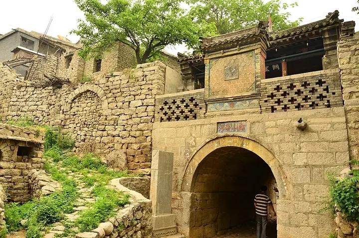
Photo adjustments
Full frame retained; proportionally resized and converted to WebP. No retouching or changes to the photographed subject. Card displays may crop the view.
- Administrative area
- County · 县
- Part of
- Shijiazhuang
- Chinese name
- 井陉县
- Local areas
- County guide
Area & population
- Area in the source
- 1,380.00 km²
- Population · 2020 census
- 250,989
Source: cited geographic source, as of the dates shown.
History
The Jingxing Pass counts as the fifth of the Eight Passes of the Taihang (太行八陉) and the sixth of the Nine Fortresses of ancient China. The county was set up in 221 BC under the First Emperor of Qin, and it was the first pilot county for the national title of "thousand-year-old county" (千年古县). Palaeolithic tools found at Sunzhuang (孙庄) in the 1990s show how early people used the route. Sima Qian recorded the Jingxing road in the Shiji, and ruts more than a foot deep can still be seen on the old post road (古驿道).
In 204 BC the Han general Han Xin (韩信) crossed the Taihang with about ten thousand new recruits and met a Zhao army of two hundred thousand at the Jingxing Pass. He drew up his main force with its back to the river, while two thousand horsemen with red Han banners slipped round and took the empty Zhao camp. Seeing Han banners behind them, the Zhao ranks fell into disorder and were routed.
What to see
Cangyan Mountain (苍岩山), about 40 kilometres south of the county town, became a national key scenic area in 1988. Its Fuqing Temple (福庆寺) is built into a cliff-lined gorge, and its bridge-tower hall (桥楼殿), a hall inside a building set on a bridge spanning the gorge, is counted among China's three great hanging temples. Emperor Zhenzong of the Song granted the temple its name in 1014. Baitan trees (白檀树) on the mountain grow with bare roots wrapped around boulders.
Tianchang old town (天长古城), 5 kilometres southwest of the county town, was the county seat from the Song until the early years of the People's Republic and is a Hebei protected site. The Longwo Temple grottoes (龙窝寺石窟) hold 47 Buddha figures carved in high relief in 14 niches on a cliff beside the old Yan–Jin road; they have been a provincial protected site since 1993. The county government also names Yujia Stone Village (于家石头村) among its sights.
Jingxing lahua (井陉拉花) is a folk dance said to date from the Song or Yuan, built on twisting arms, turning wrists and lifted legs, with props such as umbrellas and bundles that each carry a wish. It was performed in Beijing in 1957 before Zhu De (朱德) and Zhou Enlai (周恩来), and the Ministry of Culture has named Jingxing a home of lahua art.
Highlights
- Cangyan Mountain 苍岩山: National key scenic area since 1988; its Fuqing Temple bridge-tower hall spans a gorge.
- Jingxing ancient post road 井陉古驿道: Road through the Jingxing Pass, recorded in the Shiji, with ruts over a foot deep.
- Tianchang old town 天长古城: County seat from the Song to the early People's Republic; a Hebei protected site.
- Longwo Temple grottoes 龙窝寺石窟: 47 high-relief Buddha figures in 14 niches; provincial protected site since 1993.
- Jingxing lahua 井陉拉花: Folk dance said to date from the Song or Yuan; the county is a named home of lahua art.
Sources for this guide
千年古县 · Jingxing County People's Government
背水之战 · Jingxing County People's Government
太行明珠--苍岩山 · Jingxing County People's Government
文物古迹 · Jingxing County People's Government
井陉拉花 · Jingxing County People's Government
Original English written from the listed sources and checked sentence by sentence against quoted extracts by a separate reviewer. Updated 2026-09-24.
Explore Jingxing County
Core places to explore, with English and Chinese names.
Places to explore around Jingxing County
 Cangyan Mountain · 苍岩山
Cangyan Mountain苍岩山
At Cangyan Mountain, the architecture is fitted into a narrow, steep-sided Taihang gorge. Fuqing Temple's Bridge-Tower Hall stands on a stone arch spanning the gap between cliffs, creating the view that made the mountain…
Read the place guide → Yujia Stone Village · 于家石头村
Yujia Stone Village于家石头村
Yujia Stone Village is a settlement in Jingxing County where stone shapes houses, lanes, terraces and water storage.
Read the place guide →Plan your visit
Getting there
Jingxing County is about 30 km in a straight line from central Shijiazhuang. Search for 井陉县 in a map app to find stations and your accommodation.
Where to stay →Build your route
Cangyan Mountain and Yujia Stone Village are both listed here. The linked place guides have entrance and visit details.
Continue with Shijiazhuang →More in Shijiazhuang
Sources & geographic information
Administrative names and parent areas: Official geographic directory · Reference date 2026-09-06.
Photo: Cangyan Mountain · Rolfmueller · CC BY-SA 3.0. Wikimedia thumbnail; fitted to the ranking-card frame.

Photo: Yujia Stone Village · Source photographer · License not provided. EXIF orientation normalized; resized without changing aspect ratio; converted to WebP. No subject edits.
Map data © OpenStreetMap contributors. Pins mark approximate centres, not entrances or boundaries.