


Get to know Wan Chai District
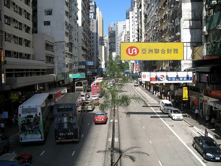
Photo adjustments
Full frame retained; proportionally resized and converted to WebP. No retouching or changes to the photographed subject. Card displays may crop the view.
- Administrative area
- District · 地區
- Part of
- Hong Kong
- Chinese name
- 灣仔
- Local areas
- District guide
Area & population
- Area in the source
- 10.20 km²
Source: cited geographic source, as of the dates shown.
Areas and setting
Besides Wan Chai itself, the district covers Causeway Bay (銅鑼灣), Happy Valley, Tai Hang (大坑), Jardine's Lookout, Stubbs Road and Wong Nai Chung Gap (黃泥涌峽). Wan Chai North, the zone north of Gloucester Road, is land reclaimed from the sea after the 1970s and holds the Hong Kong Convention and Exhibition Centre and Central Plaza; the ceremony for the handover of Hong Kong to China was held in the centre's then-new wing. The Stubbs Road Lookout faces Victoria Harbour and Bowen Road leads to Lovers' Rock (姻緣石).
What to see
The Home Affairs Department picks out the district's older buildings. The Old Wan Chai Post Office (舊灣仔郵政局) is Hong Kong's oldest post office building and a declared monument, and Hung Shing Temple (洪聖古廟) has watched the shoreline move for a century and a half. The list continues with Pak Tai Temple (玉虛宮) with its copper statue of the god Pak Tai; the 18th-century Tin Hau Temple (天后廟) in Causeway Bay; and the Jardine Noonday Gun. Old stone stairs climb from Ship Street into greenery, and Victoria Park is a green space among the city streets. A flag-raising ceremony takes place each day at Golden Bauhinia Square (金紫荊廣場) beside the convention centre, most elaborate on 1 July and 1 October.
The streets are specialised. Johnston Road and Luard Road have export clothing shops, Queen's Road East sells Chinese-style wooden furniture, Spring Garden Lane and Tai Wo Street are lined with vegetable, fruit and household stalls, and Tai Yuen Street is known as "Toy Street". Happy Valley Racecourse and Hong Kong Stadium are also in the district, as are the Hong Kong Central Library and the Police Museum near Stubbs Road.
Getting oriented
Wan Chai lies between Admiralty to the west and Causeway Bay to the east, and the district council calls it a traffic hub for the island's east-west and north-south routes. The Cross-Harbour Tunnel, the first tunnel under Victoria Harbour, runs from the former Kellett Island to Hung Hom (紅磡); since 2022 the East Rail line has crossed the harbour to a new Exhibition Centre station in Wan Chai North; and the Star Ferry sails from Wan Chai Pier to Tsim Sha Tsui (尖沙咀).
Highlights
- Golden Bauhinia Square 金紫荆广场: Beside the Hong Kong Convention and Exhibition Centre; scene of a daily flag-raising ceremony.
- Happy Valley Racecourse 跑马地马场: Named among the district's well-known facilities by the Wan Chai District Council.
- Victoria Park 维多利亚公园: Green space described by the Home Affairs Department as an oasis in the city.
- Old Wan Chai Post Office 舊灣仔郵政局: Hong Kong's oldest post office building and a declared monument.
- Pak Tai Temple 玉虛宮: Temple with a copper statue dedicated to Pak Tai.
Sources for this guide
Home Affairs Department - Wan Chai District · Home Affairs Department, Hong Kong SAR Government
Wan Chai District Council - District Highlights · Wan Chai District Council, Hong Kong SAR Government
Wan Chai District · Wikipedia · CC BY-SA 4.0
Original English written from the listed sources and checked sentence by sentence against quoted extracts by a separate reviewer. Updated 2026-09-25.
Explore Wan Chai District
Core places to explore, with English and Chinese names.
Places to explore around Wan Chai District
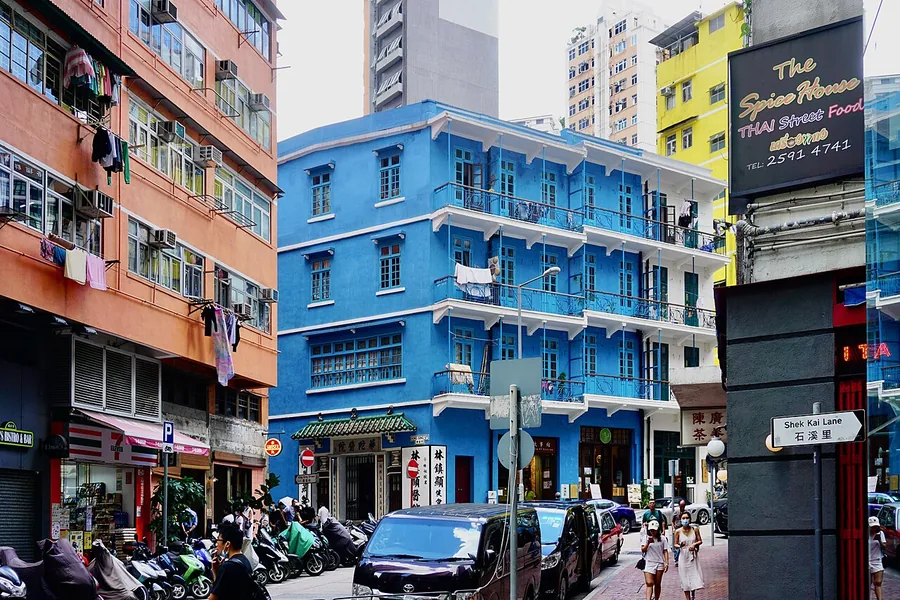 The Blue House on Stone Nullah Lane in Wan Chai, Hong Kong; 20 June 2020.
Blue House蓝屋
The Blue House is a balcony-fronted tong lau on Stone Nullah Lane in Wan Chai. Its painted blue exterior gives the building its familiar name, but the more revealing details are the projecting balconies, shop-level frontage and…
Read the place guide →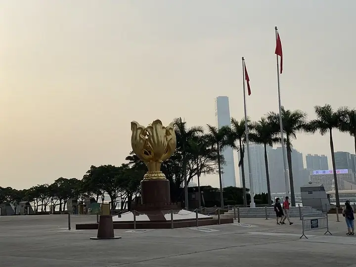 Golden Bauhinia Square monument and flagpoles · 金紫荆广场雕塑与旗杆 Photograph date recorded by the source: 5 May 2021, 17:48:27.
Golden Bauhinia Square金紫荆广场
Golden Bauhinia Square sits outside the Hong Kong Convention and Exhibition Centre on the Wan Chai waterfront. The gilded bauhinia sculpture rises from a red-granite base, with the Reunification Monument nearby. These…
Read the place guide →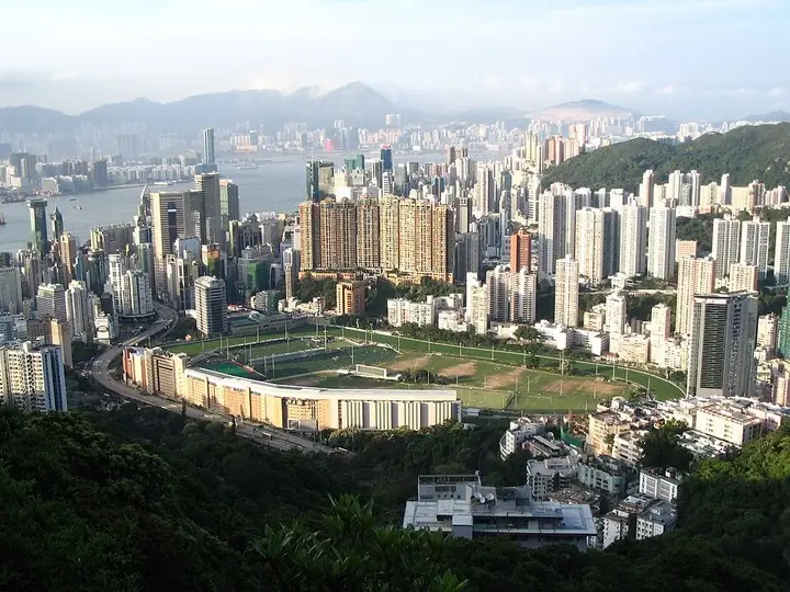 Happy Valley Racecourse and surrounding cityscape · 跑马地马场与周边城区 Photograph date recorded by the source: 4 May 2008.
Happy Valley Racecourse跑马地马场
Happy Valley Racecourse places a racing oval and grandstands within a dense urban neighbourhood. On a scheduled race day, the forecourt and winning-post area bring the movement of horses into close view, while the grandstand…
Read the place guide →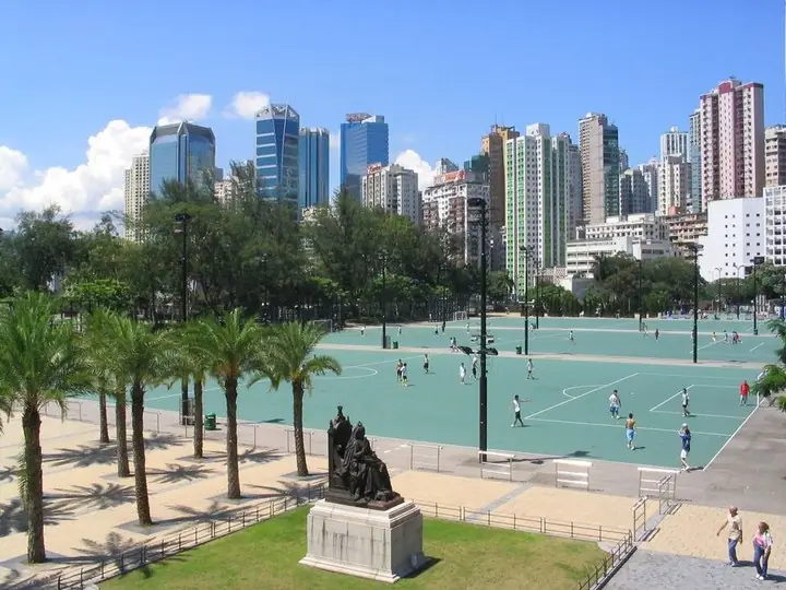 Sports courts and paths in Victoria Park, Hong Kong · 香港维多利亚公园球场与步道 Photograph date recorded by the source: June 2006.
Victoria Park维多利亚公园
Victoria Park is a large public recreation space between Causeway Bay and Tin Hau. Its central lawn, model-boat pool and planted walking areas sit alongside sports courts and pitches. The result is a park shaped as much by…
Read the place guide →Plan your visit
Getting there
Wan Chai District is about 4 km in a straight line from central Hong Kong. Search for 灣仔 in a map app to find stations and your accommodation.
Where to stay →Build your route
Blue House and Golden Bauhinia Square are about 1 km apart in a straight line. The linked place guides have entrance and visit details.
Continue with Hong Kong →More in Hong Kong
Sources & geographic information
Administrative names and parent areas: Official geographic directory · Reference date 2026-09-06.
Some facts checked against Wan Chai District — Wikipedia contributors, CC BY-SA 4.0.
Photo: Blue House · 方畢可 · CC0. Proportionally resized and converted to WebP without cropping, retouching or changing the photographed subject.

Photo: Golden Bauhinia Square · LN9267 · LN9267 — Golden Bauhinia Square 05-05-2021.jpg — CC BY-SA 4.0 · CC BY-SA 4.0. The exact downloaded source bytes are separately retained and hashed. Prepared JPEG is proportionally reduced to a maximum 720-pixel long edge; full frame retained, no subject alteration. Final website rendition: full frame retained, proportionally resized to at most 720 pixels and converted to WebP. No additional retouching or subject alteration. Card displays may crop the view.

Photo: Happy Valley Racecourse · Minghong · Minghong — Happy_Valley_Racecourse_1.jpg — CC BY-SA 4.0 · CC BY-SA 4.0. The exact downloaded source bytes are separately retained and hashed. Prepared JPEG is proportionally reduced to a maximum 720-pixel long edge; full frame retained, no subject alteration. Final website rendition: full frame retained, proportionally resized to at most 720 pixels and converted to WebP. No additional retouching or subject alteration. Card displays may crop the view.

Photo: Victoria Park · Baycrest · Baycrest — Victoria_Park_0606.JPG — CC BY-SA 2.5 · CC BY-SA 2.5. The exact downloaded source bytes are separately retained and hashed. Prepared JPEG is proportionally reduced to a maximum 720-pixel long edge; full frame retained, no subject alteration. Final website rendition: full frame retained, proportionally resized to at most 720 pixels and converted to WebP. No additional retouching or subject alteration. Card displays may crop the view.

Map data © OpenStreetMap contributors. Pins mark approximate centres, not entrances or boundaries.