


Get to know Liangzihu District
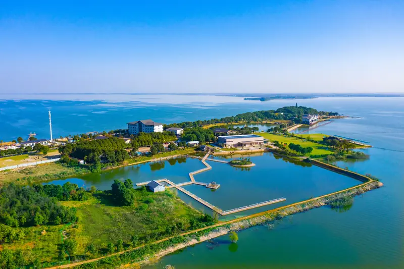
Photo adjustments
EXIF orientation normalized; resized without changing aspect ratio; converted to WebP. No subject edits.
- Administrative area
- District · 市辖区
- Part of
- Ezhou
- Chinese name
- 梁子湖区
- Local areas
- District guide
Area & population
- Area in the source
- 482.50 km²
- Population · 2020
- 126,822
Source: cited geographic source, as of the dates shown.
Setting and landscape
The district lies where the Han River plain gives way to the hills of the south-east. Outliers of the Mufu Mountains (幕阜山) rise to 200-300 metres in the east and south-east, with Zhaoshan Peak (沼山峰) the highest point at 418 metres, while a plain of low ridges runs through the middle. The district government describes Liangzi Lake as Hubei's largest freshwater lake and "the mother lake of Wuchang fish" (武昌鱼), and notes that it has islands in the lake and lakes on the islands. Its sub-lakes within the district include Caijiaxie (蔡家澥) and Tuzhen Lake (涂镇湖). The Changgang channel (长港) links Liangzi Lake with the Sanshan, Baoan and Ya'er lakes and drains the system to the Yangtze.
History
Stone tools, tripod vessels and pottery shards from sites such as Jinpennao (金盆垴) in Taihe (太和镇) show people living here from the Neolithic. The lake area belonged to E County under the Qin and Han and to Wuchang County from the Sui to the Qing. When Ezhou city was formed in 1983, Liangzihu became a branch district of the city, and in October 1987 the State Council made it a full county-level district.
What to see
Liangzi Island (梁子岛), in the middle of the lake, is surrounded by water and shaped like a water caltrop. The district government records that it made pottery in the Tang and Song, served the Wu state as a place to review and drill troops in the Three Kingdoms period, and was called "Little Hankou" (小汉口) in the Ming and Qing for its waterborne trade. The Liangzi Island eco-tourism area is a provincial tourist resort. Provincial heritage sites include the Neolithic Jinpennao site and the Wayaohai kiln site (瓦窑海遗址), a late Qing kiln whose excavated pottery has been exhibited in Britain. Qingfeng Temple (青峰寺), Zhaoshan Temple (沼山寺) and Wuchang Temple (武昌观) are the religious sites the district government lists, and wartime sites include the former offices of the Hunan–Hubei–Jiangxi border region. Longtang village (龙塘村) in Donggou (东沟镇) is the home of the calligrapher Zhang Yuzhao (张裕钊), founder of the Zhang style.
Getting oriented
The district seat at Taihe is 75 km from Wuhan and 59 km from the Ezhou urban area. The Ezhou–Xianning Expressway, National Highway 316 and an 84-km lakeside greenway run through the district.
Highlights
- Liangzi Island 梁子岛: Island in the middle of Liangzi Lake, once called Little Hankou; core of a provincial tourist resort.
- Jinpennao Site 金盆垴遗址: Neolithic site listed at provincial level.
- Wayaohai Kiln Site 瓦窑海遗址: Late Qing kiln site listed at provincial level; its pottery has been shown in Britain.
- Zhaoshan Peak 沼山峰: Highest point of the district at 418 metres.
Sources for this guide
梁子湖区概况 · Liangzihu District People's Government, Ezhou
地理位置 · Liangzihu District People's Government, Ezhou
历史沿革 · Liangzihu District People's Government, Ezhou
自然环境 · Liangzihu District People's Government, Ezhou
文物资源 · Liangzihu District People's Government, Ezhou
Original English written from the listed sources and checked sentence by sentence against quoted extracts by a separate reviewer. Updated 2026-09-24.
Explore Liangzihu District
Core places to explore, with English and Chinese names.
Liangzihu District 梁子湖区
Plan your visit
Getting there
Liangzihu District is about 40 km in a straight line from central Ezhou. Search for 梁子湖区 in a map app to find stations and your accommodation.
Where to stay →More in Ezhou
Sources & geographic information
Administrative names and parent areas: Official geographic directory · Reference date 2026-09-06.
Map data © OpenStreetMap contributors. Pins mark approximate centres, not entrances or boundaries.