


Get to know Macheng
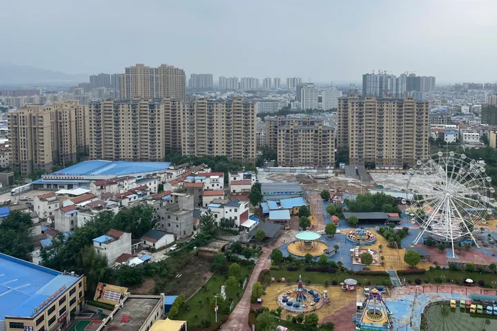
Photo adjustments
Full frame retained; proportionally resized and converted to WebP. No retouching or changes to the photographed subject. Card displays may crop the view.
- Administrative area
- County-level city · 县级市
- Part of
- Huanggang
- Chinese name
- 麻城市
- Local areas
- County-level city guide
Area & population
- Area in the source
- 3,600.00 km²
- Population · 2020 census
- 893,654
Source: cited geographic source, as of the dates shown.
Setting and landscape
Ridge lines separate Macheng from Xin County (新县) and Shangcheng County (商城县) in Henan, and a boundary ridge divides it from Jinzhai (金寨县) in Anhui; Luotian lies to the east and Hong'an to the west. The Ju River (举水), the city's largest river and a direct tributary of the Yangtze, rises at Futianhe town (福田河镇) and runs 122.5 kilometres through the city. The Ba River (巴水) rises on Lifeng Mountain (李峰山) in Muzidian town (木子店镇). Fuqiaohe Reservoir (浮桥河水库) is its largest reservoir.
History
The city government places the Battle of Boju (柏举之战) between Wu and Chu in Macheng. The county was set up and given its present name in 598, under the Sui, and became a city in 1986. From the late Yuan to the mid-Qing it was a gathering and departure point for settlers moving to Sichuan, and a rhyme told in Sichuan and Chongqing names "Xiaogan township in Macheng" (麻城孝感乡) as the ancestral home.
Macheng was an important part of the E-Yu-Wan soviet area; the city government counts 143,000 local dead in the revolution and 49 generals of the People's Republic from the city, 26 of them from Chengmagang town (乘马岗镇).
What to see
Guifeng Mountain combines a granite formation likened to a giant turtle with about 100,000 mu of wild ancient azaleas, rated by the Shanghai Great World Guinness headquarters as the largest ancient azalea community in China. It became a national 5A scenic area on 27 December 2024, the first in eastern Hubei. The city government also points to Baizi Pagoda (柏子塔), the Lei Clan Ancestral Hall (雷氏祠), Jiulong Mountain (九龙山) and Shizi Peak (狮子峰) in the Dabie Mountains world geopark, Fenghuang Lake (凤凰湖) national wetland park, the historic town of Qiting (歧亭镇), Xinghua village (杏花村) and the Xiaoganxiang Cultural Park (孝感乡文化公园).
Food and local products
The Macheng hanging pot (麻城吊锅) is cooked in the eastern hills, where homes have a fire pit with a hook hung from the roof beam. In winter a pot hangs over the fire and cured meat, fish noodles, meat cake and fried tofu simmer together in layers: one layer for family meals, three for guests from afar, five for a new baby. Fubai chrysanthemum (福白菊) and black goats are among the city's farm products.
Getting oriented
Macheng is 113 kilometres northeast of Wuhan and 110 kilometres from Huangzhou. The Beijing–Kowloon, Shanghai–Wuhan–Chengdu and Hankou–Macheng railways and five expressways, including the Daqing–Guangzhou and Shanghai–Chengdu routes, pass through the city.
Highlights
- Guifeng Mountain 龟峰山: Granite 'turtle' peak with about 100,000 mu of ancient azaleas; 5A scenic area since December 2024.
- Xiaoganxiang Cultural Park 孝感乡文化公园: Park on the Ming–Qing migration from Macheng to Sichuan.
- Baizi Pagoda 柏子塔: Pagoda the city government lists among its two 'treasures'.
- Macheng hanging pot 麻城吊锅: Layered pot of cured meat, fish noodles, meat cake and tofu simmered over a hearth.
Sources for this guide
麻城概况 · Macheng Municipal People's Government
从“一季红”到“四季火”!创建5A,麻城龟峰山底气何来 · Macheng Municipal People's Government (from Macheng Media Centre)
麻城吊锅 · Macheng Municipal People's Government
麻城市 - 维基百科 · Wikipedia (Chinese) · CC BY-SA 4.0
Original English written from the listed sources and checked sentence by sentence against quoted extracts by a separate reviewer. Updated 2026-09-24.
Explore Macheng
Core places to explore, with English and Chinese names.
Places to explore around Macheng
 AI illustration · AI
 Plan your visit
Getting there
Macheng is about 80 km in a straight line from central Huanggang. Search for 麻城市 in a map app to find stations and your accommodation.
Where to stay →Build your route
Start with Guifeng Mountain (Hubei). The linked place guides have entrance and visit details.
Continue with Huanggang →More in Huanggang
Sources & geographic information
Administrative names and parent areas: Official geographic directory · Reference date 2026-09-06.
Some facts checked against 麻城市 — Wikipedia contributors, CC BY-SA 4.0.
Map data © OpenStreetMap contributors. Pins mark approximate centres, not entrances or boundaries.