


Get to know Tuanfeng County
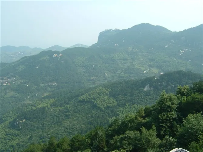
Photo adjustments
Full frame retained; proportionally resized and converted to WebP. No retouching or changes to the photographed subject. Card displays may crop the view.
- Administrative area
- County · 县
- Part of
- Huanggang
- Chinese name
- 团风县
- Local areas
- County guide
Area & population
- Area in the source
- 838.40 km²
- Population · 2020
- 266,218
Source: cited geographic source, as of the dates shown.
Setting and landscape
Three river systems cross the county: the Yangtze, the Ba River (巴河) and the Ju River (举水). The Yangtze runs through the county for more than ten kilometres, and a port area at Tuanfeng is part of the overall plan for the new Port of Wuhan. The county lies 20 kilometres from urban Huanggang and 16 kilometres from Huangzhou (黄州) railway station, and the Beijing–Kowloon railway runs through it. Its old nicknames are 'Gateway to Eastern Hubei' and 'Little Hankou'.
History
Tuanfeng's old name is Wulin (乌林), from the crows that rested in its reed beds before the Tang. The settlement dates from the Tang and had become a market by the Song. Cao Cao (曹操) once garrisoned troops at Wulin, and Zhu Yuanzhang (朱元璋) defeated Chen Youliang (陈友谅) here. In the Ming and Qing it was one of the trading ports along the Yangtze. The county government counts the geologist Li Siguang (李四光), the philosopher Xiong Shili (熊十力) and Wang Yanan (王亚南), translator of Capital into Chinese, among its people. The Sixth Army of the Chinese Workers' and Peasants' Red Army was formed here.
What to see
Daqi Mountain (大崎山) is a provincial forest park called the 'Mount Tai of eastern Hubei', and the Niuche River (牛车河) leisure area is known as the 'Thousand-Island Lake of eastern Hubei'. The county government also lists the Yangcha Lake (杨汊湖) resort, the Huilong Mountain (回龙山) scenic area, the Longwang Mountain (龙王山) summer retreat, Luohuo Island (罗霍洲) in the Yangtze and the Dupi Martyrs' Cemetery (杜皮烈士陵园).
Tuanfeng string-and-gong music (丝弦锣鼓) combines more than 20 percussion, wind, plucked and bowed instruments. The tradition of Xiongjiawan (熊家塆), a village in Jiamiao township (贾庙乡) below Daqi Mountain, dates from the Yongzheng reign of the Qing; it was played at sacrifices, festivals, weddings and funerals, and became provincial intangible heritage in 2013. The ensemble keeps time by the ma luo (马锣), a gong named for its horse-hoof shape, which players sometimes toss upwards and catch mid-performance.
Food and local products
Tuanfeng water chestnuts (团风荸荠) are a national geographical-indication product, protected in Linshanhe (淋山河镇), Fanggaoping (方高坪镇) and Machaomiao (马曹庙镇) towns. Records of the crop go back to the 1759 Huanggang county gazetteer. The corms are thin-skinned, reddish brown, white-fleshed, sweet and crisp, eaten raw like fruit or cooked, for example candied or braised with pork. Fish noodles (鱼面), locally called 'pounded fish', were already made by lake fishermen before 1949, with Linshanhe, Xujialou (徐家楼) and Tuanfeng known for them.
Highlights
- Daqi Mountain Forest Park 大崎山: Provincial forest park the county government calls the 'Mount Tai of eastern Hubei'.
- Niuche River leisure area 牛车河: Known as the 'Thousand-Island Lake of eastern Hubei'.
- Tuanfeng water chestnuts 团风荸荠: National geographical-indication product since 2009, recorded in the Huanggang county gazetteer of 1759.
- Tuanfeng string-and-gong ensemble 团风丝弦锣鼓: Folk ensemble tradition from the Yongzheng reign, provincial intangible heritage since 2013.
Sources for this guide
团风概况_团风县人民政府 · Tuanfeng County People's Government
团风荸荠_团风县人民政府 · Tuanfeng County People's Government
溢流河鱼面_团风县人民政府 · Tuanfeng County People's Government
团风丝弦锣鼓:深山里的“交响乐团”_团风县人民政府 · Tuanfeng County People's Government
Original English written from the listed sources and checked sentence by sentence against quoted extracts by a separate reviewer. Updated 2026-09-24.
Explore Tuanfeng County
Core places to explore, with English and Chinese names.
Tuanfeng County 团风县
Plan your visit
Getting there
Tuanfeng County is about 20 km in a straight line from central Huanggang. Search for 团风县 in a map app to find stations and your accommodation.
Where to stay →More in Huanggang
Sources & geographic information
Administrative names and parent areas: Official geographic directory · Reference date 2026-09-06.
Map data © OpenStreetMap contributors. Pins mark approximate centres, not entrances or boundaries.